 SKY WATCH FRIDAY time! Thanks to Dot and Tom, never forgotten founders of this great event. Come on, come fly with us!
Thanks to hosts: Klaus Sandy Sylvia Wren Louise Fishing Guy
For Skywatch Friday, I want to post a few inspirational skies and one interesting sky. The first was just a powerful homecoming sky! What a beautiful way for the Lord to welcome me “home” after a dreary day. I snapped this shot driving into my neighborhood!
The next is just an amazing sky on fire shot, one summer evening. I love it when that happens!
The last one, I took Monday. We had some crazy weather with severe potential throughout the day, and I looked around to notice this eerie yellow/green sky after a hard rain. Of course, me and my optimism were seeking out some slight sign of rotation to no avail, but the sky was notable to the point where people talked about the eerie yellow/green sky all day, even kids.
What a tropical mess! Tropical Storm Nicole was such for a matter of hours, but between her and the non-tropical low over the east coast, rain has been and will be unrelenting. We had a line of storms trained over us for the ENTIRE day yesterday! It was some obscure little lost line of storms that literally started before work and didn’t stop until after I left. The low pressure system over the east coast was sucking all the moisture out of Nicole and just inundating everybody. We survived it. It was actually nice to have such rain after such a long spell without. My thoughts turn to the central coast though. They just had that frontal system pass through which offered up record rainfall 10+” in a day. Now, they are experiencing a steady stream of drenching rain… they are facing 20+” in 3-4 days time. That is deadly flooding potential.  Incidentally, flooding is the leading cause of weather-related deaths in the U.S., with approximately 93 deaths per year (the 30 year average). It is so important that if you see water over a road, you do NOT attempt to drive in it. Turn Around, Don’t Drown™. I can assure you that some of the infrastructure of those areas cannot support that much rain, in that short of a time. This is a deadly recipe…
  I know it’s totally off the subject, but I wanted to share with you that my wonderful groom surprised me with a beautiful (weather-related… SUNflowers) bouquet of flowers yesterday, in celebration of our 3-year Date-iversary. I am so blessed to have him to share my life with!! Definitely a heart smile...
Have a glorious day!
~Dewdrop
Thursday, September 30, 2010
Have a bright, SUNflowery day!
Thursday, September 23, 2010
Could we have the beginnings of Matthew???
SKY WATCH FRIDAY time! Thanks to Dot and Tom, never forgotten founders of this great event. Come on, come fly with us!
Thanks to hosts: Klaus Sandy Sylvia Wren Louise Fishing Guy
 Well, here we are facing the highly likely development of Matthew in the southeastern Caribbean. This is one that has piqued the interest of many, as many models have brought this disturbance into the Gulf of Mexico. Tropical Depression Lisa is barely churning in the far eastern Atlantic.
  The remnants of Julia are trying to act organized, but it’s the low pressure in the Caribbean that has everyone in a tizzy. Tropical Depression 15 will likely take center stage as a US media hog by the end of the day.
Here is a sky shot for your soul… A sunset not too long ago...
Have a great day!
~Dewdrop
Thursday, September 16, 2010
A little pick-me-up...
SKY WATCH FRIDAY time! Thanks to Dot and Tom, never forgotten founders of this great event. Come on, come fly with us!
Thanks to hosts: Klaus Sandy Sylvia Wren Louise Fishing Guy
Sorry for the delay. I've been down and out with my recovery, but I want to post a cool sky from the other morning. It was my first morning on my own taking care of Mini-Dew in the morning after surgery, and God decided to offer me a little pick-me-up... not altered except resizing. This is how it actually looked (except better)...
Also, when my wonderful from and I worked on our garden, we put up a couple of hummingbird feeders, and much too my delight, they have already found them. We have 3 visiting that I know of. This is one of them that I caught in action. I hope to get some great shots along the way as they get more comfortable with me.

I am thrilled to have these whimsical guests to entertain me during recovery!
Have a glorious day!
~Dewdrop
P.S. The tropics are active, but nothing should directly impact the U.S. in the near future. Interests in Bermuda should have both eyes on Igor though!
Friday, September 10, 2010
Here I am...
OK, so I've been out of the loop for the last week. I had a tonsillectomy on Tuesday, which really sucked the life out of me. I am just now starting to feel somewhat like myself, so I figured I would pop in and say hello. During my absence, we had two more named storms pop up. Tropical Storm Hermine was actually a remnant of Pacific storm 11E, but it crossed over into the Gulf before being named, so it earned the name Hermine and inundated Texas with way too much rain, causing devastatingly deadly flooding. It also spawned some tornadoes. Now, we have Tropical Depression Igor way out in the Atlantic, expected to regain strength. ... then, there is the area in the Caribbean, which has a slight chance of development. When that season kicked in, it kicked in with a bang.
I'm going back to bed.
~Dewdrop
Thursday, September 02, 2010
Halo...
SKY WATCH FRIDAY time! Thanks to Dot and Tom, never forgotten founders of this great event. Come on, come fly with us!
Thanks to hosts: Klaus Sandy Sylvia Wren Louise Fishing Guy I just wanted to take a break from all the hurricane chatter, so here you are... A brilliant solar halo!!!
Have a great day!
~Dewdrop
Africa just keeps waving at us!!
 Hurricane Earl, now a very powerful category 4 storm, refused the dry air that infused earlier this morning, and came through it just a strong. I am concerned for the impact that Hurricane Earl will have on the coast. The good news is that right now, he is a fast moving storm, so the impact won’t last for a long time, but the size, the power and the proximity to land will impact interests along the east coast, whether he comes ashore or not. Already States of Emergency have been declared from North Carolina, up into Maryland. They are still not ruling out a landfall. We’ve seen storms do very unpredictable things as they approach land. A forecast is just an expectation. It is imperative that people prepare for the unexpected. Only 11 mph distinguish between what Earl is now and a catastrophic category 5 hurricane. Sadly, I think some level of devastation might be unavoidable. I pray that people are heeding the evacuation orders, that they have rushed preparations to completion and that impact is less than expected. Go east, Earl!
Fortunately, it looks like Tropical Storm Fiona is too caught up in the outflow of Earl to make much of an impact. The expectation there is that Fiona will quickly move eastward, possibly moving over Bermuda, but she should not pose a threat to the US coastline.  The one many have a hard eye on is Tropical Storm Gaston. He is currently just hanging out in the Atlantic, but models are doing some scary things with that system, potentially even moving him into the warm waters of the Gulf of Mexico. That is far from ideal. He is already forecast to become a hurricane before reaching the Lesser Antilles. Everyone has an eye on Gaston… that is while keeping the other on Earl.
 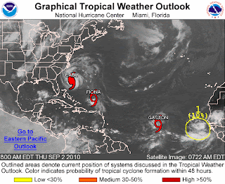 I’m not even going to get into the next wave that has rolled off the coast of Africa. Could we have Hermine???
Have a beautiful day.
~Dewdrop
Wednesday, September 01, 2010
Busy season...
As Hurricane Earl breezes by the Bahamas, leaving everyone along the east coast wonder what type of impact he will have on their Labor Day plans, Tropical Storm Fiona starts to intensify.  Having placed some distance between herself and the powerful category 3, Fiona has had an opportunity to strengthen slightly. The forecast does not have her reaching hurricane strength, but they do have YET ANOTHER problem area highlighted for another wave that has rolled off the African coast, where they are giving that one an 80% likelihood of development into a tropical system. We could see the beginnings of Gaston.
 Back to Earl though, Hurricane Earl, a powerful category 3 storm, just downgraded to a category 3 storm after losing a bit of his bite through an eye-wall replacement cycle. Unfortunately, it appears that Hurricane Earl has regrouped and the eye-wall looks as strong as ever, which would lend to some likely intensification, but that is a typical ongoing process for major hurricanes, fluctuations in strength.
  All eyes are on Earl as he races across the Atlantic, the cone of possibilities slowly creeping westward with each model run, which places a more imminent threat on interests along the coast. Anyway you look at it, the east coast (and much of it) will be impacted by Hurricane Earl, just how badly is yet to be seen.
Have a great day!
~Dewdrop


