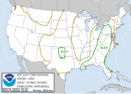
Well, we racked up a total of 1.66 inches of rain yesterday and this morning. Not bad. We certainly needed it. Things never got severe where I am, except at the AFB where 50 kt winds were reported. Here is a report of the severe weather in my area from yesterday. Lots of wind and hail. I have heard a report of a funnel cloud in Adel that wanted to drop, but that could just be people talking. You know how that goes. There was some wind damage in that county, but no funnel clouds mentioned... All-in-all, a nice event... not severe for me, but good rain, which we needed, so I'm happy. I was able to provide some minimal radar support for Carolina Mike (once I found NC, lol) to assist in his ride home. His hopes of shooting CG were squelched... poor guy. Today, there exists a slight risk for severe weather all along the eastern CONUS. Just now beginning to observe some CU towers trying to bust through today's weak cap. Conditions are favorable for some isolated severe thunderstorms over our area. We'll see what happens. I have GR up, I will continue to monitor the area for anything significant.
 This MD was just issued which explains that shear is sufficient to encourage the development of multicells and a few supercells. It looks good for something to occur, but unfortunately, I am on the outer edge of the potential area for a likely watch.
Other than that... I have nothing else.
Toodles,
~Dewdrop
Wednesday, June 13, 2007
All this slight risk... will it happen?
Subscribe to:
Post Comments (Atom)


No comments:
Post a Comment
Dew comment, please...