Currently, severe weather is making its presence known across portions of the south, with some hail (up to 1 1/4") and wind (trees down) reports already posted on the Storm Prediction Center website.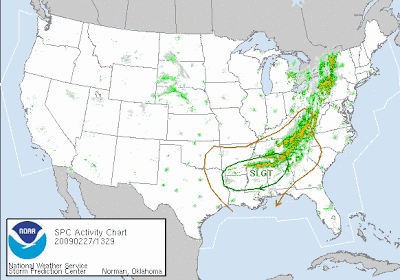 Several cells up in Alabama Mike's neck of the woods are severe warned, and I caught a glimpse of some tornado warned cells feeding in from Mississippi. This is a continuation of yesterday's event, where the plains states reported 60 instances of severe hail (up to 1 3/4") and wind (gusts to 70mph). Here's the thing though, with the moisture and the extremely cold temps, they are talking about snow and some possible accumulation as far south as Atlanta on Sunday. Of course, when you go from 70° weather to accumulations of snow, you've got to have something powerful in between.
  So, severe weather... or as Meso Mike has stated:
 "The ingredients for “severe soup” looks like it made its way into the pot ;-)"
The wording int he outlook isn't powerful, based on some possible inhibiting factors...DURING THE DAY...WARM SECTOR DESTABILIZATION AND A STEADY INFLUX OF BOUNDARY LAYER MOISTURE SHOULD SUPPORT A CONTINUED SEVERE RISK AND A DIURNAL REINVIGORATION OF TSTMS ACROSS SOUTHERN/EASTERN AL INTO GA/FL PANHANDLE. ALTHOUGH STRONG WIND FIELDS/AMPLE SRH WILL CONDITIONALLY SUPPORT A TORNADO RISK. AHEAD OF THE ADVANCING SURFACE LOW/COLD FRONT...STRONG DEEP LAYER WIND FIELDS/AMPLE DIURNAL VEERING WILL SUPPORT POTENTIAL FOR BOTH QUASI-DISCRETE SUPERCELLS /MAINLY DIURNALLY/ AND BOWS WITH MULTI-FACETED SEVERE RISKS OF DAMAGING WINDS/A FEW TORNADOES AND PERHAPS SOME SEVERE HAIL. IF NOT BEFORE...A SQUALL LINE/LINEAR MODE SHOULD BE DOMINANT BY SATURDAY NIGHT ACROSS NORTHERN FL/SOUTHERN GA AS MID LEVEL WINDS BACK/BECOME MORE UNIDIRECTIONAL AHEAD OF THE APPROACHING UPPER LOW.
I'm sure you know that I am not a big fan of the night time squalls... looks like my forecast is leaning that way. Quoting an email from meteorologist, Jeff Rucker in Augusta... An unseasonably strong mid-level trough will drop as far south as northern Florida early Sunday. This brings a severe threat Saturday afternoon and a possibility of flurries or light snow late Sunday night.
So, today, tonight, tomorrow, and tomorrow night, Georgia could see some more action... and then, snow.
Here is our timeline:
Showers move in from west late this afternoon and evening
Heavy rain overnight and in the morning. Rain totals 1 to 2 inches. Heavier rain over north GA and upstate SC.
Chance for severe especially south and east of Augusta Saturday noon to 8pm.
Colder with showers/drizzle Saturday night through most of Sunday
Flurries or light snow showers possible late Sunday night and early Monday.
As with any unusual weather system, the exact track of low pressure will determine where we get the heaviest rain and the highest threat of severe weather.
Weird, weird weather.
11:10EST tornado report... CHELSEA SHELBY COUNTY AL
1:45PMEST:
TREES AND POWER LINES DOWN IN CHELSEA NEAR POST OFFICE ON US HWY 280. CONFIRMED TORNADO.CONCERNING...SEVERE THUNDERSTORM WATCH 37...
~Dewdrop
THE SEVERE WEATHER THREAT FOR SEVERE THUNDERSTORM WATCH 37 CONTINUES.
TRENDS ARE BEING MONITORED FOR THE POSSIBILITY OF INCREASING TORNADIC POTENTIAL...A NEW TORNADO WATCH WILL LIKELY BE ISSUED SOON.
Friday, February 27, 2009
Severe weather outbreak today and tomorrow, then snow
Subscribe to:
Post Comments (Atom)


So you are a storm chaser! That must cost a lot of energy and perseverance.
ReplyDeleteIndeed! :D
ReplyDelete