Well, rain poured down in the Atlanta area yesterday causing the flash flooding that everyone feared, falling on already saturated ground, causing the rivers and creeks to crest above flood stage. Unfortunately, that is just an appetizer. 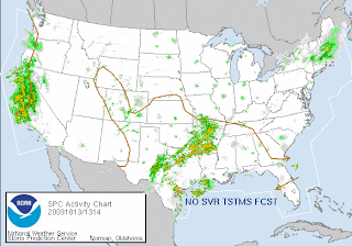 Another dose of flooding rain is rolling in tomorrow, which will put much of north Georgia under water. Now, that area of storms over on the west coast... guess what that is... It's the system formerly known as Super Typhoon Melor. That's right, the remnants of Melor have tracked all the way across the Pacific Ocean and have decided to pummel the west coast of the US with flooding rain. That area is preparing for mudslides. As if they didn't have their share of natural disaster with all the wild fires they endured over the summer.
We've had dreary skies and rain/drizzle in my neck of the woods, which seems to be taking its toll on people, that and the sticky humidity... I think we are ready for some colorful fall-like weather!
Have a superb day!!
~Dewdrop
Tuesday, October 13, 2009
Flooding and the leftovers
Friday, September 25, 2009
Epic flood called 500 Year Flood
 The flooding in Georgia that took place this week is now being referred to as an epic 500-Year-Flood.
 At least 10 deaths in Georgia and Alabama were blamed on the torrential downpours in the Southeast. The storms finally relented and relief was in sight with just a slight chance of rain Wednesday, but the onslaught left many parts of the region in stagnant water.
According to the USGS website...
The latest victim, Richard Butler, 29, drowned after his car was apparently washed off a road near a creek Tuesday night in suburban Douglas County, west of Atlanta, county spokesman Wes Tallon said.
~sourceThe flooding around Atlanta this week is one for the record books. According to the U.S. Geological Survey (USGS), the rivers and streams had magnitudes so great that the odds of it happening were less than 0.2 percent in any given year. In other words, there was less than a 1 in 500 chance that parts of Cobb and Douglas counties were going to be hit with such an event.
Allow me now to just share with you some of the shocking photos that have come out of the flood-stricken areas... it's hard to imagine going through something like this... such a long road lies ahead for some of these people!
“The USGS can reliably say just how bad these floods were. They were epic!” said Brian McCallum, Assistant Director for the USGS Water Science Center in Georgia. “We have all witnessed the devastation caused by these floods, but now we can quantify it.” The data are gathered from the USGS real-time streamgaging network.
On Sept. 22, USGS crews measured the greatest flow ever recorded (28,000 cubic feet per second) on Sweetwater Creek near Austell, Ga.
Elsewhere in the Atlanta area:
The Yellow River streamgages in Gwinnett, DeKalb and Rockdale counties measured flows between the 1 percent chance (100-year) and 0.5 percent chance (200-year) flood magnitude.
Flows caused by the rain at Peachtree Creek in Atlanta were only near the 10 percent chance (10-year) flood magnitude, but the backwater effects from the Chattahoochee River pushed water levels over the 0.2 percent chance (500-year) flood at the gage location.
On the Chattahoochee, USGS measured a 1 percent chance exceedence (100-year) flood at Vinings and Roswell.
~source From left: Garrett Jacobs, Dakota Nelson, and Levi Wright move a barricade to higher ground after flood waters from the Yellow River continued to rise Monday, Sept. 21, 2009 in Lilburn. Ga. The community canceled their beach bash, which was scheduled for Monday night. (AP Photo/Atlanta Journal-Constitution, Curtis Compton)
  From left, Allen Rice, Zach Shirley, Jacob Shirley, and Danny Shirley remove two mattresses from their home in East Ridge, Tenn., Tuesday, Sept. 22, 2009. Heavy rainfall caused water from area creeks to flood areas throughout Chattanooga and northern Georgia areas. (AP Photo/Chattanooga Times Free Press, Patrick Smith)
The roof of an auto shop is barely visible above swollen Sweetwater Creek after heavy rains of recent days caused the creek to flood, Tuesday, Sept. 22, 2009, in Austell, Ga. (AP Photo/John Amis)  An unidentified man looks back at tractor trailer cars washed against a bridge going over Sweetwater Creek left there by flood waters from recent rains, Wednesday, Sept. 23, 2009, in Austell, Ga.(AP Photo/John Amis)
  A submerged truck is shown in flood waters in Mableton, Ga., Tuesday, Sept. 22, 2009. Heavy rains caused flooding in and around the Atlanta area. (AP Photo/John Bazemore)
  Grounds crew including Michael Watts, Jr., second from left, work at cleaning up mud and debris at the foot of the Ninja roller coaster, left by flood waters that inundated Six Flags over Georgia amusement park, Thursday, Sept. 24, 2009, in Atlanta. (AP Photo/John Amis)
  Mud encased bicycles lay strewn in front of a house in Lilburn after flood waters from the Yellow River receded from it, Wednesday, Sept. 23, 2009, in Austell, Ga. A newly built deck on the back of the house was nowhere to be found. (AP Photo/John Amis)
Have a blessed weekend!
~Dewdrop
Wednesday, April 15, 2009
Flood recovery in Valdosta
Well, several things to talk about today... First, the National Weather Service in Tallahassee has offered their assessment of the storm on April 13 that has supposedly dropped tornadoes within their county warn area (CWA). They have determined all the damage to be caused by straight line winds.One of my co-workers mentioned that he was told that his whole town back home was destroyed... Cobb, Georgia... Don't know what that's all about.
I went into my dear in-laws' tragic flood damaged Valdosta Meadowbrook neighborhood yesterday evening to drop off something, pick up some things and check in on them. They were walking out the door to check out some of the area. My sweet mother-in-law walked with me over to the home across the street from hers, which was a rental. The neighbors are concerned about the health risk, as no one has entered the structure to remove the damaged and water filled furniture... no one has torn down sheet rock or ripped up carpeted floors... the smell was horrendous, and the renters have just abandoned the structure. I shared one of Haley's pictures of the house yesterday. You know, the one where the water line was mere inches from the roof line. Standing beside the house was humbling... standing on their top stair, the water line was over my head. It's a shocking thought that those homes had water rise that high around their homes. Additionally and sadly, I heard that with Monday's rain and some further uncertainties, the local officials warned people in that neighborhood, now working hard on recovery efforts, that water levels were expected to rise once again...
 National Weather Service
Southeast River Forecast Center
Hydrologic Vulnerability Assessment – Suwannee River Update
11:45 PM Monday April 13, 2009
Major Flooding - Extensive inundation of structures and roads. Significant evacuations of people and/or transfer of property to higher elevations. Tallahassee's Report of Severe Weather and Flooding of Late March and Early April 2009. I can't imagine dealing with losing everything in my home... losing my home... and being told while trying to pick through the wreckage that it might happen again. I can't imagine how overwhelmed these people must feel. The piles of debris lining the roads was unbelievable, and according to my mother-in-law, it was worse over the weekend with piles of furniture, large appliances, carpeting, and basically... everything filling the sides of the road, leading a lonely strip of road available for local traffic and relief vehicles which were present in abundance while I was there. It looked like the local power company was establishing emergency power to the homes while I was there... going house to house... that tree in the neighbor's yard, the one that was leaning heavily for years was removed by the Baptist Relief organization, who had a fleet of volunteers there working in the neighborhood. My sweet mother-in-law commented that it was shocking to look at the neighbor's house and see through to the other side, where only framing still stands. The smell in the Meadowbrook neighborhood was nauseating, but MUCH better than it was from what I understand. The mosquitoes are horrible! I was bit 8 times in the fewer than 10 minutes that I was out there. I hope the city is spraying the area since we have had West Nile virus present in our mosquito population. I have checked into getting the area sprayed (in case no one else has mentioned it up the line.) Local residents and relief workers have all received Tetanus shots free of charge. One home built on a slab was actually moved off its foundation. Unfortunately, the next issue to strike will be a significant mold crisis. Homes have had furniture, carpeting, flooring, ducts, walls, tiles ripped out, but mold will still grow at hazardous levels in those homes, becoming a health risk to people living in the neighborhood and especially to those planning to somehow move back into these structures. Even folks who didn't have water in their homes should look into having their crawl spaces checked for structural integrity from water and mold damage. I think I will just share the pics now... I know I promised phase 2 of the honeymoon in this post, but I just can't... I'll get to that tomorrow.
God bless all of those impacted. The LORD bless you, and keep you;
Update: I was just contacted by a City of Valdosta employee. Regarding the mosquito spraying, they have decided not to spray for mosquiotes at this time, because this is not the "season" for the bad stuff, such as West Nile. They have been dropping mosquito larvae treatment tablet into the flood waters and puddles though to prevent development. Apparently, they missed a few...
The LORD make His face shine on you,
And be gracious to you;
The LORD lift up His countenance on you,
And give you peace.
~Numbers 6:24-26
~Dewdrop
Tuesday, April 14, 2009
Update on Valdosta flooding and honeymoon: stage 1
 Yesterday, you know, on my very busy day back to work after using up my vacation time with the wonderful honeymoon... there were 4 tornado reports within 50-100 miles of my location, in Sylvester, Fitzgerald, Baxley and Donald, GA. I watched the cell in question as it raced across the southern part of the state, maintaining an excellent radar presence, all along the way. Arm-chair chasing can be fun, but one of these days... You can click on the graphic above for the full-report.
Explaining the Dewvoid: The Dewvoid is a made-up word, which was created by my storm chasing friends. As a storm chaser, it is necessary for there to be severe weather, which to chase. Unfortunately, there never seems to be any chase-able weather where I am, even when expected, or if there is severe (chase-able) weather, I am not able or in a position to be able to chase it (as was the case yesterday). My nickname is Dewdrop. Where I am is usually devoid of weather... hence, DEWVOID.
I want to share with you some pictures taken by my friend Haley Hyatt, as she explored one of the hardest hit areas during the flood in Valdosta last week. She actually took these shots after the flood had crested (and started to recede), and you can see where water lines are established about 4-6 feet above where the water level sits in these shots.  There is a road under all that water.
 Businesses to the left and right of this shot were consumed by flood waters. The road remained closed for much of the period.
 Sludge left in the road after the water has receded some.
 Note the water line, a mere inches from the roof. This home has been destroyed.
 Thank you, Haley, for kindly offering permission for me to share these drammatic captures of a quite historic event.
  Historic indeed... I have heard that local officials are suggesting that this might exceed not just the 100 year, not the just the 500-year, but it might actually be a 1 in 700-year flood event. FEMA is currently working on re-drawing the flood plain, unless they have already finished. Amazing... devastating... a truly traumatic event for all those impacted. For local information about the Lowndes County, Georgia flooding, contact 229.671.2400. Unfortunately, water rise is expected once again, as a result of a drenching rain received here and especially to our north yesterday. Let's hope and pray that things stay manageable, which is the expectation at this time. We needed the rain, sadly though... not that much, that fast. Thanks to my friend, Melissa, for the rain data from CoCoRaHS!
Onto a happier subject though... It's time for the description of stage one of our honeymoon. We stayed at a charming Bed & Breakfast in Dahlonega with an amazing sunset view of the mountains. 
 The breakfasts, the view and the wonderful care offered by our kind hostess, made it an incredible stay. We LOVED it! We spent our full day hiking around the area, going to a highly recommended waterfall (imagine that) which was co-located with an Army Ranger training base.
  As we drove through a rumbling creek (which was safe to cross and was actually included in the directions as part of the road we were traveling on), we passed a fleet of soldiers gearing up for departure on one of two helicopters. I don't know if it was an exercise or an actual deployment, but it was cool to say the least. We hiked the mountain-side to an amazing falls... the falls at West Fork on Montgomery Creek (I've linked it to Jack Anthony's picture of the same falls). When the falls came visible through the trees,
 ... we knew that we had no choice but to climb down for a better view, despite the less-than-perfect-for-the-climb-shoes I was wearing.
 It was well worth it, and as always with us... a great adventure. Later, we climbed up Cooper Gap, wishing we had some of those hiker poles... we're only slightly out-of-shape... cough, cough, but came across this approximately 5' black racer, sunning himself on a downed tree along the way.
 The view was spectacular, but hazy, so the pictures didn't really come out very well.
 Basically, our Dahlonega segment was about relaxing by the fire and just enjoying the magnificent scenery.
I'll cover stage 2 tomorrow.
There have been 3 tornado reports on the western central peninsula of Florida today.
Have a fabulous day.
~Dewdrop
Sunday, April 05, 2009
Moderate to major flooding in Valdosta continues...
 On account of my wonderful gtb becoming my groom this weekend, I am out of the area, so I don't have current pictures of the flooding in the Valdosta area, but I have gotten a bunch of reports. Many of the roads are already closed, due to moderate to major flooding and concerns about the integrity of the bridges over rushing water. Gornto Road, Troupville Road, Skipper Bridge Road, Highway 84, Highway 133, Shiloh Road, Park Lane, Meadowbrook Lane, Franklin Bridge Road and many, many more are closed. I know a part of I75 was actually covered in water on the way up. Unfortunately, I just got the CodeRED message while on the side of a mountain that water rise is expected to continue and gain another foot or two in water raise... and with upcoming storms this afternoon and evening, they are expecting another inch or two of rain fall... Many, many homes are flooded. People are being told to evacuate to the emergency shelter at Mathis Auditorium before water levels rise to dangerous levels at your home. Do not drive on flooded roads!!!! If you stay in your home past flooding, you endanger rescue crews. People are being advised not to travel if possible. I have never seen it this bad or heard of it ever being this bad. A State of Emergency has been declared by the governor. If you have any information to share, please share it in comments or feel free to email the to me to post at dewdrop_in_sga@yahoo.com.
Link to Flood Warning
Road Closure Article
Overcome by Water article
I'll be posting wedding and waterfall shots soon. Meanwhile, the Dewvoid holds strong presenting tornadoes back home while I am away... and the "severe event" once expected here has fizzled to a baby squall line.TORNADO REPORTS
When Dewdrop's away...
4 E ALAPAHA BERRIEN GA
POSSIBLE BRIEF TORNADO TOUCHDOWN JUST WEST OF WILLACOOCHEE. (TAE)
WILLACOOCHEE ATKINSON GA
A STORM SPOTTER REPORTED A POSSIBLE TORNADO ON THE GROUND NEAR HIGHWAY 90 JUST SOUTH OF WILLACOOCHEE. NO FURTHER CONFIRMATION OR DAMAGE HAS BEEN REPORTED. (JAX)
1 N BLACKSHEAR PIERCE GA
A STORM SPOTTER REPORT OF A POSSIBLE TORNADO IN BLACKSHEAR...60 TO 70 MPH WINDS AND DIME SIZE HAIL. (JAX)
Link to slideshow of flooded areas on VDTimes site (includes descriptions of locations and days)
Link to aerial views of Valdosta area during flood posted in VD Times article.Latest on flooding/recovery info from Lowndes County Emergency Management:
~Dewdrop
From today at the Lowndes County SITREP meeting:
1. Valdosta has created a flood information hotline 671-2400. Personnel
can call to report damage, inquire about school and road closures.
2. Florida State Patrol is expected to close parts of I-10 near the Suwannee
River as the crest moves south. Personnel traveling west of I-75 on I-10
should call the flood information center before committing to any travel.
3. Roll off dumpsters have been placed in flooded areas for home owner use.
If there are no dumpster, personnel should move trash to the right of way
for disposal.
4. Gornto Road remains closed, but Cat Creek and Skipper Bridge are expected
to reopen today.
5. Media Comm is flooded out and many customers are without cable, internet
and phone service. Service should be out through the Phase I exercise.
6. Valdosta Emergency Managers have asked that personnel do not
"self-deploy" to aid in the cleanup efforts. All volunteers should call the
information hotline to sign up for coordinated recovery teams.
7. As flood waters recede more bridges and roads will reopen as they are
inspected. Please continue to observe the posted closing and DO NOT drive
around any barricades.
8. Free water testing is available from the city of Valdosta for personnel
with wells. Call the information center for further instructions. The city
water is safe as the aquifer is over 200' deep and the water is continually
being monitored


