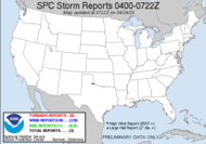
 Well, this is good to read, huh?.SPOTTER INFORMATION STATEMENT... SPOTTER ACTIVATION MAY BE NEEDED LATER TONIGHT AND FRIDAY. THE SEVERE WX POTENTIAL WITH THIS FRONT DOES NOT LOOK ALL THAT FAVORABLE AS MUCH OF THE SHORTWAVE ENERGY WILL EJECT OUT TOO QUICKLY TO THE NE. ALSO...ALTHOUGH THE THERMODYNAMICS WILL GENERALLY BE GOOD...THE TIMING OF THE CONVECTION DURING OVERNIGHT AND EARLY MORNING HOURS WILL LIMIT LOW LEVEL INSTABILITY. HOWEVER...THE SITUATION IS WORTH MONITORING AND SOME STRONG STORMS ARE STILL CERTAINLY POSSIBLE. It appears that the POPS on Saturday have gone down, still a slight chance Saturday night, but I'm hoping that will diminish for the parade's sake... On the plus side, POPS have gone up for Friday... and it's TSTMS they are forecasting 70%. Should be finished by 1:00 though, so because of work, I guess I will miss it all, in my storm chaser's nightmare of a cell without windows... At least, I might be able to hear the thunder... THE PROSPECTS FOR A NICE WEEKEND ARE IMPROVING FOR MUCH OF THE AREA.
All very good, except the lack of severity is a downer. So sad. Asi es la vida de la Dewdrop... Sorry, don't know the translation for Dewdrop... I would imagine that I am Dewdrop in any language though since I am one of a kind.
That's all I've got for now.
ttfn,
~Dewdrop
Thursday, November 30, 2006
Let it rain... let it wash right down on me.
Subscribe to:
Post Comments (Atom)


No comments:
Post a Comment
Dew comment, please...