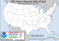
Prospects for Wednesday are getting more and more exciting as that time approaches. Models aren't in complete agreement yet, but the last time they agreed, we got nothing... I will stay cautiously optimistic... Check this out>> THE STRONGER STORMS LIKELY REMAINING CONFINED TO SRN GA AND FL PNHDL. THOUGH PRIMARY STORM MODE SHOULD BE LINEAR...EMBEDDED ROTATING STORMS WILL BE POSSIBLE GIVEN THE STRONG VERTICAL SHEAR. DAMAGING WINDS WILL BE THE PRIMARY SEVERE THREAT. TORNADOES CANNOT BE RULED OUT...ESPECIALLY WITH ANY DISCRETE STORMS THAT CAN MANAGE TO THRIVE AHEAD OF THE LINE /PRIMARILY ACROSS CNTRL/SRN AL INTO WRN/SRN GA ALONG THE LEADING EDGE OF THE MORE QUALITY BOUNDARY LAYER MOISTURE.SPC has put us under a slight risk category... (evil laugh)... Exciting stuff... Still though, they are looking at it hitting us during the night... How is a spotter supposed to spot things at night???
As for everything else... I just talked to the Red Cross guy who usually schedules appointments for me. He asked me what happened, and I told him about the monster that went to digging on my arm. He's going to write up a concern on my behalf... Nobody... I mean NOBODY is allowed to dig on my arm. I have actually refused arterial sticks for that same reason.
Yesterday, driving home from the grocery store, I was chasing the sun. I could not get to a good viewing spot of the sunset fast enough, and it really frustrated me, and that got me thinking... Some day, I want to take a trip all over the US, looking for the ideal sunsets/sunrises... of course, catching other scenery along the way. Wouldn't that be an incredible thing to do?! That would cure me of my rigid scheduling and organization... I could just hop in my vehicle with my camera and drive... Yes, I am sort of kicking myself for not going on the cruise...
That's all I've got...
~Dewdrop
Monday, November 13, 2006
Slight risk again.... woohoo!
Labels:
Slight Risk
Subscribe to:
Post Comments (Atom)


MOISTURE ADVECTION WILL BE QUITE DRAMATIC ACROSS THE REGION THROUGH
ReplyDeleteTHE DAY 2 PERIOD OWING TO STRENGTH OF THE LLJ. SFC DEW POINTS IN
THE MID-UPPER 60S OUGHT TO ADVECT INTO CNTRL AL AND WCNTRL/SWRN
GA...BOOSTING MLCAPES INTO THE 500-1000 J/KG RANGE AHEAD OF THE
PRIMARY SQUALL LINE. WHILE DAMAGING WIND GUSTS WILL CERTAINLY BE
THREATS...A FEW TORNADOES CAN BE EXPECTED. HIGHEST TORNADO THREAT
WILL BE WITH CELLS THAT DEVELOP AND MOVE ACROSS CNTRL/SRN AL AND WRN
FL PNHDL INTO WRN/SRN GA WED AFTN/EVE. HERE...AMPLY MOIST BOUNDARY
LAYER WILL EXIST AMIDST ENHANCED 0-1KM SHEAR/SRH ALONG SRN EDGE OF
THE RESIDUAL COLD WEDGE/WARM FRONT. PARTS OF THE REGION MAY NEED AN
UPGRADE IN PROBABILITIES/CATEGORICAL RISK ONCE THE RECENT TREND
TOWARD HIGHER INSTABILITY VALUES BECOMES MORE CERTAIN.
AFTER 12Z WED...THE PRE-FRONTAL ENVIRONMENT SHOWS IMPRESSIVE
ReplyDeleteUNI-DIRECTION 0-6KM BULK SHEAR VALUES OF 50-55 KNOTS ACROSS MUCH OF
OUR AREA..INCLUDING A NEAR 50 KNOT 850MB JET. LARGE SCALE FORCING
FOR ASCENT IS ALSO SEEN WITH DEEP LAYER Q-VECTOR CONVERGENCE AND
STRONGLY DIFFLUENT FLOW IN THE UPPER LEVELS. EXPECT ML CAPES 500-100
J/KG AHEAD OF SQUALL WITH MOMENTUM TRANSFER PROMOTING DAMAGING WINDS
LATE MORNING AND AFTN...BUT WITH GOOD SHEAR...CANT RULE OUR
TORNADOS IN ROTATING CELLS MID AFTN-EVENING. SPC HAS ENTIRE CWA IN
SLIGHT RISK BUT WOULD NOT BE SURPRISED TO SEE UPGRADE LATER TODAY TO
AT LEAST MODERATE RISK. RIGHT NOW INSTABILITY APPEARS TO BE THE MAIN
LIMITING FACTOR ALTHO ALL MODELS HAVE INCREASED INSTABILITY FROM
PREV RUNS.
This comment has been removed by the author.
ReplyDeleteModerate risk... well, if that doesn't get me going, I don't know what will...
ReplyDelete