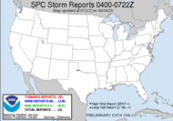
MANY OF THESE STORMS WILL BECOME STRONG TO SEVERE AND BE CAPABLE OF PRODUCING DAMAGING WINDS IN EXCESS OF 60 MPH AND EVEN TORNADOES. SPOTTERS AND EMERGENCY MANAGERS ARE URGED TO MONITOR THE WEATHER AND LISTEN FOR THE LATEST UPDATES ...INCLUDING ANY WATCHES AND WARNINGS THAT MAY BE ISSUED. SQUALL LINE MIGHT INTENSIFY AND BECOME INCREASINGLY SURFACE-BASED AS IT REACHES THIS ENVIRONMENT LATE TONIGHT/EARLY THURSDAY. SHORT LINES OF SCATTERED STORMS MAY ALSO FORM AHEAD OF SQUALL LINE IN STRENGTHENING SLY FLOW ALONG THE GA/SC/NC CSTL PLN. THESE STORMS...AND EMBEDDED SUPERCELLS/LEWPS ALONG THE SQUALL LINE...MAY YIELD ISOLATED TORNADOES GIVEN INTENSITY OF LOW LEVEL SHEAR AND LOWERING LCLS.
MCC's, tornadoes and hail in Alabama, Mississippi and the panhandle... this is a monster of a storm!!! I really wish that it were getting here sooner, storms at night are not only dangerous to chase, but they are bad for the people they impact. People are asleep when they hit, so much more danger of being hurt because they aren't watching the TV, listening to the radio, seeking shelter. I, for one, plan to be up, watching, listening... We are in a moderate risk area, but just barely... most of the action probably to occur to the west of us. It gives me chills to think about it.
I have a dental appt. today... Fun. It shouldn't be bad, just a cleaning. Nothing will get me down... we've got weather brewing...
Toodles... I'll give updates as it approaches...
~Dewdrop
Wednesday, November 15, 2006
Something brewing in them thar hills...
Labels:
Moderate Risk
Subscribe to:
Post Comments (Atom)


No comments:
Post a Comment
Dew comment, please...