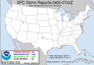
 Lots of tornado reports in LA, AR, MS, KS... Damage to lots of structures, damage swath a 1/4 mile wide, cars in trees, lots of hail. Welcome to severe weather season 2007. The time for SDS is officially over. This has been a big one, so far. Right now, things seem to be slightly settling down out of the line, compared to what it was anyway... tornado warning up now by the MS, AL line. It'll track through AL tonight creating who knows what kind of havoc while people sleep, some likely oblivious to its existence, many without weather radios... God be with them.
1011 PM CST SAT FEB 24 2007
AREAS AFFECTED...MS AND AL
CONCERNING...TORNADO WATCH 33...
VALID 250411Z - 250515Z
NUMEROUS EMBEDDED SUPERCELL STRUCTURES AND BOW-TYPE FEATURES MAKE UP A MORE EXTENSIVE SQUALL LINE THAT EXTENDS NE-SW ACROSS THE TORNADO WATCH FROM NWRN AL... SWWD INTO SRN LA. OVERALL LINE APPEARS TO BE SHIFTING ESEWD AT ROUGHLY 20KT...WITH MUCH FASTER INDIVIDUAL STORM MOTIONS.  From our local friendly forecaster, Kelly: THUS...THE ONLY REMAINING CONCERN WILL BE INSTABILITY. THE MODELS ARE INDICATING SOME INSTABILITY...MAINLY CAPES IN THE 500 TO 1000J/KG RANGE OVERNIGHT...WHICH ALONG WITH ALL THE FORCING THAT IS ONGOING SHOULD KEEP STORMS THAT ARE OUT THERE NOW CONTINUING. LINEAR EXTRAPOLATION OF THIS LINE SHOWS ARRIVAL INTO THE WESTERN CWA AROUND 4 AM CST. HOWEVER... THERE IS SOME CONCERN THAT IN THE STEADILY MOISTENING AIRMASS ALONG THE GULF COAST THAT SOME SHOWERS AND THUNDERSTORMS WILL DEVELOP AHEAD OF THIS MAIN LINE AFTER MIDNIGHT CST. (7 AM EST) WILL BE WEST OF THE APALACHICOLA AND CHATTAHOOCHEE RIVERS. THEREAFTER...THE THREAT WILL SHIFT EASTWARD INTO THE FLORIDA BIG BEND AND SOUTHWEST AND SOUTH CENTRAL GEORGIA. I plan to sleep with my weather radio and set my alarm clock for around 6:30 to check and see how things are going. My house phone is not working still, so I will rely on cell phone totally. Looks like a potentially exciting morning ahead. To chase, or not chase... we shall see. It's a nice strong squall line that has formed ahead of that front. If we get sufficient moisture up this way and the CAPES hold true to the models, it could be something worth chasing... 7 AM though... doggone. That's not far out. I'd better snuggle up with that weather radio and crawl into bed.
All you chasers out and about (or planning to be) with this one, stay safe, please. You shouldn't chase faster than your guardian angel can fly, you know...?
~Dewdrop
Sunday, February 25, 2007
To chase or not to chase...
Subscribe to:
Post Comments (Atom)


You have a great website and very imformative. Am impressed. Keep up the great work. Will visit often.
ReplyDeletecbmams
cbmams (Cumulonimbus mammatus?),
ReplyDeleteThanks for stopping by. Glad you like the site. I'll keep the blog going. I enjoy it.
Thanks for the compliments.
~Dew