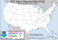
 Those storm bands are dropping some good much needed rain, some strong winds (LL called this morning to talk about the rain and howling wind last night), and, of course, a possible tornado. The panhandle looks to be the main target today, but given it's proximity to here, I expect to see some action here today. It'll be here and there, so I will need to keep an eye on radar. It is highly dependent upon what 93L does.
 I posted earlier in the week about the graphical hazardous weather outlook feature being added to the NWS site. Currently, it is not fully deployed, but expect that to be out there on Monday. Currently, there is a fabulous training presentation posted on their site that Kelly made to get people familiar with the new product.
It's Friday, and I don't even have any yard work to do!!
Toodles,
~Dewdrop
Friday, September 21, 2007
We might eventually have Jerry...
Subscribe to:
Post Comments (Atom)


Look out for the isolated tornadoes! Sounds like a good chasetunity. Charges those batteries and make sure your memory card is empty!
ReplyDeletehttp://alabama-weather.blogspot.com/2007/09/we-finally-have-subtropical-depression.html
Yahoo!!!
ReplyDelete