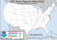
Well, the day is here, and so is the squall line (not terribly impressive), almost. Wind has been steadily increasing throughout the morning, with some strong gusts tossing my van this way and that on my way to the office this morning. As I type, gusts of wind are slapping the windows. The SPC has issued a Public Severe Weather Outlook, mostly outlining the Carolinas as the area that should anticipate the brunt of the storm today.
Since certain individuals, who shall remain nameless, don't seem to believe that the Dewvoid is dead, I have prepared this brief radar summary of recent squall line behavior. Certainly, this storm is not all power and potency at this point this morning, and yes, the biggest threat exists well to the northeast out of this event. Sure, there is no indication of rotation at the moment, but... BUT the intensity has grown on its approach to the area, my area... this is something I have never had the pleasure of experiencing, a storm actually intensifying as it approaches my neck of the woods. Yes, folks, the pesky Dewvoid is dead! Keep those weather radios turned on... anything can happen.

 The sky has turned to a solid deck of stratocumulus, passing rapidly by... I am not thinking much will happen here. We should get some significant rain, and we might get some lightning, which I would love to shoot, just for the sake of capturing daytime CG. I don't feel strongly that this event will be much like last Tuesday's, when I had the rare pleasure of seeing a rotating wall cloud and funnel cloud very nearby, but we are still in a drought... so rain (in theory) is a good thing. I just wish there was more time between storms to let the river drop back down. We've had a significant drop in the beaver population locally, as they have ventured out by the road with the river being so high. I haven't felt inclined to stop and photograph road-kill, but I have seen many beavers that met there unimely demise as their run-in with motorized technology "did them in"... that's since the river hit flood stage.
Oh, speaking of last Tuesday though, (which the guys have posted their public information statement about...) bf and I stopped on Friday by the area that had all the snapped trees in Hahira after the storm Tuesday, and I snapped a few shots on the other side of the road, where I wasn't able to stop the other day. 
 Then, we came across some geese that were chilling by a pond that once was gone but now is found.
  I got an email from Chris Collura yesterday containing some pics of "fast ice" portions of Lake Michigan in the dead of winter. Brr... In the email, he actually invited me to come on up to "cool off"... We all know what happens to Dew in cold weather... thanks, Chris, but I think I will pass, appreciating your pics in the comfort of warm south Georgia... great pics though...
The "cliffs" you see are not sand or rock, but pure ICE ... The sand color is simply from the winds kicking up sand during storms ... Pretty surrealistic.

Fast ice is the ice flows that form near the shore in arctic conditions, and can be many feet thick ... Note the crevasse in one, I am over 20 feet above lake level!
 Thanks for sharing that, Chris! It's good to appreciate that stuff from afar. ;O)
The weather is almost here. Let me keep an eye on radar. I will let you know if anything exciting happens.
10:30 AM Update: The worst of it is on top of me... no lightning. Oh well... there is always next time. :O)
12:20 PM Update: A tornado watch was just issued... to my north... one to my west and one to my north... nothing here... storm falling apart where I am... hmmm... I guess I should be fair and post the Mesoscale Discussion that Jeff and I are referencing. It does reference a possible round 2 for severe weather later in the afternoon, and places me smack dab in the middle of it that area. This is expected as the upper trough dives down to see what it can do. Expect that to occur around 4PM. Though cloud cover will limit instability, they say, well let me just quote them:
 UPPER FORCING AND AN INFLUX OF RICHER MOISTURE ON MODERATELY STRONG SOUTHERLY LOW-LEVEL FLOW...CHARACTERIZED BY MID/UPPER 60S SURFACE DEW POINTS MAY COMPENSATE. IN THE PRESENCE OF STRENGTHENING DEEP LAYER SHEAR AND SIZABLE CLOCKWISE CURVED LOW-LEVEL HODOGRAPHS...THERE WILL BE A RISK FOR TORNADOES...IN ADDITION TO DAMAGING WINDS...WITH THE EVOLVING CLUSTER
 Toodles,
~Dewdrop
Tuesday, March 04, 2008
Proof of the death of the Dewvoid
Subscribe to:
Post Comments (Atom)


Sitting on the FL west coast feeling the burn now from the blow off cirrus deck. Crossing fingers for new development east of current convective mess in the Gulf.
ReplyDeleteI've got my fingers crossed for you, Jeff... but I wouldn't get my hopes up too high, if I were you.
ReplyDeleteNew WW for your area possible as upper trough diggs to your west. You might see another round.
ReplyDeleteAs for me, I 'm having more fun watching runaway shopping carts in the parking lot I’m in.
I don't know, Jeff. I am not seeing it... I just read the MD issued that includes my area, but I just don't know. I think it will be much further to the east of my location.
ReplyDeleteRunaway shopping carts??? Fun times. ;O)
Holy cow... I leave for Disney for one weekend, and return to your blog to find it filled with total awesomeness of pictures, info and a funnel cloud video! ROCK ON!
ReplyDeleteCourtney :o)
Ode To The Death Of The Dewvoid:
ReplyDelete"YIPEEE!!!!" :-)
The Public Information statement leaves me with no change to my thinking last week. There were three tornadoes. Thomasville, Clyattsville, and Hahira. That's just lil' ol' me talking, though.
ReplyDeleteNotice they did not show the velocity images of the NEXRAD when strong areas of rotation were shown, including a few TVS's......
Sorry, I had to beat the dead horse one more time...
Again I say, awesome pictures! I would love to go and explore that icey landscape. I also love the wildlife shot you got. You are truly awesome!
ReplyDeleteIt Lives!!! (Eviul laugh)
ReplyDeleteCourtney, Thanks, girl! Glad I could keep you entertained as you came off your "magical" high. Hope you had a magical time... I expect to see pics.
ReplyDeleteSteve, A Happy Dew Dance is definitely in order. "YIPEEE!" indeed! :O)
Mike, I addressed this one in my blog today... it was worth mentioning.
Rick, I am confused... what is it you want, exactly???
ReplyDeleteMan, my comment posting mechanism is all out of whack. Annie, thanks... I will let Chris know that his pics were appreciated. Thanks, also for the awesome complement regarding my awesomeness... you are truly awesome yourself!!
ReplyDelete