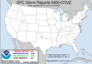
 with only 6 tornadoes being reported, but there was at least one large tornado reported in Breckenridge, TX, over the course of last night's severe weather outbreak. The National Weather Service office in Fort Worth, TX plans to survey the damage today, according to the graphic below. Unfortunately, they are currently still dealing with severe weather with an active tornado watch as the now squalled tail of that same system moves through the area.
 Here are the reports (or where you can expect to find photos and first hand information) about yesterday's storm:
Ken Reynolds's Chase Account
Tony Laubach's Chase Account (not up yet, but he saw the Abilene tornado)
David Drummond's Chase Account (not up yet)
Brian Emfinger's Chase Account
Verne Carlson's Chase Account
Amos Magliocco's Chase Account (not up yet, but I saw his spotter icon out there in the heart of it)
Scott Blair's Chase Account
Chris Collura's Chase Account (not up yet, but I know he was supposed to rendezvouz with Tony)
Jeff Gammons's Updates from Chasers in the Field The moderate risk for severe weather has shifted slightly eastward for today, encompassing most of Arkansas, northern Louisiana, northern Mississippi, western Tennessee, western Kentucky, southwestern Missouri, southern Illinois, and southern Indiana...
 COMBINATION OF INCREASING INSTABILITY... SBCAPE TO 2000 J PER KG... RICH MOISTURE SUPPLY... 850 DEWPOINTS AOA 14C... EXISTING STRONGLY-SHEARED ENVIRONMENT... AND ABSENCE OF STRONG, DEEP LINEAR FORCING FOR ASCENT MAY SUPPORT A FEW LONG-LIVED DISCRETE OR SEMI-DISCRETE SUPERCELLS WITH A THREAT FOR STRONG TORNADOES.
Already, I see a tornado warning on a discrete cell moving into southwestern Arkansas and in southeastern Missouri. It will be another busy day.
Safe chasing...
~Dewdrop
Thursday, April 10, 2008
Not out of the woods yet...
Subscribe to:
Post Comments (Atom)


Crazy busy. Convection will be swelling kind of like the oddly looking foam in Dew's macaroni pot when cooking on high.
ReplyDeleteLOL! You liked that analogy, did ya? I'm cracking up!
ReplyDeleteLOL! funny stuff!
ReplyDeleteJust chatted with Chris, they are heaidng east out of Texas into todays target area.
They see anything yesterday?? Who is he chasing with?
ReplyDeleteBest wishes, Chris. Stay safe.
Tim S., Tony L, Verne C, for yesterday. As for today not sure yet, but they were on the Breckenridge cell. Pick on my blog and more to come.
ReplyDeleteYeah, I knew Tony had mentioned he was hooking up with Chris. I saw Verne and Tony on Spotter Network. I saw the pic. I look forward to more updates.
ReplyDeleteJust a note, I believe that Chris and his crew passed us just east of Abilene. Everyone seemed to be headed for the storm that eventually hit Breckenridge, but Ryan and I decided to stop for data instead of following the sky. That decision will haunt me for a while, I think. Also, I'm pretty sure at least one of the Outlaw Chasers passed us up in Decatur, TX, later that evening. Seems like everyone was out there yesterday!
ReplyDeleteI thought so too, looking at ALL THOSE SPOTTER ICONS!!! It must have been wall-to-wall chasers! Sorry, you missed out due to your stop. I had a similar experience in SD, when I missed the tornado that EVERYONE else saw. We were about 30 minutes late... sigh... Here is a shot that Scott Blair got of it, best shot I've seen... grumble.
ReplyDeleteNot to pour salt in the wound, but there is a much better shot of that one here: http://www.chaseday.com/ Trust me, I feel your pain!
ReplyDeleteYeah... thanks for that link, Ken... shaking my head. Here is a link to more pics of the tornado that I should have had in Kyle, SD on June 6, 2007. I was SO close!!!
ReplyDelete