 Sky Watch Friday post time!!! (Please visit Tom's blog to participate.)Today, in honor of severe weather season, I want to cover something that is sometimes mistaken for tornadoes... SCUD CLOUDS!
 This is actually picturesque scud that was associated with a little bit of a rain shower that was heavily illuminated by the setting sun, not in any way associated with a severe weather event.
*Scud (or Fractus) - Small, ragged, low cloud fragments that are unattached to a larger cloud base and often seen with and behind cold fronts and thunderstorm gust fronts. Such clouds generally are associated with cool moist air, such as thunderstorm outflow. ~source, David Drummond's really awesome spotter guide
Sometimes, especially during a severe weather outbreak, scud can be quite deceiving, being drawn into the inflow of the storm and consolidating and organizing to form a wall cloud, making it look VERY MUCH like a funnel cloud... a funnel cloud is a funnel cloud because of its near or vertical rotation. Scud does not rotate.Tornado/Funnel Cloud Look-Alikes
Here is a site that I found that has some non-tornadoes to look at...
A number of features (both natural and man-made) can bear a resemblance to a tornado or funnel cloud. Some of these natural features include rain shafts and scud clouds. If a suspicious looking cloud formation is observed, watch it for a minute or two. Look for organized rotation about a vertical or near-vertical axis. ~source
The wall cloud that I witnessed on Wednesday was drawing in a tremendous amount of scud as it passed over on the interstate. I was closely watching it as I reported it into the National Weather Service (as a trained SKYWARN spotter, I report weather that can be helpful to them in making assessments and decisions about whether or not to issue warnings), as significant scud being drawn into a wall cloud that had just passed over the interstate on the tornado warned cell. I told the forecaster that I did not note any rotation on the wall cloud, and without rotation, scud is just scud. Evil looking? Perhaps. Dangerous? Nope. Here are some of the better scud shots from my chase on Wednesday. They were going though various stages of consolidation, forming and re-forming the wall cloud with this supercell.
 See how it might look like a funnel cloud. With it being tornado warned, I would imagine some people were really thinking so...
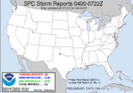
Well, you see in yesterday's post that weather got exceptionally wild yesterday with a total of 47 tornado reports (and the number keeps climbing) in Colorado, Wyoming, Kansas, Nebraska and California... CALIFORNIA?!!!! WHAT?! Sure enough... see that little red dot with accompanying green dots over there in southern California? That's a tornado report and hail... near March AFB in California. Of all the crazy things... So much destruction occurred yesterday... it's unreal. I know it's difficult recovering from such a traumatic experience. The horrible reality is striking me... it ain't over. (I am not usually one to use the non-word ain't, but it seems so appropriate here.)
  This beast of a storm is forecast to kick back up today, with a moderate risk for parts of Kansas, Nebraska, and yes folks Colorado... AGAIN. I know residents in the areas destroyed probably have frazzled nerves. I can't imagine digging through debris of what used to be my home or my business, trying to wrap my mind around the loss, while all the while knowing that more is yet to come. How awful! Wall to wall storm chasers are once again watching this event, converging throughout the plains, ready to capture photographs, videos and offer valuable feedback and real time observations for the National Weather Service to use to help protect life and property. Of course, with the moderate risk comes the Public Severe Weather Outlook. The Storm Prediction Center anticipates a few strong tornadoes.
Slight risks hatched out for the next few days... at least the location is shifting... some.
1525 EDT Update: PDS Tornado Watch... again. THE NWS STORM PREDICTION CENTER HAS ISSUED A TORNADO WATCH FOR PORTIONS OF:
Happy Friday!
PARTS OF EASTERN COLORADO
LARGE PART OF WESTERN KANSAS
PARTS OF SOUTHWESTERN NEBRASKA
EFFECTIVE THIS FRIDAY AFTERNOON AND EVENING FROM 215 PM UNTIL 1000 PM CDT.
...THIS IS A PARTICULARLY DANGEROUS SITUATION...
DESTRUCTIVE TORNADOES...LARGE HAIL TO 4 INCHES IN DIAMETER...THUNDERSTORM WIND GUSTS TO 80 MPH...AND DANGEROUS LIGHTNING ARE POSSIBLE IN THESE AREAS.
Update: Though the accompanying map doesn't support it, it appears that there were over 60 tornado reports yesterday.
Have a great one!!!
~Dewdrop
Friday, May 23, 2008
Scud... severe weather update...
Labels:
sky watch Friday
Subscribe to:
Post Comments (Atom)


Those last two are dark and telling aren't they!
ReplyDeleteAs always - nice informative post with wonderful images.
Very interesting post thanks. Those clouds really look scary!
ReplyDeleteYes, Carletta, with the tornado warning looming, and it's proximity to moderate traffic and populated areas, it was quite ominous. Could have been bad if something had started rotating. Thanks.
ReplyDeletePatty, thanks. It was quite intense.
Great photo shot, No i have a question, I did not know that Colorado has tornado's is this common or have i not been paying attention?
ReplyDeleteRough times for those folks but it is a playground for the chasers....
ReplyDeleteLilli, Great question! I would like to thank my chase team member Mikey for providing a link to this information on one of the team blog entries. Colorado, you will probably be surprised to learn, is ranked number 9 for states having the most tornadoes since 1950, with 1,738 tornadoes from 1950 to 2007. A link to the chart and other related information is located here (click here). An interesting sidenote is that they are not on the top 20 list for fatalities, injuries or dollars.
ReplyDeleteMike, very true.
ReplyDeleteGreat storm. Did you see the video from the Denver tornado. It was massive
ReplyDeleteThanks, Tommy. Yes, it was a massive wedge, quite impressive. I have it linked below.
ReplyDeleteMercy me, Ms. Dewdrop. Not only do you take great photos, but your site is most informative. As a result of today's post, I've added something else to my vocabulary - scud clouds. I learned about crepuscular rays here last week and have been watching for them everywhere. Now I'll have to be on the alert for scud clouds; probably a good thing since I live in a tornado state.
ReplyDeleteThis is a wonderful series. Those clouds sure do tuck your world in!
ReplyDeleteHi Dew.. I see the word 'scud' mentioned a few times... I will know just what it means now... thank you.. I really enjoyed your accout of the storm yesterday.. :O)
ReplyDeleteDewdrop: you always have such interesting posts.
ReplyDeleteYou always bring us great posts with fantastic photos!
ReplyDeleteInteresting post, excellent picture, excellent done.
ReplyDeleteInteresting blog - your pictures are awesome. And the top picture for SWF is very beautiful!
ReplyDeleteInteresting shots. The last two do look somewhat spooky.
ReplyDeleteWe had 4/10th's of an inch of rain thoday. Might get some more which we need to water our vegetable garden.
Scud really DOES look a bit like funnel clouds. I'll be watching the skies now for scud, paying particular attention if the clouds seem to be revolving.
ReplyDeleteWhat a terrific photo! Seeing a cloud that in any way resembled a tornado forming would spook me silly.
ReplyDeleteGreat pictures from an expert! :)
ReplyDeleteDramatic look.
We haven`t had any rain in several weeks here in the Western part of Norway. It`s dry. The earth thirst for water. But, not me. I`m painting the house. ;)
Have a nice weekend!
Pat, yes, definitely a good idea for you to be on the lookout for rotation in them where you are. I thank you for your compliments, and I am so glad you are learning.
ReplyDeleteSandy, Thanks so much. Tuck my world in? I'm not sure I have heard that expression before.
Tom, I really appreciate you, such positive feedback all the time. I hope I will get to meet you one day.
Fishing guy, Thanks!! Love your kissing squirrels.
Quint, Thanks. I'm glad to do it and share what I am so passionate about.
Daniel, thanks, thank you and thanks bunches.
Chanpheng, Thanks. I really appreciate that. Ma Nature does beautiful work. God is a great artist.
Andrea, It was spooky driving into it, not knowing if a funnel would drop over the interstate and descend to a tornado. I hope y'all get more rain. I know you can definitely use it.
My EG tour guide, the rotation of the column is a key factor. Be very watchful. Scud can be cool to watch and imagine the shapes are different objects.
Musings, It is spooky for a reason. It looks dangerous as a warning that the potential exists. If you ever see that kind of sky, you should make sure your weather radio is on.
Ida, an expert?! I don't think so, but thank you for the compliment. I have so much left to learn. I have only been in storm chasing for two years, and though I have learned so much, I feel like there is a lifetime of information to learn. I hope you get your much needed rain. Enjoy painting.
I've never seen a tornado cloud but if I do we will find out how fast Dot can run to shelter.
ReplyDeleteGiven the choice, I'll take an ole scud anyday over an actual tornado!
ReplyDeleteDot, yes, the best thing to do is get into a secure places, low lying, intererior rooms, as fast as you can.
ReplyDeleteAnnie, That is most definitely most people's choices. In fact, given the death and destruction, I am in that group.
Thanks for this update Miss Dewdrop... :) The pictures are great! I like the link you found regarding the non-tornado sites. Clouds could really be deceiving. The pictures on that site really looks like a tornado.
ReplyDeleteThanks again for sharing and for this update. :)
Glad to share it, Ice. I am glad that you found the links helpful. I found that part of SKYWARN Spotter training very interesting. In a few of my classes, they took it a step further, showing us storm damage, and asking us if it was tornado or straight line wind damage. Very cool. You're welcome.
ReplyDelete