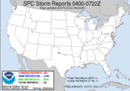
 This is a capturefrom 5:50AM EDT. Have I mentioned how much I hate nighttime events?! Tornado Watch just issed for my county. Meso Mike is visiting his mom up in Byron, GA. He just experienced what sounds like a straight line wind event.
  I am currently waiting on daylight, talking with Meso Mike. He's shooting lightning after his (what sounds like a) straight line event. I am currently listening to firetrucks up in Byron after they have reported thunderstorm wind damage, and he is without power.
0448EDT: Public Severe Weather Outlook... looks like we'll get the line at the tail of this low. sigh... another squall.
This the SPC storm reports, up near where Meso Mike is...LIZELLA, BIBB COUNTY, GA
The same cell that produced thunderstorm wind damage up near him, did this:
POSSIBLE TORNADO DESTROYED HOME ON WATERS EDGE RD NEAR SOUTH SHORE OF LAKE TOBESOFKEE. LOTS OF TREES AND LINES DOWN. INSULATION STREWN ABOUT.DUBLIN, LAURENS COUNTY, GA *** 1 INJ ***
They are calling it a mesolow, that went through the Macon/Byron area, with winds in excess of 100mph... now you see why I referred to him as "Meso magnet Mike" for a while...
POSSIBLE TORNADO DESTROYED SEVERAL HOMES AT US 441 AND EVERGREEN RD. NUMEROUS TREES DOWN. UNKNOWN NUMBER OF INJURIES HAVE BEEN CONFIRMEDMesolow
0730EDT Update: Currently a potential tornado near Americus, GA...
(or Sub-synoptic Low) - A mesoscale low-pressure center. Severe weather potential often increases in the area near and just ahead of a mesolow. Mesolow should not be confused with mesocyclone, which is a storm-scale phenomenon. A tornado warning in Crisp and Sumter counties. Here is the 0746EDT capture...
IMPRESSIVE MCS/APPARENT DERECHO CONTINUES TO RACE EASTWARD AT 60-65 KT ACROSS CENTRAL INTO EASTERN GA EARLY THIS MORNING. THIS MATURE/WELL-ORGANIZED SQUALL LINE CONTINUES TO EXHIBIT CLASSIC REAR INFLOW/VERY STRONG VELOCITIES
Jeff Davis tornado warning 0805 EDT: 0820EDT: The National Weather Service in Tallahassee is planning to launch a special radiosonde to see what the atmospheric conditions are and whether or not my tornado watch is warranted. Still experiencing strong southerlies. If we get any moisture feed off the Gulf, I think things might stand a chance at firing down in my neck of the woods, but it seems dry at this point. This is not a chaseable event as it stands. Fast mover... dropping tornadoes randomly... rain wrapped... strong dangerous derecho winds... just not worth it.
 The SPC Outlook for us has been updated... the moderate risk has been moved over to the coast... well, that was without a crystal ball... my moderate risk is gone.
  They have decided to continue the tornado watch as the actual cold front approaches.
0951EDT, DARIEN, MCINTOSH COUNTY, GA
A PORTION OF THE ROOF IS ON THE INTERSTATE?!
POSSIBLE TORNADO GATEWAY BUILDING DETROYED. PORTION OF THE ROOF IS ON THE INTERSTATE 95 NEAR MILE MARKER 50.
More tornado reports (EF-2's in GEORGIA!!): 1. 0910 MORROW, CLAYTON COUNTY, GA
EF2 TOUCHDOWN JUST EAST OF I-675.APPROXIMATELY 100 YARDS WIDE. 1 HOME WITH 2ND FLOOR TAKEN OFF. MANY HOMES WITH DAMAGE IN ELLENWOOD.
2. 0955 MACON, BIBB COUNTY, GA
EF2 TORNADO. SIGNIFICANT DAMAGE TO BUSINESSES AND MACON STATE COLLEGE. 2 BUILDINGS DESTROYED. NEARLY HALF OF THE TREES ON MACON STATE COLLEGE CAMPUS WERE EITHER BROKEN
1446EDT Update: Another tornado watch just issued for my neck of the woods...
More updates to come...
~Dewdrop
Sunday, May 11, 2008
Tornado outbreak today??? We shall see.
Subscribe to:
Post Comments (Atom)


When I woke up this morning I was surprised to see the action so far southeast already. It really hauled overnight. When I went to bed last night it wasn't even in Alabama yet! Not much chance of any action up here today, easterly winds have things cool and cloudy. I'll need to drive around 5 hours south to get into any unstable air. Not in the cards for me on Mothers Day. 21 deaths yesterday is really sad, but we saw it coming.
ReplyDeleteSCM
It hauled like crazy. I can't believe how fast it is moving.
ReplyDelete21 deaths... awful. Seeing it coming doesn't seem to make that any easier to swallow. My winds just now, suddenly stopped. Weird. This storm is scary.
The more I watch the loop, I'm starting to think you may get some good action. That cold front is still way behind this Echo line. The storms on the tailing SW side of the Echo are starting to seperate and really have a nice SW to NE tilt to them. That echo is gonna pass to your NE and clear out, but the tail end storm cells could get real interesting as they ride into the unstable air near your area. I think you could be in for some action. It's not over yet.
ReplyDeleteSCM
I've got that same inkling Mikey. I am watching the echo get closer and closer to me. That part will miss me, but as the tail of it loops in and feeds some of the Gulf, I could easily get some initiation. I am keeping a close watch. The wind here started back up almost immediately after I posted my last comment, sometimes so loud, it sounds like thunder.
ReplyDeleteNew cells are quickly going up to your west. Looks like they could eventually form into a new line and come through your area. Amazing how fast those cells are going up!!! The Low Pressure core over Indianapolis looks like a tropical storm!!! Wow!
ReplyDeleteSCM
I'm watching that cold front approach. We have some beautiful heating going on right now. In fact, the sun is showing its stuff. We should have some opportunities as the cold front approaches. I am thinking that is my best chasetunity, the spin-offs ahead of the actual cold front. The air is thick here, ripe for action... show me the weather!
ReplyDeleteI was watching that low over Illinois/Indiana. I had just told Rick that it looks like a tropical storm! Funny!
Very sad news about those deaths and injuries. Sadly this is becoming one of the worst years for that in a long time.
ReplyDeleteIs the atmosphere going to get enough sun to destabilize again for you Dew? Vertical shear looks very strong!
ReplyDeleteSCM
Mike, that is very sadly true. What a horrible year it has been for that, such tragedy.
ReplyDeleteMikey, It has been sunny for quite some time now. I think there has been more than adequate heating to allow for destabilization. It looks like that last line is right there at the tri-state area with some of those cells wanting to start firing up. If they stay discrete, I might get a brief piece of it.
A friend told me today that a person she knows had gone to get into her pickup truck and then a twister hit. It lifed her up and spinned her truck around in the air and then dropped her back down. Her moble home was torn in half. Her bf was asleep in the back bedroom. No injuries at their home, very lucky. This happened in Macon.
ReplyDeleteHappy Mother's Day, T
It really did a serious damage on the houses... :( Plus 21 deaths... :( That's just sad... I'm glad that my friends didn't get hurt during that severe weather...
ReplyDeleteHappy Mother's Day, Teresa. Thanks for the sweet thank you card. You are very welcome. Sad about your friend's friend up in Macon. I am so glad they are ok, but I know she must be severely traumatized. I can't imagine what that must have been like.
ReplyDeleteJessica, Horribly sad. It's unimaginable.