My SKY WATCH FRIDAY POST IS BELOW...
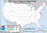
I want to put out a tropical update... cause I love tracking this stuff.  Well, as you can see in the graphic above. We still have the 1,2,3 PUNCH, the series of tropical systems moving this way.
BRIEF SUMMARY The unfortunate news for the Carolina coast (**and this is just my own assessment**) is that Hanna appears to be really pulling in strong convection and actually forming an eye. With this kind of organization, the likelihood increases that Hanna will make it to hurricane strength before the anticipated landfall along the South Carolina coast. I do see her as more significant than she has been letting on though, and I think the forecast of a TS landfall will be amended at the 11AM. Again, that's just me. The official forecast doesn't come from me.
 What can I say about Hurricane Ike? That impressive looking hurricane has taken a beating under the northeasterlies and has still maintained major hurricane strength, though he's extremely bottom heavy. Please don't write him off though. He may lose strength over the next couple of days in this harsh environment, but signs definitely point to intensification back up to major hurricane after the rough period. If Ike can steer clear of Cuba, he is liable to become an extremely dangerous hurricane and seems to have his sites set on southern Florida. The national Hurricane Center is urging people not to get hung up on the 72 hour forecast track and beyond because truly ANYTHING can happen. The models have not really come into alignment at all... this is not a good thing. Basically... everyone needs to keep an eye on this fella.
 Tropical Storm Josephine is not very convectively sound, but she has intensified and has a pretty spin about her. She is most likely destined for fishhood... which I think the east coast , Cuba and the Bahamas are probably happy to breath a sigh of relief about. Enough already. The models are pretty consistently putting this one out to sea.
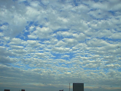
The cool thing is that with Hanna's large size, her arms of convection are seen here, not really solid convective bands, but some stratocumulus was moving in over us with this sky on the edge... how pretty, huh?  I love altocumulus when it's so beautifully blue behind it.
11AM Update: Regarding Hanna: THE NEW FORECAST TRACK IS ADJUSTED A LITTLE TO THE LEFT FOR THE FIRST 36 HR TO ACCOUNT FOR THE INITIAL POSITION. THE INCREASED ORGANIZATION SUGGESTS THE POSSIBILITY OF STRENGTHENING BEFORE LANDFALL. NONE OF THE GUIDANCE INDICATES THAT HANNA WILL REACH HURRICANE STRENGTH PRIOR TO LANDFALL...ALTHOUGH THIS CANNOT BE RULED OUT.
 Also, the new trajectory for Ike is particularly interesting... it brings things a lot closer to the possibility for the Tally "Doomesday scenario"... of a Big Bend landfall to happen...
 Great googaly moogaly. Official Disclaimer:
 IT CANNOT BE REPEATED ENOUGH THAT FOUR- AND FIVE-DAY TRACK FORECASTS CAN HAVE SIGNIFICANT ERRORS...AND COMBINED WITH THE FACT THAT THE MODEL SPREAD IS STILL NOTABLE BEYOND 72 HOURS...ONE SHOULD NOT FOCUS ON THE EXACT TRACK.
Have a lovely weekend. Carolinas, hang on tight.
~Dewdrop
Friday, September 05, 2008
Tropical Storm Hanna almost upon us, with Hurricane Ike hot on her trail....
TROPICAL STORM HANNA
HURRICANE IKE
TROPICAL STORM JOSEPHINE
Subscribe to:
Post Comments (Atom)


Great altocumulus shots, Dew! One of my fave types!
ReplyDeleteYesterdays max temp at OSNW3 was 59.5, the lowest max temp since Jun 3 when the temp maxed out at 58.1. 0.54" of precip from the remains of Gustav at OSNW3. Check out the radar loop (6Mb) http://www.theplayerstour.net/osnw3/photos/2008_Gustav.gif
Thanks! I like it too... the blue colors between were amazing, unreal. Love the loop you've created.
ReplyDeleteAn easy way to track Ike is with http://www.USAMediaGuide.com. It has a special section of links to Ike's projected path, National Hurricane Center and local news coverage, hurricane preparation tips, live streaming webcams, and other Ike-related stuff.
ReplyDeleteHarry, Thanks for the link. I really appreciate it. Interesting news site.
ReplyDeleteHi Dew... :O)
ReplyDeleteDid you think I'd forgotten about my favourite Storm Chaser..
I'm well behind with my visits and I'm not even going to try and play catch up.. but thought I'd drop by the blogs I've been missing... You cloud and blue sky is awesome.. and the reports of those hurricanes makes great reading.. I been watching the news when I can nd following what the worlds weather as been up to... we have flooding over here with all the rainfall which is making the news ... and we have more... lots more rain forecast.
On that not so bright note I'll leave you and go see your Sky Watch post...
Hope alls well in Dews World...
Tom
Tom, So sweet of you to drop by with a thoughtful note. I knew you hadn't forgotten me. How could you possibly forget you favourite storm chaser. I appreciate that you missed me. Try to stay dry! All is fabulous in Dew's world... What about Wigley World?
ReplyDeleteI so dew have an eye on Ike - and have to say I always liked Tina way better than Ike anyway.
ReplyDeleteWas that you in the clip (red shirt?)
You dew stuff like that? Now tell me - did you dew survive? - I can't stand the tension...! ;)
Pretty cool! Ike won't be dewliciuos, of that I'm pretty sure.
From the current paths we'll be on his north eastern side. Yuk.
But we'll rough it out!
Cheers, Klaus
In what clip? What are you talking about, Klaus? I dew stuff like what?
ReplyDeleteI might get Ike if he comes on up to the big bend... no one knows what he has in store. I hope you dew well.
What an incredible shot! Just beautiful! I love all of the info you share about the coming storms. I try not to get too into it. but stay prepared and continue living as normal. Life is just easier that way for me. Happy SWF and a wonderful weekend to you! I will check back with you. You are very thorough!!
ReplyDeleteNow that's a real skywatch post!
ReplyDeleteMy Sky