MY SKY WATCH POST IS BELOW...
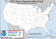
Yesterday, I watched severe weather dance all around me. I watched one cell in particular pass just to my south that had lots of rotation being exhibited. I watched it come up through north Florida... into Echols County as a severe thunderstorm warned cell and then enter Clinch County as a tornado warned cell. My weather radio sounded the alarm and blared the warnings. 
1543 7N OF FARGO CLINCH COUNTY,GA
Here are the screen shots...
TORNADO SPOTTED NORTH OF FARGO. TREES REPORTED SNAPPED.
 Yesterday's tornado was about 20 miles from me... chaseable... on a doggone Thursday!
Have a wonderful weekend!
~Dewdrop
Oh, btw, the Atlantic Basin is looking a little active again.
Friday, October 10, 2008
Just a quick update... Clinch County tornado
Subscribe to:
Post Comments (Atom)


No comments:
Post a Comment
Dew comment, please...