I AM UPDATING TO THE BOTTOM OF THIS POST...
Our first tornado warning has been issued, with a strong radar signature between Oklahoma City and El Reno, OK... Looks like a strong tornado potential here...

3:25EST Still looking strong...
HAIL REPORT
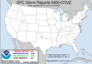
1522EST 2.50" 2 W YUKON, OK REPORTED BY BROADCAST MEDIA Another tornado watch has been issued for extreme northeastern Oklahoma and northwest Arkansas as the threat moves to the northeast. My friend in the Ozarks... be vigilant and watchful! Feel free to click on the graphic for retails.
3:50EST like the Energizer Bunny...
4:03EST: These look more impressive now than the one that is still tornado warned...
4:09EST, they are streaming live footage of the large tornado produced by the tornado warned cell... headed toward Guthrie, OK, near Waterloo, OK in Edmond, OK. Here is the link. Thanks, Alabama Mike!
4:13EST: Can I call em or what?! Yukon area, Oklahoma. Cars with people trapped inside and powerlines on them... bad day...
4:30EST: More...Langston, OK, headed for Stillwater, OK.
Another at Union City, 
4:40EST: Broadway and Waterloo, significant damage reported... serious hook presentation in the Langston, OK warning signature.
... and Yukon, OK...
Hail, the size of tennis balls being reported...
~Dew
Tuesday, February 10, 2009
El Reno/Oklahoma City, OK Tornado Warning, Yukon, OK, Union City, OK...
Labels:
tornado warnings
Subscribe to:
Post Comments (Atom)


No comments:
Post a Comment
Dew comment, please...