POST IS AT THE BOTTOM OF THIS POST!!!

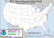
TORNADO REPORTSWell, it appears that the tornadic activity last night (starting just prior to 1AM and lasting through... what time did I post that???) was limited to an area of within 70 miles or so of my house. There was a report of an actual touchdown, just about
0545Z 6 S CAIRO GRADY COUNTY GA
CONFIRMED TORNADO WITH MANY TREES DOWN 6 MILES TO THE SOUTH OF CAIRO. SEMI-TRAILER TRUCK OVERTURNED. (TAE)
0605Z 1 S THOMASVILLE THOMAS COUNTY GA
WDIESPREAD TREES AND POWER LINES FELLED BY CONFIRMED TORNADO AT THE INTERSTION OF 319 AND PINE TREE ROAD. (TAE)
0620Z BOSTON THOMAS COUNTY GA
WIDESPREAD TREES DOWN THAT WERE TWISTED AND SNAPPED OFF. WIDESPREAD POWERLINES DOWN AND MANY ROADS IMPASSIBLE. (TAE)
0715Z VALDOSTA LOWNDES COUNTY GA
TORNADO TOUCHED DOWN ON VALDELL ROAD OFF OF HWY 41 IN VALDOSTA. (TAE)
 12:44AM:
 12:50AM:
 12:55AM:
 1:01AM:
 1:07AM:
 After the 1:07AM capture, I was watching it with a lot of analysis... not really paying attention to capturing, more in a protect life and property mode... it looks like it had lost its energy, but just as it approached my county (very close to me...) it started to rotate again, and it had a strong signature on the relative velocity. Just as I had made the decision to take cover, the weather radio alerted me that the Tallahassee Weather Service office agreed and were issuing a tornado warning for my area. Grabbed Mini-Dew, the dog and a mattress and we took cover, all the while getting texted updates from Mike and Rick, who were vigilantly watching on my behalf. Incidentally, it was our first time having to do that, and well, happy birthday Mini-Dew... as she shivered in my arms behind the mattress. While, we were under the mattress during our tornado warning, the SPC upgraded our Severe Thunderstorm Watch to a Tornado Watch... I had to chuckle... just prior to the 4th and final tornado, they saw fit to escalate the watch...
2:08AM (after it had passed) I don't have captured from when it touched down 3 miles to my south. I was a little busy:
 That's my report! Again, a HUGE THANK YOU to Alabama Mike and Rick for having our backs! The Southern Weather Brigade is a great team!
WHEW... aside from that, and now that my pulse is finally returning to normal... SKY WATCH FRIDAY time! Please visit Klaus, Sandy, Ivar, Wren, Louise and Fishing Guy, the team for SKY WATCH FRIDAY (click the word to link and participate!) Thanks to Dot and Tom, who were instrumental in the success of this blogging event. You should definitely come fly with us! In honor of last night's (well, this morning's) long tracking tornadic supercell. I thought I'd share a pic with you today of one of my favorite supercells, which produced my first captured funnel clouds (3 of them!)
 In this particular supercell, you see the mesocyclonic striation bands on the anvil which are an indication of strong rotation. You see the wall cloud on the right dissipating and feeding into the inflow of the newly forming wall cloud on the left. It was in the wall cloud on the left where 3 needle funnel clouds descended, while we were watching. It was amazing, and it was such a scenic opportunity. I can't wait to get back out there. This was somewhere in SD on June 6, 2007.
Have a great day!
~Dewdrop


Glad you all are safe. Rick absolutely nailed the location of that thing.
ReplyDeleteI'm so happy that you and Mini-Dew are safe. When the radio started going nuts about 2:30 this morning, I got up and started tracking it too. We got hit with some pretty strong winds down here in TLH, but nothing more than that.
ReplyDeleteThose supercells marching across AL and GA last night ... CRAZY!
Wow. An amazing day/night. I"m really surprised that the total number of tornado reports wasn't higher after it was all said and done. Glad you were on it and taking it seriously.
ReplyDeleteSCM
t goes to show that in the course of our weather pursuits that the Hunter of in this case the "huntress" can become the hunted. Glad to see that you , MiniDew and GTB and company are ok..It was a close call for us last night..
ReplyDeleteAnonymous post on the team blog...
ReplyDelete"Anonymous said...
Major damage US 319 about 1/2 mile south of Thomasville city limits. Severe damage to Baytree Estates trailer park in this area-several homes destroyed-large amount of uprooted and snapped trees. No deaths as of now (0330 hrs) Roadsigns along this area where flatted to the ground. Tornado also hit Grady county before making its way down US 84 to Thomasville, then onward towards Boston,GA. Daylight will def. show its path.
February 19, 2009 3:31 AM
Anonymous said...
Southwestern State Hospital was hit by the center of the storm. No patient or staff injuries but lots of building damage, downed trees and disabled cars."
February 19, 2009 5:01 AM
SCM: I think the final tally will be much higher on the tornado reports. Based on the video and damage reports I have seen from Alabama, there were several possible tornadoes, but none listed as such yet. Some of the videos are obvious. As far as i am concerned, I was in an EF0 yesterday myself. I'm looking forward to the survey reports.
ReplyDeleteI saw a report of a fatality in Ga. Very sad.
Think you had way too much adventure last night. I hope you get a good night's sleep tonight!
ReplyDeleteI'm glad you are ok. Tornadoes are so frightening. Beautiful skywatch shot. I love the total effect of the sky as well as the land below.
ReplyDeleteglad you are safe what an experience........love your photo. I always love your posts so informative.
ReplyDeleteGill in Canada
Scary times.Glad everything turned out ok. Sad about the fatalatiy, though. Hope there are no more.
ReplyDeleteGood shot, I like to see photos of these events but would rather keep my distance from them, as in states away, LOL.
ReplyDeleteGlad all is well with you and the family, Dew! That was a scary night. I have a friend whose family is in Thomasville; will have to check with her to see if everyone is OK.
ReplyDeleteSuper sky watch photo, BTW.
Good shot and scary times!It´s always interesting to read in your blog!Happy SWF!
ReplyDeleteIt is certainly look Dew-rific...that was a massive of clouds you captured there...
ReplyDeleteSUPERNOVA and SWEETPAIN
ANGELS IN MY LIFE
Dew: An interesting capture from an exciting time for you.
ReplyDeleteWow. That was an experience. I almost forgot what i came here for. Nice photography.
ReplyDeleteI thought I would try SkyWatch again. Not sure how far I will get before I tire out but will give it a try.
My Skywatch Post
Wow I am glad you and Mini Dew are okay. These types storms have been awful. I bet we are going to have an awful spring weather wise. Great photo you were able to take.
ReplyDeleteMe too are glad to hear that you are safe and sound! :)
ReplyDeleteThat was more than exciting!
Great shot!
Interesting. :)
Great skywatch contribution as always, keep em coming.
ReplyDeleteHave a great weekend!
Guy
Regina In Pictures
Fantabulous photograph! I'm so glad you're alright too! I hate tornadoes - I wish they'd go away & never come back!!!
ReplyDeleteBoy, those reds and purples on the maps look just as ominous as the rreal clouds! Be safe!!
ReplyDeleteThat is one scary sky! Great capture!
ReplyDeleteYikes!
ReplyDeleteWhat a lesson here! Those clouds seem to be alive.
ReplyDeleteBesides the great pictures on your blog that I always enjoy I get to learn something. That makes this one of my favorite places. Thanks!
ReplyDeleteHi………
ReplyDeleteKeep up the great posts ……..
Love, light and blessings to you and your family :)
Wow, that's so similar to the way a hurricane forms. Very foreboding!
ReplyDeleteTink *~*~*
NEW at My Mobile Adventures *~*~* :
La Luna Obscura
Wow you had quite a time!! Wonderful piccie, you educate me every week and that's a good thing where I live!
ReplyDeletewow, beautiful capture! i like how the clouds have a gentle sway that mirrors the hill..
ReplyDeletewow, beautiful capture! i like how the clouds have a gentle sway that mirrors the hill..
ReplyDeleteThis is an incredible image! Wonderful!
ReplyDeleteThat's wild! Glad you and yours made it through the night...
ReplyDeleteI've actually managed to post this week, and I've once again combined my Friday's Feathers with my SkyWatch. I hope you'll visit when you get a chance.
http://flamingofotos.blogspot.com
Must have been a horrific night, Dewdrop. I'm glad to hear you are all save!
ReplyDeleteI'm impressed by your picture of that supercell.
Stay save and enjoy your weekend!
Glad you are safe and sound.
ReplyDeleteGreat photo from the previous storm, you can see the energy in those clouds.
Awesome shot! And a bit frightening, too! Well dewn. (? does that even count?)
ReplyDeleteCheers, Klaus
This is so cool! We almost never have supercells here. I love our skies--LOVE THEM, but sometimes I miss the excitement of the Midwest where I spent most of my life.
ReplyDeleteTo close for comfort for sure. What a great photo of the landscape reaching for the sky
ReplyDeleteThat is an amazing cloud. I can see the rotation and want to run...away!
ReplyDeleteDramatic picture, I love the colors!
ReplyDelete