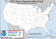
 Well, today's the day! Looks like we are facing the first severe weather outbreak of the season! The spotter chatter is going crazy with a moderate risk for severe weather covers an expanding region where Oklahoma, Arkansas, Texas (Arklatex), and Louisiana come together.
 ...A SIGNIFICANT SEVERE WEATHER OUTBREAK -- INCLUDING SUPERCELLS WITH STRONG TORNADOES -- IS EXPECTED THIS AFTERNOON INTO TONIGHT FOR ERN OK/NE TX...INTO WRN/CENTRAL AR AND NW LA...
This is an amazing set-up for mid-February (as a general rule, last year being an exception) and chasers are chomping at the bit to see some action with this early season event.
The only possibility lies in the current low level clouds in that area inhibiting heating and, therefore, instability, but they are airing on the side of caution at the Storm Prediction Center, understandably. This is not a drill. Folks in the Arklatex and surrounding region should remain vigilantly mindful of what's going on around them this afternoon and into the night. Weather radios should remain on! This could be a horribly nasty afternoon and night!  THE COMBINATION OF INSTABILITY AND VERTICAL SHEAR WILL FAVOR DISCRETE SUPERCELLS WITH THE INITIAL DEVELOPMENT...WHILE THE STRONG LOW-LEVEL SHEAR AND MOIST LOW LEVELS WILL SUPPORT THE POSSIBILITY OF A FEW LONG-TRACK SUPERCELLS WITH STRONG TORNADOES LATE THIS AFTERNOON INTO EARLY TONIGHT ACROSS THE MDT RISK AREA.
get this...
OBSERVATIONAL TRENDS COULD STILL NECESSITATE A HIGH RISK UPGRADE FOR A PORTION OF THE NE TX/SE OK/WRN AR AREA IN THE 1630Z OR 20Z OUTLOOK UPDATESTHIS IS POTENTIALLY A VERY DANGEROUS SITUATION.
God, bless them. Oh, how I hate nighttime tornadic events!! The Storm Prediction Center has issued a Public Severe Weather Outlook (as is the norm when a moderate risk for severe weather exists). As the night rolls on, the possibility of strong,long-tracked tornadoes from the potential dry line supercell outbreak will transform into a squall line thunderstorm event with a few embedded tornadoes possible from the remaining instability; however, at that point, its the damaging outflow winds will pose the greatest threat, which will likely cause more widespread damage. Unfortunately, as the energy shifts eastward and the heating occurs through early hours tomorrow, the squall line danger translates to a slight risk for severe weather through a large part of the east and southeast including much of the area east of the Mississippi valley and well into the Appalachian Mountains, including a significant part of Georgia, including the Atlanta area... not me. Due to some model inconsistencies and some uncertainty regarding the instability magnitude, they are sort of understating the categorical risk... from what could "ACCOMPANY A SYSTEM OF THIS STRENGTH", but based on the wording, I feel like it won't take much to change their minds. It appears that the greatest chance at tornadogeneis, if any, would exist later in the afternoon... AN ISOLATED SUPERCELL MAY BE POSSIBLE... PARTICULARLY FROM THE ALABAMA/FLORIDA PANHANDLE COASTS INTO THE SOUTHERN APPALACHIANS.
... from about Mobile to north Georgia. Again, weather radios, folks.
As you see from this shot of this morning's sky, not much going on here... They are some nice billowing altocumulus clouds though.
Have a great (and SAFE) day! (WEATHER RADIOS ON!!!)
~Dewdrop
Tuesday, February 10, 2009
Moderate risk for Severe Weather in Arklatex
Subscribe to:
Post Comments (Atom)


Ready to arm-chase today’s event.
ReplyDeleteIf only we were there... SDS be darned.
ReplyDeleteARKLAtex? ArklaTEX?? Is that a real term or did you just make it up?! Will I offend someone if I say that it's hilarious? It can still be useful, just hilariously useful. It sounds like a new kind of wall paint or fabric. Well, whatever, stay safe down there. No storms for a while yet up here in the Greater Michonte (Michigan, Ontario, Erie). Seriously, I enjoyed this post, I'm just goofin' around.
ReplyDeleteI did not make it up. It is what that region is referred to as... I happen to love it! It is very much hilarious!
ReplyDelete