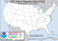
 [Image credit: AP photo of damage in Lone Grove, OK] I was blown away yesterday by the impressive radar presence that the supercells in Oklahoma had. They had classic hook appearance in most cases, and were producing significant wall clouds, hail and tornadoes. What really blew me away was that this line was training over the same area over and over. As one supercell moved on to the next area, another took it's place. Tornado sirens blaring time and time again as deadly and destructive tornadoes dropped in a game of Russian roullette with the ground below. Each of those supercells could have dropped something. It really is amazing that there were not more reports. It was amazing to watch the tornado in Edmond, Oklahoma (near Oklahoma City), to hear about cells near Yukon, Lake Aluma, Union City, Moore, Meridian, Guthrie, Langston, Perkins and Stillwater and cells developed out of nowhere in those same spot.
 OHP Trooper Bryant Harris, who lives in Lone Grove, “There’s nothing left ... twisted metal, cars turned upside down, cars in trees.” ~source
Sadly, with 8 confirmed deaths and more possible. It was a horrific storm that raged through last night. Thoughts and prayers to those folks.
Thanks to Mikey, who sent me a link to a video by TornadoVideo.net of Stream 1 intercepted several supercells including one tornado warned storm near Yukon, ok. This storm had an incredible wall cloud, and showed rapid rotation. Also shown is the hail covered countryside near Guthrie, OK, created from several training supercells throughout the afternoon.
It's a cool video.
Currently, I am supporting Alabama Mike is under a tornado watch and is chasing a severe warned cell that is approaching him.
 This is the base of the remnants from yesterday's storm event. It does have a slight risk for severe weather associated with it, and at the moment, it appears to be bowing slightly where he currently is (the red square):
  ... and he is reporting strong wind gusting around 30 or perhaps over 40 pushing 50mph from the south southwest. The current captures are starting to show some hooky like feature in the radar.
11:56AM:
 His line looks to have lined out just before reaching him, which explains the wind. The upper segments of the line, have some embedded tornado warned supercells.
  One of those tornado warned cells looks trained on Tennessee Mike.
  Super fast moving stuff, too. Storm movement at 71knots!!! Holy guacamole!
12:26PM Mike is racing (within the posted AND BLOWN OVER) speed limit sign. Seriously, the 70mph speed limit sign has been blown over in the what he estimates at 70mph oops 50mph gusts! I think a special exception should be made to allow you to race to outrun a storm that's going faster than you, but as I found out in Nebraska, no such exceptions are made. Be safe, Mike!
12:33PM Mike is setting up to watch this cell roll in... He is in a gorgeous spot overlooking Huntville from a mountain top...
 This is what he's looking at...12:43PM
 He sees a wall of rain in the distance.
Now 12:48PM, another tornado warning headed Tennessee Mike's way. 1:00PM: He is looking at what appears to be a low shelf cloud.
 With crazy wind!
1:05PM: He sees mammatus like clouds under the approaching cell coming in out of his southwest. Have a great day!
~Dewdrop
Wednesday, February 11, 2009
Springlike winter storm...
Subscribe to:
Post Comments (Atom)


Awesome support! I am very grateful for your help, as always!
ReplyDelete