 [I took the picture this past Friday. It gave me hope. Thought I'd share.] With record lows breaking out all over the eastern US as the ridiculous monster storm continues to leave monstrous cold air in its wake, and record high temps in Texas, actually breaking records set before Texas was even Texas (INSANE!), it's hard not to think... what next?! Well, it looks like we have a lull in the action for now, with a warming trend sweeping into my area (hooray! at last!) Unfortunately, before things can approach warmer temperatures, we had to suffer through another freezing morning, with this ridge hunkered down and making its presence known. I read the area forecast discussion (AFD) for the first time in a while... I know I've said it before, but I always love reading Kelly's (meteorologist at Tally office) AFDs, even with the way they have toned down the wording since before, which is actually why I don't read them as much as I used to. They used to entertain me a great deal... now, I just get to enjoy Kelly's closing "HAVE A GREAT DAY!"
  With a lull in significant weather, I tend to look back over recent events. I was impressed to see that Tallahassee's Weather Service Office has posted a summary listing of the recent (and some less recent) significant weather events in the Tallahassee county warn area (CWA). It's a nice summary compilation of the 21 significant severe events over the past 10 years that have impacted my area. Looks like Saturday made the cut with golf ball sized hail and significant straight line wind damage. No mention of the newspaper reported "tornado" in Valdosta... which I am convinced was actually a rain foot. It also includes the February 18-19 system, which included a very long-tracked tornadic supercell that raced across the entire CWA in the wee hours of the night and produced baseball sized hail!
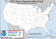
 The above is a radar capture from the long-tracked tornado in Thomas County that night, with the general proximity of my location at the time indicated with the star. Again... way too close!
Speaking of hail, I heard that the parameters for severe hail size has been increased once again. As of my most recent training, a severe thunderstorm would be indicated by possibly hail the size of a penny or larger; however, according to TWC, the parameter calls for quarter sized hail or larger for a thunderstorm to be considered severe by the hail size alone. Here is the previous chart:Estimating Hail Size:
Have a GREAT DAY!
Pea = 1/4 inch diameter
Marble/mothball = 1/2 inch diameter
Dime/Penny = 3/4 inch diameter - hail penny size or larger is considered severe
Nickel = 7/8 inch
Quarter = 1 inch
Ping-Pong Ball = 1 1/2 inch
Golf Ball = 1 3/4 inches
Tennis Ball = 2 1/2 inches
Baseball = 2 3/4 inches
Tea cup = 3 inches
Grapefruit = 4 inches
Softball = 4 1/2 inches
~source
~Dewdrop
Wednesday, March 04, 2009
Record high temps, record low temps... what?!
Subscribe to:
Post Comments (Atom)


Interesting comments concerning hail size, Dew. I've listened in on quite a few Skywarn nets here in the Dallas/Ft. Worth area and the minimum hail size has always been quarter-sized hail or larger. I guess it could be different in other areas of the country where hail storms are less prevalent. Still interesting, regardless.
ReplyDeletePerhaps, that's it Ken. Maybe there is a different parameter for different areas, so they were only elevated one area. They made the report sound more broad than that, but you know TWC. They actually like for us to call in any hail here. It's not too common (to the point that I have NEVER seen it).
ReplyDeleteFrom Wikipedia... "In most of the United States, a storm is considered severe if winds reach over 50 knots (58 mph or 93 km/h), hail is ¾ inch (2 cm) diameter or larger, or if funnel clouds and/or tornadoes are reported. In the Central Region of the United States National Weather Service, the hail threshold for a severe thunderstorm is not until it is 1 inch (2.5 cm) in diameter." ~source
ReplyDeleteYep. I figured it had to be bigger here in the Plains due to the frequency of hail storms. The biggest hail that I can recall seeing personally was roughly tennis ball to baseball-sized.
ReplyDeleteAlso, please keep me in your thoughts, as my wife and I are planning on making some serious sacrifices in order for me to finally pursue my dream of becoming a meteorologist. That is the direction that I truly feel God wants me to go.
I'm jealous, Ken! Way to chase your dreams. I will keep you in my prayers as you pursue your dream. How awesome!
ReplyDeleteWe have had the freakiest weather for our parts this week. One day of snow then hours of rain, still the next and now it's bitter winter again. Nothing like your weather though when I read this.
ReplyDeleteThat is really spectacular.
ReplyDelete