 SKY WATCH FRIDAY time! Please visit Klaus, Sandy, Ivar, Wren, Louise and Fishing Guy, the team for SKY WATCH FRIDAY (click the word to link and participate!) Thanks to Dot and Tom, who were instrumental in the success of this blogging event. You should definitely come fly with us!
 This is a capture of a swelling cumulus cloud... I watched as the cloud swelled and grew before my eyes, climbing vertically in a hostile atmosphere, ready to explode with thunderstorm. Here is a link to a time lapse video of a thunderstorm developing, and it shows the stages of development of a thunderstorm... from fair weather cumulus to swelling cumulus to towering cumulus/cumulus congestus, where the thunderstorm has formed. Seeing lots of these cumulus towers would indicate a great deal of instability, moisture and lift, and you can expect some thunderstorms.
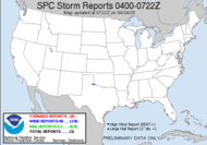
Today you can expect thunderstorms if you are in the southeastern US, severe thunderstorms at that... With up to 17 tornadoes now reported from Monday's severe weather outbreak, 1 reported on Tuesday, and 6 reported yesterday 
Frankly round one has actually expanded the severe zone to nearly include me (should include me overnight... sigh), and as the squall line approaches, if it maintains any structure, it will impact my area and most of Georgia.  In fact, the line is just about to cross into Georgia further north of me. A tornado watch is in place through the area of the present squall and just to its east, and although the line seems to have weakened as it has entered Dewvoid territory, the tornado watch will persist for the 40% moderate chance that the area will see tornadoes. Like I said though, this is only round 1 for the south.
 Round 2 (above) actually includes my neck of the woods as severe weather persists in the southeastern US.
THE IMPLICATIONS OF THIS IMPULSE POTENTIALLY INCLUDE: 1) CONSIDERABLE TSTM DEVELOPMENT OCCURRING EARLY IN THE DAY OVER THE CNTRL/ERN GULF STATES WHICH WILL HAVE IMPACTS ON THE EVOLUTION OF THE SYSTEM WARM SECTOR...AND 2) THE LOW-LEVEL MASS RESPONSE TO THIS LEAD IMPULSE. IN OTHER WORDS...LATEST MODEL FORECASTS ALL VEER AND MIGRATE THE LLJ EWD FROM THE CNTRL/ERN GULF STATES TOWARD THE SERN ATLANTIC COAST. WHILE AIR MASS WILL NOT BE PARTICULARLY UNSTABLE...WIND FIELDS WILL BE RELATIVELY STRONG AND SUPPORTIVE OF ORGANIZED/ROTATING STORMS CAPABLE OF DAMAGING WINDS AND PERHAPS TORNADOES. THERE IS UNCERTAINTY AS TO WHAT IMPACTS THIS INITIAL STORM ACTIVITY WILL HAVE ON THE DEVELOPMENT OF THE WARM SECTOR.
LLJ IS EXPECTED TO RAPIDLY STRENGTHEN FRI NIGHT FROM NEAR THE MS RIVER EWD THROUGH THE CNTRL GULF STATES AND NWD THROUGH THE TN VALLEY. AS SUCH...KINEMATIC ENVIRONMENT WILL BECOME INCREASINGLY FAVORABLE FOR TORNADIC SUPERCELLS... THE CORRIDOR ALONG AND JUST TO THE S/SE OF THE SURFACE LOW TRACK WILL REMAIN QUITE FAVORABLE FOR LONGER-LIVED SUPERCELLS CAPABLE OF TORNADOES /SOME POSSIBLY STRONG/. THREAT FOR DAMAGING WINDS...HAIL AND ISOLATED TORNADOES SPREADING EWD INTO MIDDLE TN AND AL BY 28/12Z.
DUE TO THE CONCERNS AND UNCERTAINTIES LISTED IN THIS DISCUSSION...A CATEGORICAL SLIGHT RISK WILL BE MAINTAINED. BUT...AN UPGRADE IS STILL POSSIBLE IN LATER OUTLOOKS ONCE FINER-SCALE DETAILS BECOME MORE CLEAR. Then, it almost immediately feeds into round 3. (above)
...WIDESPREAD SEVERE WEATHER POSSIBLE SATURDAY INTO SATURDAY NIGHT...
Should be a wild next few days.
MOISTURE WILL COMBINE WITH THE SIGNIFICANT HEIGHT FALLS/DYNAMIC COOLING MENTIONED ABOVE TO SUPPORT AIR MASS DESTABILIZATION OVER A LARGE REGION E OF THE MS RIVER SATURDAY INTO SATURDAY NIGHT. THE COMBINATION OF THE VERY STRONG WIND FIELDS AND DYNAMIC FORCING FOR ASCENT WILL FAVOR MULTIPLE LINE SEGMENTS WITH EMBEDDED SUPERCELLS/BOWS CAPABLE OF POTENTIALLY WIDESPREAD DAMAGING WINDS...HAIL AND TORNADOES. THE SEVERE WEATHER THREAT WILL CONTINUE SATURDAY NIGHT OVER PORTIONS OF GA/N FL INTO THE CAROLINAS AND VA ALONG/AHEAD OF COLD FRONT SURGING THROUGH THE APPALACHIANS. WIND FIELDS WILL REMAIN VERY STRONG WITH A CONTINUED THREAT FOR SUPERCELLS/BOWS CAPABLE OF TORNADOES AND DAMAGING WINDS.
AN UPGRADE TO MODERATE RISK MAY WELL BE REQUIRED IN LATER OUTLOOKS ONCE FORECAST DETAILS BECOME CLEARER. (This is Saturday, they are talking about upping to a moderate risk for severe, and guess who is planning to go storm chasing??? ) 9:43EDT: Looks like Enterprise, AL is under fire with a tornado warning in that area. They suffered a blow two years ago on March 1, 2007, when an EF4 caused extensive damage and stole some lives.
  Incidentally, the slight risk today has expanded since my earlier post... I am officially within an area of slight risk for severe weather. Much of Georgia has been included in the area.
Thanks to the Weather Channel for sending me a link to the preliminary report from Jackson, MS, regarding the "AT LEAST AN EF3" tornado that ripped through Magee, MS very early this morning, leaving many injured, some seriously, some people missing, documents moved to other counties and dozens of structures damaged or destroyed.
Update on Enterprise, one of three wind reports today:ENTERPRISE COFFEE COUNTY AL
Stay tuned.
SEVERAL REPORTS OF DAMAGE AROUND ENTERPRISE. SEVERAL TELEPHONE POLES DOWN...TWO CHICKEN HOUSES SIGNIFICANTLY DAMAGED. ONE TRAILER WITH ROOF DAMAGE.
~Dewdrop
Thursday, March 26, 2009
Southeast facing a 1, 2, 3 punch of severe weather
Labels:
severe weather in south Georgia
Subscribe to:
Post Comments (Atom)


Great photo of the cloud!Your post is very interesting again.Thank you for sharing!
ReplyDeleteHave a nice weekend and Happy SWF!
You've made me much more aware of building clouds, Dewdrop. It is fun to watch cumulous clouds grow, I agree. I don't mind thunderstorms...in fact, I rather LIKE them. But tornadoes are scary. I hope all is well in your neck of the woods!
ReplyDeleteYou were on target with the squall line coming through this morning. We just received some heavy rain (some sideways)...no thunder or anything significant. I've seen some say that the really severe stuff will be crossing over into GA somewhere around 6-7am on Saturday. That's what I'm trying to determine now, will it start as a night event and start to really fire in the mid-morning (7-9am), or will it get started in GA in the mid-morning on Saturday and continue through the afternoon. Every new bit of information keeps pushing it back later and later.
ReplyDeleteYou were on target with the squall line coming through this morning. We just received some heavy rain (some sideways)...no thunder or anything significant. I've seen some say that the really severe stuff will be crossing over into GA somewhere around 6-7am on Saturday. That's what I'm trying to determine now, will it start as a night event and start to really fire in the mid-morning (7-9am), or will it get started in GA in the mid-morning on Saturday and continue through the afternoon. Every new bit of information keeps pushing it back later and later.
ReplyDeleteOh my goodness all I could muster was number four this week.
ReplyDeleteI love cumulus clouds; I think they are my favorites.
love the shot
ReplyDeleteMy entry for SWF post this week: in HERE. I hope that you can stop by as well. Thanks
i love to watch clouds like that. I've seen them from airplanes, but as beautiful as that is, I prefer to be on the ground when they are swelling so fast. Beautiful shots!
ReplyDeletethat is a stunning photo. I see you are sending that wet weather up to us in Southern Ontario for Saturday.....
ReplyDeleteGill in Canada
i so enjoy reading your blog...good reading and so informative. thanks as always for keeping us posted.
ReplyDeleteThose are beautiful cumulus clouds. I love watching them too.
ReplyDeleteBeautiful FAT clouds. I love it.
ReplyDeletegood to see here that i've seen massive clouds as signs of warmer weather...
ReplyDeleteCheck out mine too:
HISTORY of SUPERNOVA and SWEETPAIN
ANGELS IN MY LIFE
SPICES OF LIFE
It's day two here of fairly gentle spring rains so far.
ReplyDeleteLove the pic - the calm before the storm! :)
Hey you... SPC just put out a MOD risk for tomorrow in the Lower MS Valley.
ReplyDeleteAnd it looks like the TLH bubble is well and working... So I'm pretty sure the Dew-Void will be in full effect later this afternoon.
Looks like a big ole cloud boiling up over the trees! Very dramatic capture and nice, of course!
ReplyDeleteThat's a beautiful cloud and as always an informative post. Tornadoes aren't that common in NC where I live but we've had several that were a wake up call that they can happen here.
ReplyDeleteWow dew, that first photo is outstanding, love those clouds.
ReplyDeleteHave a great weekend!
Guy
Regina In Pictures
Wonderful cloud picture you have for us. That informative write up must have taken some time to prepare too. Thank you.
ReplyDeleteWe have gusty weather and rain here.
Well March in like a lion out like a lamb. I hope so anyway.
Nice cloud, you do seem to be having a lot of wild weather.
ReplyDeleteAmazing to watch them swell isn't it?
ReplyDeleteInteresting time lapse of the thundercloud formation. I'm glad I'm not in the southeast today. Here in Utah we have high winds and a chance of snow.
ReplyDeleteThis reminds me of a cloud of sulfur too..as in volcanic- very dramatic! Happy tracking! Thanks for the info-
ReplyDeleteGreat skywatch post. I enjoyed the time-lapse thunderstorm.:)
ReplyDeleteI love watching those big clouds grow and change - especially nice on your back with binoculars!
ReplyDeleteThat is a great photo and the information is very interesting. Thank you for sharing.
ReplyDeleteSmiles
As always, a very interesting post. Love that fluffy cloud.
ReplyDeleteBeautiful shot and amazing video of cloud formation before a thunderstorm.
ReplyDeleteand after all that I still don't know if I'm gonna have sufficient lightning activity on Saturday night to get the lightning shots I've been planning to try. I think I have the "how" worked out, the "where" is still sketchy, but the biggest question is "when"? Because I can control the first two, but the last one ain't up to me.
ReplyDeleteThat's a great cumulus!
ReplyDeleteIt's always great to see such a cloud develop. Thanks for sharing this shot and the interesting link.
Have a good weekend.
great pic happy swf
ReplyDeleteYou have taught me so much I actually recognised the first image. I mean instead of beautiful cottonball fluffy white mass I'm like ooh a gorgeous cumulus.
ReplyDeleteEach cloud you photograph is like a universe.
ReplyDeleteHey are you hoggin' all the rain? ;) We didn't get any here in SW Florida. I do love it when you can watch a cloud "bloom" before your very eyes - fun stuff!
ReplyDeleteTGIF!
Tink *~*~*
Fort Myers Beach Moon
Hey dewdrop, you had the first comment on Skywatch Friday. Love your site. Glad to find it! Happy Skywatch Friday.
ReplyDeleteGreetings from Finland, never tornadous or any bad storms like you have there, but frosts and snow enough, which are not dangerous at all even they stay five months :)
ReplyDeleteYour nickname made me curious, because I love those dewdrops.
My favorite photo is this:
http://leejattas.aminus3.com/portfolio/105.html
Your post brought to my mind my studying days, when I had to learn
all kind of clouds and weather conditions. The book was written in German and in it was over thousand pages, I had my first baby
helping me to read :))We managed very well.
Thank you for fine post!
Beautiful big cloud!
ReplyDeleteAwesome formation and you have captured it beautifully.
ReplyDeleteMy Skywatch:
Full Moon Sunset
Hi Dew, wonderful swelling cloud capture. Well you'd enjoy our weather system here today, I am curretnly sitting in a blizzard!
ReplyDeleteWhat a beautiful cloud! It must have been exciting to watch it form.
ReplyDeleteThat is a wild swelling cumulus cloud! So amazing that you got to watch it, makes for a fantastic photo!
ReplyDeleteDew: Really neat capture of the building cloud. Your area certainly got some needed rain this week.
ReplyDelete