 This thick sheet of fog, which was actually worse, as I approached the city, earned us a dense fog advisory.
 MOIST ONSHORE FLOW FROM THE GULF OF MEXICO IS COMBINING WITH RADIATIONAL COOLING TO PRODUCE AN EXPANDING AREA OF DENSE FOG ACROSS THE REGION THIS MORNING. VISIBILITIES ACROSS MANY LOCATIONS IN THE TRI-STATE AREA HAVE ALREADY DROPPED TO 1/4 MILE OR LESS...AND THIS AREA OF DENSE FOG IS EXPECTED TO BLANKET MOST OF THE REGION BEFORE SUNRISE. THIS FOG IS EXPECTED TO LINGER FOR A COUPLE OF HOURS AFTER SUNRISE BEFORE IT LIFTS AND BURNS OFF.
More fog and warm, sunny weather lies in store for us!
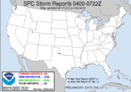
A DENSE FOG ADVISORY MEANS VISIBILITIES WILL FREQUENTLY BE REDUCED TO LESS THAN ONE QUARTER MILE. IF DRIVING... SLOW DOWN... USE LOW BEAM HEADLIGHTS... AND LEAVE PLENTY OF TIME TO REACH YOUR DESTINATION. In the meantime, the plains states are experiencing a fit of a spring storm, with tornadoes on one side and a blizzard on the other. The slight risk for severe weather today mimics yesterday's graphic, except a little further to the east... and those on the northwest side of that line need to break out their parkas. In fact, as the systems moves eastward, we can expect to see drops in temperatures as far south as Atlanta (whew!) with departures from the norm hitting fast and these warm sunshiny days disappearing... As Ken and I discussed yesterday, there was no tornado action yesterday, but Oklahoma and Kansas saw hail up to 2.19" (what?!) and wind gusts up to 60mph.
THE GREATEST JUXTAPOSITION OF FAVORABLE INSTABILITY AND SHEAR FOR SUSTAINED STORMS/SUPERCELLS LATE THIS AFTN SHOULD EXIST FROM NW AR/SW MO NE INTO CNTRL IL. STORMS IN THIS CORRIDOR COULD YIELD A COUPLE TORNADOES IN ADDITION TO LARGE HAIL/LOCALLY DMGG WIND.
I can't remember seeing such powerful wording in a slight risk environment with only a 5% probability of tornadogenesis. Weird.
Have a great day!
~Dewdrop
Tuesday, March 10, 2009
Warm, foggy days in the south... tornadic days in the midwest... blizzard in the north...
Subscribe to:
Post Comments (Atom)


Your post today (boring clear sky day) reminded me of the Aruba commercials (#1&2) I've been seeing on TV. LOL! :o)
ReplyDeletehttp://www.youtube.com/watch?v=sFkvfK8srBk
LOL! I don't remember ever seeing that commercial. This weather is heck on storm chasers.
ReplyDelete