 SKY WATCH FRIDAY time! Please visit Klaus, Sandy, Ivar, Wren, Louise and Fishing Guy, the team for SKY WATCH FRIDAY (click the word to link and participate!) Thanks to Dot and Tom, who were instrumental in the success of this blogging event. You should definitely come fly with us!
 OK, I knew that tomorrow's set-up looked ripe. I knew that they have been expecting the most severe storm of the year, in fact trying to compare the storm to horrific outbreaks of the past, but I did not expect that I would wake up to see myself in the area of moderate risk for severe weather. Worse, it looks like a night event.
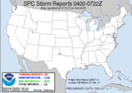
 The first is a snapshot of the current radar activity with the mapped out areas of severe probabilities. The second shows the likelihood of tornadic activity. An unfortunate issue is that the portion impacting my neck of the woods is expected to arrive in the middle of the night. The Storm Prediction Center (SPC)has issued a Public Severe Weather Outlook for us. Yikes.
THE NWS STORM PREDICTION CENTER IN NORMAN OK IS FORECASTING THE DEVELOPMENT OF TORNADOES...LARGE HAIL AND DAMAGING WINDS FROM THE LOWER MISSISSIPPI RIVER VALLEY AND MID-SOUTH REGION INTO THE SOUTHEASTERN U.S. TODAY AND TONIGHT.
It looks like rough day and night lies ahead...
THE AREAS MOST LIKELY TO EXPERIENCE THIS ACTIVITY INCLUDE
ALABAMA
NORTHERN FLORIDA
WESTERN AND SOUTHERN GEORGIA
MISSISSIPPI
WESTERN TENNESSEE
INTENSE SPRING STORM SYSTEM TAKING SHAPE OVER THE SOUTHERN PLAINS EARLY THIS MORNING WILL BRING A RISK OF WIDESPREAD SEVERE THUNDERSTORMS BEGINNING EARLY TODAY AND CONTINUING INTO THE OVERNIGHT PERIOD ACROSS MUCH OF THE DEEP SOUTH. ADDITIONAL AREA OF SEVERE THUNDERSTORMS MAY EVOLVE OUT OF THE NORTHEASTERN GULF COAST INTO ADJACENT AREAS OF NORTHERN FLORIDA...FAR SOUTHERN ALABAMA AND SOUTHERN GEORGIA TODAY.
DEEP LAYER SHEAR WILL BECOME VERY STRONG AS ENHANCED WIND FIELDS ALOFT OVERSPREAD THE ENTIRE REGION TODAY. THIS WILL OCCUR AS GULF MOISTURE STREAMS NORTHWARD AND FUELS A LARGE AREA OF UNSTABLE AIR WITH AFTERNOON HEATING. SEVERE THUNDERSTORMS ACROSS THE AREA WILL EVOLVE AS SUPERCELLS AND SMALL LINES OF STORMS. TORNADOES...A FEW OF WHICH COULD BE QUITE STRONG AND/OR LONGER-LIVED...ARE EXPECTED THROUGH TONIGHT OVER THE REGION. LARGE HAIL AND DAMAGING WIND GUSTS WILL BE ADDITIONAL HAZARDS FROM THESE STORMS.THEN TORNADOES CAN BE EXPECTED...SOME POTENTIALLY STRONG AND LONG TRACK. BETWEEN 18-00Z IT APPEARS THE GREATEST THREAT FOR TORNADIC SUPERCELLS WILL BE ACROSS NRN LA/SERN AR/MS INTO WRN AL/TN.
Oh dear...
FARTHER SOUTHEAST (where I am)... SHEAR PROFILES WILL BECOME QUITE STRONG ATOP AN INCREASINGLY UNSTABLE AIRMASS. IN FACT EMBEDDED IMPULSES WITHIN THIS FLOW MAY ACTIVATE ROBUST THUNDERSTORM DEVELOPMENT EARLY IN THE PERIOD. FORECAST SOUNDINGS ACROSS THIS REGION ARE IMPRESSIVE WITH SHEAR/INSTABILITY STRONGLY INDICATIVE OF SUPERCELLS CAPABLE OF GENERATING TORNADOES...SOME OF WHICH MAY BE STRONG. (clickable image) A tornado watch has just been issued for my area for this first impulse, but the main event should arrive later. I have a bad feeling.
9:30: Impressive cell headed my way... has rotated at points. Thursday, of course. The storm fell apart, and is just one huge blanket of rain with thunder and lightning sporadically thrown in for good measure... with such rains, especially to our north, we are experiencing flooding locally. Already some rescues have had to take place where the river is absolutely out of control. With all this rain, it continues to rise. This is the house across from my wonderful gtb's parents yesterday. I just spoke with his mother, and she said the water is much higher today.


I just worry at this point at people's perspectives. They are hearing severe weather warnings and this first impulse might make them think that the threat is over, but the threat arrives tonight, too! Don't let your guard down people. The tornado watch has expanded...
5:40PM, rotation headed this way:
 6:30PM Running out of time before this rotating mess is upon me...
 ~Dewdrop
Thursday, April 02, 2009
Moderate risk, right here...
Subscribe to:
Post Comments (Atom)


This system does seem to have more potential than the last. I certainly hope that potential isn't realized, but it is looking more likely as each hour passes that this one will break out. Every report I see has Carroll County (my county) barely within the moderate risk/likely severe zone or right on the edge. How do you expect these storms to unfold? Supercells, squall line, all of the above? It seems like SPC, NWS, TWC, etc. expect this system to die out in the northern third of GA but really dig down your way and maintain some strength overnight.
ReplyDeleteTake good care. That looks like a very angry sky to me.
ReplyDeleteAll the best, Dewdrop! I hope all is well.
ReplyDeleteYou are always a wealth of information and that sky photo looks scary!!
ReplyDeleteGill in Canada
What a spectacular storm cloud photo....great contrast. Quite an informative weather report, too.
ReplyDeleteDid I read in your SW comment that you're getting married on Saturday!? Congrats! Have a wonderful celebration!
That is one ragged cloud you've caught. Hope it was all show and no blow!
ReplyDeleteAwesome skywatch post as always, the first shots looks ominous, I love it.
ReplyDeleteHave a great weekend!
Guy
Regina In Pictures
Your photo is great for a SWF!Your informations are really good every week!Thank you for sharing!Have a nice weekend!
ReplyDeleteOur weather is so moderate that it's hard for me to even remember living under the threat of storm. I grew up with them, and no time of year was ever without severe weather from time-to-time. So I hope you get some sleep! (And love the stormy clouds photo.)
ReplyDeleteGorgeous photo of those clouds! I hope you stay safe.
ReplyDeleteOminous but beautiful sky. I want to join in with the other stay safe comments.
ReplyDeleteI think it was last week that your post was the first I heard of the chance of tornadoes where I live in NC. Over the weekend we had tornado warnings and one touched down about 20 miles from me (if I have that right) but fortunately no one was hurt.
hope things don't escalate...take care.
ReplyDeletealways enjoy your photos and commentary...excellent.
Just scary.
ReplyDeleteAs impressive as it is I should hope it has passed on Saturday. I read that you have a very special occaision coming up. Congratulations are in order. Hope you'll have a wonderful day.
ReplyDeleteBlessings.
Thank you for your explanation on last week's pst :) Now, this one really looks like its gonna fall down...my, scary yet fascinating...
ReplyDeleteAnyway I hope that it didnt get worse...
I love your great threatening black cloud. I guess I just keep praying for precipitation.
ReplyDeleteThis comment has been removed by the author.
ReplyDeleteWow those are some pretty awesome clouds, looks like time to head for cover.
ReplyDeleteThat looks like a storm that is coming and won't look back.
ReplyDeleteThe image of the threatening sky is breathtaking. I hope it is not cause any more havoc in your part of the world. I sit here and feel humbled, what with complaining about a series of grey skies and rain, nothing dangerous, just annoying missing the blue sky for so long. Right now, though, it's blue skies and springlike temperatures.
ReplyDeleteWow! What a lot of drama! Stay safe! This is extreme Skywatching!
ReplyDeleteI adore veiwing these ominous dramatic skies, but I also appreciate it is not a pretty site if you are there. Take care and well done you for alerting so many people to the dangers aswell as the beauty of the elements.
ReplyDeleteSomething dark is your way headed. Looks bad. Be safe and thanks for the picture and write up.
ReplyDeleteGoodness - what an ominous sky! I'm glad the tornado didn't materialize. Too bad about the flooding, though.
ReplyDeleteDew: It seems some places that had drought conditions are now making up for the shortfalls. What a lot of rain.
ReplyDeleteWwo, you are a pro and impressive shot. The night-look sky gave you a wonderful photo.
ReplyDeleteVery dramatic grey sky there.
ReplyDeleteSydney City and Suburbs
The clouds are beautiful!
ReplyDeleteWith such weder can you make beautiful pictures!
Greay shot!
Gr.
P-TER
I love this shot! Not often when you can get clouds this dramatic.
ReplyDeleteThey even mentioned on the OK news about the possibility for large tornadoes in the TN area, so I was wondering whether they materialised. Good to know it disapated, although that's alot of water!
ReplyDeleteI think I'll take my snow over that weather! Stay safe and I hope the water doesn't reach your home.
ReplyDeleteAs always I enjoy all the info you share. Your sky photo is wonderful, the way the clouds mirror the trees is stunning.
ReplyDeleteVery impressive photo of the dark and menacing clouds for your SkyWatch post!
ReplyDeleteMy first spring aka tornado season since my move here to Kansas is upon us... since we live in a rural area with wide open vistas, esp to the southwest, I am hoping I can catch some fantastic storm photos soon!