 More unfortunate news from Haiti this morning, their strongest aftershock yet, struck at 6:03AM, with a 6.1 magnitude, just 35 miles from Port-au-Prince, not far from the original major earthquake 8 days ago. I haven't heard reports about how the already dangerous state of Port-au-Prince's structures were impacted or if any rescue workers were impacted, which is my first thought, but it is clear that they continue to need all of our prayers.
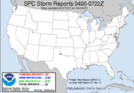
Back here, we have a relentless weather pattern, which is inundating much of the country with one type of weather or another. A series of low pressure systems is parading its way across the country moving in off the Pacific.  Strong low pressure systems are dumping record rainfall on California, causing incredibly dangerous landslides and threats of more, as more rain moves in. As if that's not bad enough, southern California actually reported 3 tornadoes, including one in Los Angeles. Apparently, the turmoil in the water (20' waves) caused some water spouts which moved inland.
GOLETA SANTA BARBARA COUNTY CANeither San Diego, not Los Angeles's Weather Service Office reference the tornado at this time.
RADIO STATION KCOY IN SANTA BARBARA REPORTED A SHERIFFS DEPUTY SPOTTED A POSSIBLE TORNADO NEAR THE OCEAN MEADOW GOLF COURSE NEAR ISLE VISTA AROUND 1030 AM...ROOF DAMAGE (LOX)
HUNTINGTON BEACH ORANGE COUNTY, CA
TORNADO SPOTTED ON PACIFIC COAST HIGHWAY JUST SOUTH OF ANDERSON STREET. THE FUNNEL CROSSED THE HIGHWAY AND HEADED NE. A BLACK LIMO WAS LIFTED UP AND AN SUV WAS FLIPPED (SGX)
HUNTINGTON BEACH ORANGE COUNTY CA
PROBABLE (Interesting wording) TORNADO IN HUNTINGTON BEACH. BOATS UPLIFTED AND DAMAGED IN THE HB HARBOR. DAMAGE TO BUILDING IN AREAS. CAR FLIPPED 16400 PCH. (SGX)
Local Storm Reports
Los Angeles
San Diego
Unfortunately, that same system is now causing treacherous blizzard conditions in the mid-west, with ice storms and just a huge mess. For us, down in the south, this all spells out severe weather potential.
For today, much of the central Gulf states are under a slight risk for severe weather with a mentionable tornadic threat. The area of risk stops short of my area with a new threat bumping into tomorrow's forecast.


Anyone within the green outlined area, should be mindful of rapidly changing conditions. The second graphic depicts the probabilities for tornadoes.
I am keeping a closer watch on tomorrow. Before you ask, NO! I WILL NOT BE CHASING! It's payroll day for me, so I will be stuck at my desk, missing out on all the fun, but the wording has me intrigued.
 You see, though it looks like instability will be lacking, south Georgia and north Florida look like the ripest areas for action. As in, if anything is going to happen, it is most likely to occur in my neck of the woods. I'll break down the discussion.
...SERN AL...SRN GA AND NRN FL...So, basically, all the ingredients for potential tornadoes in south Georgia (north Florida) are lining up for tomorrow. If we get a clearing in the sky, watch out! That's the only ingredient that is needed to trigger a significant event.
AN MCS (mesoscale convective system-large rotating storm system) SHOULD BE IN PROGRESS OVER THE SERN STATES EARLY THURSDAY WITHIN ZONE OF ISENTROPIC LIFT (warm air overriding cold air. Lift is a key element of thunderstorms.) WIDESPREAD CLOUDS AND PRECIPITATION SHOULD LIMIT MLCAPE (low instability- due to limited heating potential, cloud cover) TO WELL BELOW 1000 J/KG EAST OF ONGOING STORMS...BUT PARTIAL CLEARING WILL BE POSSIBLE FARTHER DOWNSTREAM ACROSS FL AND SRN GA (we might HERE have just enough break in the clouds to allow for the heating to destabilize things, instability is another key element for thunderstorms). STORMS DEVELOPING NEAR THE SRN END OF THIS MCS WILL EXPERIENCE AN INFLUX OF RICHER LOW-LEVEL MOISTURE (the third and final ingredient of thunderstorms.) AND THEREFORE SHOULD HAVE A BETTER CHANCE OF BECOMING ROOTED NEAR THE SURFACE. STRONG VERTICAL SHEAR (a fourth ingredient making conditions ripe for tornadoes) ACCOMPANYING THE SHORTWAVE TROUGH WILL CONTRIBUTE TO A THREAT OF SUPERCELLS AND BOWING STRUCTURES WITH DAMAGING WIND AND ISOLATED TORNADOES POSSIBLE AS ACTIVITY DEVELOPS EWD. HIGHER PROBABILITIES MAY BE NEEDED IN LATER OUTLOOKS IF IT BECOMES MORE APPARENT THAT THE BOUNDARY LAYER WILL UNDERGO SUFFICIENT DESTABILIZATION.
Be safe,
~Dewdrop


We keep praying and hoping we can send some help.
ReplyDelete