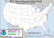
 Well, well, well... with severe weather season finally upon us, and today having the potential to be the most active day of the season... you can bet, I have an eye on things today. Yesterday was an active day, as predicted, with a whopping 32 tornado reports.... and apparently, that was just an appetizer. Now, we're cooking with Crisco! Today's moderate risk for severe weather and public severe weather outlook present an ominous picture of what's to come today.

Anyone in the outlined area should be vigilant and mindful of rapidly changing conditions. Keep your weather radios nearby and be ready to seek shelter in a safe place. It is very likely that there will be tornadoes today.
REGIONAL SEVERE WEATHER OUTBREAK INCLUDING THE POTENTIAL FOR STRONG TORNADOES IS POSSIBLE TODAY. HIGH HELICITY VALUES GIVE CONFIDENCE IN MAINTAINING THE FORECAST OF MULTIPLE TORNADOES /SOME STRONG/ TODAY OVER THE MODERATE RISK AREA. THE AREAS MOST LIKELY TO EXPERIENCE THIS ACTIVITY INCLUDE:For tomorrow, the threat shifts eastward and confidence increases. I would not be surprised to see this moderate threat for tomorrow increased to a High Risk PDS situation, with a high likelihood of a significant tornado outbreak. I've got several friends who will be chasing the event in Alabama, Mississippi and Tennessee... Be safe, Mike, Rick, Jenn (the other storm chasing Jenn, not me) and Jeff (from what I hear)... sorry JB, sounds like Dew timing to me on your brother's wedding. Be safe to all of you chasers out there!!! Live to chase another day.
ARKANSAS
NORTHERN LOUISIANA
NORTHERN AND WESTERN MISSISSIPPI
WESTERN TENNESSEE
NORTHEAST TEXAS


If the system accelerates, I can possibly chase some of the evening if it makes it into SW Georgia, but I have my sights set on chasing Sunday, wherever the weather happens. Stand alone statement in the discussion regarding tomorrow's weather:--TORNADO OUTBREAK POSSIBLE OVER PARTS OF THE LOWER MS AND TN VALLEYS INTO CNTRL GULF STATES SATURDAY INTO SATURDAY NIGHT--
SET THE STAGE FOR A SIGNIFICANT...AND WIDESPREAD OUTBREAK OF SEVERE THUNDERSTORMS THROUGH MUCH OF THE DAY TWO PERIOD. THE GREATEST THREAT FOR CYCLIC SUPERCELLS CAPABLE OF SIGNIFICANT TORNADOES WILL EXIST FROM THE VICINITY OF THE SECONDARY LOW TRACK SEWD INTO THE WARM SECTOR /I.E. LARGELY DELINEATED BY MDT RISK AREA/. ENVIRONMENT WILL BE CHARACTERIZED BY DEEP EFFECTIVE INFLOW LAYERS YIELDING EFFECTIVE SRH IN EXCESS OF 200-300+ M2/S2...MODERATE INSTABILITY AND 50-70 KT OF DEEP-LAYER SHEAR. SEVERE STORMS CAPABLE OF MAINLY DAMAGING WINDS AND TORNADOES WILL CONTINUE THROUGH THE NIGHT WITH THE THREAT EXTENDING NWD THROUGH THE OH RIVER AND AS FAR E AS THE CNTRL/SRN APPALACHIANS AND ERN GULF STATES.
The Final round arrives Sunday, where a slight risk for severe weather exists in my neck of the woods, and the Southern Weather Brigade in south Georgia is gearing up. My plan is to go wherever the weather presents itself. I suspect afternoon, well east of here, closer to the coast, and I plan to chase it over there.


A TORNADO AND DAMAGING WIND THREAT OVER THE SERN STATES SUNDAY MORNING INTO EARLY AFTERNOON MAY TRANSITION TO PRIMARILY DAMAGING WINDS THROUGH THE PEAK OF THE DIURNAL HEATING CYCLE ACROSS THE PIEDMONT AND COASTAL PLAIN.Looks like they are doing a good job of forecasting the Dewvoid, already turning it into a mainly wind event. Sigh... I'm on stand-by. Wish I wasn't busy on Saturday.
~Dewdrop


No comments:
Post a Comment
Dew comment, please...