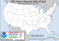
When the moderate risk popped up for eastern Oklahoma, JB contacted Alabama Mike (both members of the Southern Weather Brigade) about the chasetunity it presented and asked if he would like to join him on a trip to Oklahoma today. They watched the models throughout the weekend, and decided ultimately last night that they would pursue a moderate risk or greater, but they would go ahead and leave at the butt-crack of dawn to get on the road and be in position once the intsbility got there, with plans to turn around if it was (doubtfully) downgraded. When I heard from Alabama Mike this morning, they were 112 miles from Oklahoma, had been driving through the rain all morning through Arkansas and were very excited to see that they were chasing a high risk system. The chance today for an intercept is terrific, as a tornado outbreak is expected.
THE MOST FAVORABLE PHASING OF THE UNSTABLE WARM SECTOR AND STRONG VERTICAL SHEAR ENVIRONMENT WILL OCCUR LATE THIS AFTERNOON/EVENING ACROSS CENTRAL/N CENTRAL/NE OK. EFFECTIVE SRH OF 400-600 M2/S2...BOUNDARY LAYER DEWPOINTS OF 65-70 F AND MLCAPE OF 2000-3500 J/KG ALL FAVOR THE POTENTIAL FOR STRONG/LONG-TRACK TORNADOES IN THE MDT-HIGH RISK AREAS.
POTENTIAL CONCERNS WILL BE THE LATE ARRIVAL AND NARROW WIDTH OF THE WARM SECTOR COMPARED TO THE STRONG VERTICAL SHEAR PROFILES AND FAST STORM MOTIONS. A COMPARISON OF EXPECTED 45-50 KT STORM MOTIONS WITH WARM SECTOR WIDTH/PROGRESSION SUGGESTS A 2-3 HOUR WINDOW FOR SUPERCELLS TO MATURE. IT APPEARS THIS WINDOW OF OPPORTUNITY WILL BE SUFFICIENTLY LONG TO SUPPORT A SIGNIFICANT SUPERCELL/TORNADO RISK FOR A FEW HOURS LATE THIS AFTERNOON/ EVENING...INCLUDING THE WICHITA...TULSA...AND OKLAHOMA CITY METROPOLITAN AREAS.
A Public Severe Weather Outlook has been issued for the area by the National Weather Service. I would expect a PDS during that window given the fact that metropolitan areas are in the bullseye.
Be safe, all you chasers. Live to chase another day!
~Dewdrop


No comments:
Post a Comment
Dew comment, please...