 (CNN photo by Kyle Almond of the debris scattered in front of the CNN building.) I guess with this past weekend being the one-year anniversary of the only tornado to have ever struck downtown Atlanta, I should mention that event.
  The Atlanta tornado on March 14, 2008, was actually a precursor to a larger tornado outbreak the following day, which I posted a lot about it at the time, and you can find my archives here:
 Tornadoes ripped through southeast
Links to pictures of Shane Durrance's photographed capture of the Atlanta tornado
Tornado strikes the Georgia Dome
Mini-Dew's photo summary
My photo summary of Atlanta after the tornado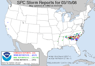 Basically, in the course of those 2 days, "one man was killed near downtown Atlanta. Two other deaths took place on March 15 in the northern Atlanta suburbs from the second, larger round of severe weather and tornadoes. In total, 45 tornadoes were confirmed over the 24 hour period from eastern Alabama to the Carolina coast, with most of the activity concentrated in the Metropolitan Atlanta area, the Central Savannah River Area and the Midlands of South Carolina." ~source A moderate risk had been issued for March 15th, but it was elevated to a high risk for severe weather over the course of the day.
It was a memorable weather day for Georgia.
~Dew
Monday, March 16, 2009
The anniversary of the Atlanta tornado outbreak
Tuesday, March 18, 2008
THE PICTURE of the downtown Atlanta tornado...
The historic "Atlanta tornado photograph" by Shane Durrance can be purchased through this link... http://www.atlantatornado.org/.
THE PHOTO HAS BEEN REMOVED BY THE REQUEST OF SHANE DURRANCE (AND TO RESPECT COPYRIGHT LAWS)... VISIT HIS SITE LINKED THROUGHOUT THIS BLOG. ACCORDING TO SHANE: I am working hard on getting a new website up and running for prints to be ordered. Prints will be able to be purchased from www.shanedurrance.com hopefully as early as next week.
Well, I have seen this photograph in several places now, so I decided to share it a little more openly. Alabama Mike gave me the link to the photograph that was taken by Shane Durrance of the downtown Atlanta tornado on March 14. The link I have offered here is the location where I copied the image from. Apparently, Mr. Durrance was photographing lightning at the time (according to the Weather Channel, where they showed this photograph this morning), and he just happened to catch the tornado in the far left side of the shot as it was in the downtown area. You can see what appears to be a debris cloud at the base near the tall buildings, but with it being nighttime and a still shot, it is difficult to be certain. Here is the interesting part that I find rather humorous... When I went to check out 11Alive WXIA's website (since the site Mike shared, referenced them as the source of the photograph) to see what the deal was, they have a slightly differently cropped shot of the same picture of the EF-2 tornado that tore through downtown Atlanta.
THIS PHOTOGRAPH HAS BEEN REMOVED AT THE REQUEST OF THE PHOTOGRAPHER, CLICK ON THE ARTICLE LINK TO SEE WHAT I AM TALKING ABOUT.
You can see where 11Alive almost cropped out the tornado... and they refer to that gray section in the center as being the tornado... and I quote: Shane Durrance's shot of the tornado that hit downtown Atlanta on March 14. The tornado is the light-gray vertical strip in the center of the picture.
An interesting point with this is that that light gray vertical strip in the center of the picture doesn't even appear to be touching the ground, and there is certainly no associated debris cloud, which there obviously would have been in light of the fact that it was tearing through downtown Atlanta and debris (including HUGE debris) is now covering the streets there... Did they even bother to have a meteorologist look at the pic before posting their nonsense about it online??? On that same 11Alive website... I did find this blog posted by one of the 11Alive staff, Paul Ossmann, where he contradicts the writers on the other page by saying... An image of the tornado that hit downtown Atlanta on Mar. 14, 2008 by Shane Durrance. The tornado itself is on the left side of the image.
Anyways, I just wanted to shed some light on the whole tornado shot. Kudos to Shane for the terrific photograph! Talk about timing... Oh, and I should share that since I am an NBC Augusta spotter, I get handy dandy newsletters with cool information... They shared in that this photograph of the Wrens EF-2 tornado on March 15th, and they shared this image with me of the tracks of the various tornadoes.
  They also sent a summary of the tornadoes in that CSRA:
 Saturday, March 15th, 2008 will be a day to remember. Five tornadoes covered ten counties over the CSRA. Here's a summary of the historical Georgia-Carolina tornado outbreak.
It looks like Peachtree City National Weather Service has the Preliminary Storm Reports posted for the March 14th and the March 15th tornadoes, including the Polk/Floyrd/Bartow County EF-3 tornado that took two lives. Feel free to check those out.
Tornadoes:
1) Northern McCormick County rated EF-0, moved into northern Edgefield County increasing in strength to an EF-1.
2) North McDuffie County rated EF-0, moved to northern Columbia County still at EF-0, then to northern Aiken County (near Belvedere, Clearwater) strengthening quickly to an EF-2 tornado, then continuing east through Barnwell County as an EF-2, and into Bamberg County reaching EF-3 strength entering Orangeburg County.
3) Jefferson County (near Wrens) rated EF-2, moved into northern Burke County (near Keysville) still as EF-1.
4) Central Burke County (Burke's second tornado) near Waynesboro moved southeast as an EF-1.
5) Allendale County from the town of Martin to Fairfax as EF-2.
Now, onto current weather, it appears that the Texarkana (Texas/Arkansas/Louisiana) region is under fire today with the SPC having placed that region under a MODERATE risk for severe weather, discussing the massive shear values expected to be the dominant dynamic contributing to the potential for LARGE HAIL...DAMAGING WIND GUSTS...AND TORNADOES...WITH POTENTIAL FOR A FEW STRONG TORNADOES.
 A public severe weather outlook has been issued there for today, so folks in that area of the country should be vigilant in watching the conditions around them. The threat spreads tomorrow into almost all of Georgia and Alabama, all of the Carolinas and Virginia and part of Tennessee. Although instability is forecasted to be extremely weak, the shear along the warm sector (did I mention it is forecast to hit 80 degrees today?), will support the development of supercells and bowing segments, which would suggest a strong possibility of a few tornadoes and some damaging winds... these storms are expected to race through the area.
Should be an interesting day tomorrow locally, but today things could get bad for those to my west... Stay tuned...
Tornado watch for Texarkoma issued this morning... THIS IS A PARTICULARLY DANGEROUS SITUATION... DESTRUCTIVE TORNADOES...LARGE HAIL TO 2 INCHES IN DIAMETER... THUNDERSTORM WIND GUSTS TO 80 MPH...AND DANGEROUS LIGHTNING ARE POSSIBLE IN THESE AREAS.
Toodles,
~Dewdrop


