The heavens declare the glory of God;
the skies proclaim the work of his hands.
-Psalm 19:1

Do you know that God controls the clouds and makes his lightning flash?
-Job 37:15


Showing posts with label cold weather. Show all posts

Thursday, January 07, 2010

The grips of SDS

SKY WATCH FRIDAY time! Welcome all sky fans!!! I truly appreciate your visit and comments. I might not have time to respond to you, but I will try my best to visit!!!

Our hosts: Klaus Sandy Sylvia Wren Louise Fishing Guy

Thanks, also,to Dot and Tom, who were instrumental in the success of this blogging event. You should definitely come fly with us!
I'm so tired of talking about the cold. It's there. It will continue to be there after today. My toes are numb, my fingers feel brittle. I'm running out of winter wear. (My sweaters have to be dried flat.) As a result, I have posted a June shot of yummy juicy boiling cumulus clouds in a nostalgic black and white, remembering the fonder days when Jack Frost wasn't nipping at my nose, and moisture, lift and instability combined in delightful ways to entertain me... Yes, folks, my SDS is bad. What's SDS? Ahhh, it's a common acronym in the storm chasing community, which stands for Supercell (Storm) Deprivation Syndrome. Plenty of storm chasers have written about this syndrome which grips us during the winter months, while storms are but a distant memory. You can see in Steve Miller's (TX) chart here, that we are approaching the time of highest incidence of this suffocating disorder.Unfortunately, during times of El NiƱo, such as now, the symptoms can be extremely severe. (At least there's severity somewhere right.) Some of my symptoms include, but are not limited to:


1. Innate fascination with the "little tornado" in the bathtub drain
2. Secretly watches videotape of "Twister" repeatedly (and know every line...)
3. Drags feet across carpet and touches metal object just to see the little CG lightning bolt.
4. Constantly testing alert tone on wx radio to make sure it is working
5. Simulates hail by throwing ice cubes up in air allowing them to fall upon the pavement, chase vehicle or the patient him/herself.
Unfortunately, the only known cure is to witness a supercell, in person... given the Dewvoid effect, I might be in big trouble.

OK, OK, I'll talk about the cold now. I woke up to 21°F temps and a hard freeze. Tomorrow, I will awaken to freezing temps. Snow is in the forecast for parts of Georgia, as a second ridiculously intense cold front presses in hot on the heels of the one we are just coming out of... I haven't seen a cloud in DAYS! Nothing but clear skies and teeth chattering cold. Initially, there was talk of snow flurries in my neck of the woods, but the National Weather Service in Tallahassee has done away with that talk, saying only that lagging rain up against the approaching cold front could offer sleet, but that isn't highly likely and the chance for snow is almost nil. Here is what they have said. ...
WITH IT BEING SO COLD THERE HAVE BEEN A LOT OF INQUIRIES AS TO THE POTENTIAL FOR FROZEN PRECIP. DESPITE THE CONTINUATION OF BELOW-AVERAGE TEMPERATURES TODAY...IT IS ALREADY TOO WARM FOR SLEET OR SNOW AS SIGNIFICANT WARMING HAS BEGUN ABOVE THE SHALLOW COLD BOUNDARY LAYER. THE TROPOSPHERE WILL REMAIN TOO WARM TO SUPPORT FROZEN PRECIP UNTIL THE EARLY MORNING HOURS FRIDAY BEHIND THE ARCTIC COLD FRONT. ALL OF THE GUIDANCE SHOW THIS...AND THERE IS JUST THE SMALLEST OF CHANCES FOR A BRIEF PERIOD OF LIGHT SLEET WHERE (IF) THE ARCTIC AIR REACHES ANY LAGGING PRECIP. (THE COLD LAYER WILL LIKELY BE TOO SHALLOW FOR SNOW AND NOT COLD ENOUGH FOR ACCUMULATING SLEET).
As for my initial concerns of rain with freezing temps causing an icy mess locally, the Weather Service has addressed that concern as well...
THERE HAS ALSO BEEN SOME CONCERN EXPRESSED ABOUT THE POTENTIAL FOR WATER FROM TONIGHTS RAIN FREEZING ON THE ROADS FRIDAY MORNING IN AL AND GA. BECAUSE THE QPF IS LESS THAN A QUARTER OF AN INCH...AND BECAUSE GUSTY WINDS AND FALLING HUMIDITY ARE FORECAST TO DEVELOP QUICKLY AFTER THE FRONTAL PASSAGE...THERE SHOULD BE ENOUGH EVAPORATION AND GROUND ABSORPTION TO PREVENT THIS FROM BEING A SIGNIFICANT THREAT. IT WILL BE COLD AND BREEZY FRIDAY WITH HIGHS STRUGGLING TO REACH 40 DEGREES...AND WIND CHILL VALUES NEAR OR BELOW FREEZING THROUGH MUCH OF THE DAY.
Try and stay warm,
~Dewdrop

Wednesday, January 06, 2010

COLD!

The cold spell continues, and I am running out of cold weather clothes!!! Though there is talk about a slight reprieve for the day on Thursday (not above average temps still, expect low 50's), the warning of a worse cold blast over the weekend hangs a dark cloud over the minimal break. Tallahassee's Weather Service office has taken the snow references out of our forecast and left it with rain and barely above freezing temps.

IT IS NOT ENTIRELY OUT OF THE QUESTION FOR A LITTLE BIT OF SLEET TO OCCUR ALONG THE BACK EDGE OF THE PRECIP BAND EARLY FRIDAY MORNING...BUT THE LIKELIHOOD AND IMPACT OF THIS SEEM TOO SLIGHT TO FORECAST AT THIS TIME.
If that holds, school will most likely not be cancelled, unless they consider what's on the other side of that rain... Now, if you check out Jacksonville's Weather Service, they seem to be of a varying opinion. Their graphic forecast paints a picture of failing white stuff on Thursday night.
...should enough cold air remain in place, a wintry mix may occur across portions of Southeast Georgia with sleet or freezing rain possible before sunrise followed by a few snow flurries. Freezing temperatures Friday morning and wet ground may cause ice on roadways- especially on bridges and overpasses- which would create hazardous driving conditions. Interests should continue to monitor this evolving weather event.
Aside from the ridiculous cold weather, which I am not a big fan of... The National Weather Service nationally, effective yesterday, has raised (or in some places kept the same) the parameter for severe hail to one inch size or quarter-sized hail. Locally, it was only 3/4" or penny sized until yesterday's change. Notice that hail is not compared to marbles, but coins which are much less variable.

Have a warm day, or try to.
~Dewdrop

Tuesday, January 05, 2010

As I type this, my fingers are shattering into millions of pieces

As for the update on Mini-Dew and her travels into her first encounter with snow... she and her father ended up detouring around Charleston, because conditions were just too rough there. They added about 4 hours to the route in the process, but it was worth it to arrive safely in Pittsburgh last night. Nevertheless, they did encounter lane closures on I79 and some patches of white-out conditions where the road indicators were her father's only guide. It was sure a relief to speak with her safe and warm at grandma's house. Snow continues to pummel the area, and Mini-Dew is excited about sledding on some hills they spotted along the way.

Locally, we are experiencing colder temperatures here than in many of the northern states. ... and the wind chill temps are even worse. Geographically, things are all out of whack. It's colder in Jacksonville than in Bangor. Insanity!The National Weather Service in Tallahassee has issued a Hard Freeze Warning, Hazardous Weather Outlook, Fire Weather Watch, Red Flag Warning and (SHRIEK!) a Wind Chill Advisory!

A WIND CHILL ADVISORY MEANS THAT VERY COLD AIR AND WINDS ABOVE 5 MPH WILL COMBINE TO GENERATE LOW WIND CHILLS. THIS COULD RESULT IN FROST BITE AND LEAD TO HYPOTHERMIA IF PROPER PRECAUTIONS ARE NOT TAKEN. IF YOU MUST VENTURE OUTDOORS... MAKE SURE YOU WEAR A HAT AND GLOVES.
Our departures from the normal temperatures are ridiculous and demonstrate the gravity of this direly cold situation.


I keep hearing that cold is relative, and I know that to be true. The south isn't designed for this kind of cold. Al Gore can kiss my frozen toes. They are still keeping s#@w verbiage in our forecast, not as a likelihood, but as a chance. My friend, last night, actually texted me a picture of her television, which showed clearly that SNOW was in her forecast for Friday, according to TWC. For her, it's a bit of irony, she spent the holiday with her family seeking out snow (something the kids had never seen), which they ended up finding in abundance in North Carolina. Unfortunately, rain is the more likely outcome, and rain and freezing temperatures spell a disastrous situation.
THE HIGHEST DAYTIME TEMPERATURES WILL BE ON THURSDAY WITH MID TO UPPER 50S AS WINDS SWING AROUND TO A SOUTHERLY DIRECTION AHEAD OF A STRONG COLD FRONT. THIS FRONT WILL ALSO BRING A CHANCE OF RAIN THURSDAY. THERE CONTINUES TO BE A VERY SLIGHT CHANCE THAT THE RAIN MAY CHANGE OVER TO LIGHT SNOW OR LIGHT SLEET OVER PORTIONS OF THE TRI-STATE REGION THURSDAY NIGHT INTO EARLY FRIDAY MORNING.
Worse yet, this cold front means that the worst is yet to come.
AS COLD AS IT HAS BEEN THE PAST FEW DAYS...THE COLDEST TEMPERATURES ARE EXPECTED FRIDAY INTO THE WEEKEND WITH MINIMUM TEMPERATURES IN SOME INLAND LOCATIONS POSSIBLY DROPPING INTO THE LOWER TO MID TEENS AND HIGHS IN THE UPPER 30S TO LOWER 40S
I am now, officially, geographically misplaced without a cause. I live in south Georgia because I am a cold weather wimp. After years of harsh Boston weather, bitter, frigid cut-through-you-like-a-knife-kind-of-cold, I was eager to get to a place where that doesn't happen, so I settled in south Georgia. Boy, was I misled!

S-s-s-s-stay w-w-w-w-w-warm,
~Dewdrop-cicle

Monday, January 04, 2010

Freezing in the New Year!!

The jet stream has dipped well into southern Florida, bringing with it a frigid blast of Arctic air, which we were far from prepared for... I awoke to 27° outside, and our high is not expected to get above 44°. Currently, our temps are still below freezing, with clear skies!!! I know all you folks up north are thinking, WIMPS! We are simply not equipped or prepared for the cold spell we are currently enduring and have yet to face. Many children in south Georgia don't even have winter coats (don't generally need them). Boots, scarves, hats and gloves have already been ripped from the shelves by stockers to make room for the summer lines... need flip flops? We've got those on the shelves. Shorts? Sure, we've got 'em... Winter clothes...? Uh... sorry, we didn't expect winter weather... in WINTER! Someone left the A/C running at my office when they left on Thursday, so the first person to arrive faced 54°... inside!!! We are currently under a hard freeze warning. Our heating systems (heat pumps predominantly) are not designed for extended periods of extreme cold. Sure, up north, it gets cold all the time, it s#@ws and they frequently see negative temperatures, but because of that, they have the clothing, the boots, the furnaces... we haven't got any of that!!! If it were a quick thing, over soon, it wouldn't be so bad, but we have a second worse wave coming at the end of the week. They are actually forecasting a chance of SNOW?! on Thursday night... HERE!

...TUESDAY THROUGH SUNDAY...
VERY COLD CONDITIONS WILL CONTINUE TO GRIP THE REGION FOR MUCH OF THE WEEK. A HARD FREEZE (up to 14 hours of freezing temps) IS EXPECTED AGAIN TUESDAY NIGHT WHEN MINIMUM TEMPERATURES ARE FORECAST TO DROP INTO THE UPPER TEENS ACROSS MOST INLAND AREAS. ALTHOUGH IT WILL NOT BE QUITE AS COLD ...SUB-FREEZING TEMPERATURES WILL CONTINUE TO IMPACT THE REGION WEDNESDAY NIGHT AS WELL. AN AREA OF LOW PRESSURE IS FORECAST TO MOVE EAST ALONG THE GULF COAST THURSDAY AND THURSDAY NIGHT. LIGHT RAIN IS EXPECTED THURSDAY WITH THIS SYSTEM AND THERE IS THE POSSIBILITY THAT THE RAIN COULD BRIEFLY CHANGE OVER TO LIGHT SNOW OR FLURRIES BEFORE THE MOISTURE MOVES OUT OF THE REGION THURSDAY NIGHT INTO EARLY FRIDAY MORNING. A RE-ENFORCING COLD AND DRY AIR MASS WILL FILTER INTO THE AREA FRIDAY THROUGH THE WEEKEND.
I would expect school closures, since as I said, kids just aren't equipped for this type of weather down here. It becomes a dangerously cold situation for them.

Now, Mini-Dew is headed up to Pittsburgh today with her father, attending her grandfather's funeral (after he sustained a head injury when falling on ice before Christmas). They are currently being inundated with snow; the remnants of a low pressure system off the coast turned out to be a blizzard up there over the weekend. Unfortunately, those remnant snow bands over Pittsburgh have earned a special weather statement.
THE NATIONAL WEATHER SERVICE SAYS THERE CONTINUES TO BE BANDS OF HEAVIER SNOW SHOWERS SHIFTING SOUTHEASTWARD ACROSS THE AREA. TRAVELERS NEED TO BE ALERT FOR CONDITIONS SUDDENLY TURNING HAZARDOUS AS THE HEAVIER SNOW SHOWERS CAN CAUSE LOW VISIBILITY AND SLIPPERY SNOW COVERED PAVEMENTS IN SNOW AND BLOWING SNOW. SOME SPOTS COULD PICK UP A QUICK NEW INCH OF SNOW ACCUMULATION THROUGH 10 AM.

DRESS WARM AS WIND CHILLS ARE NEAR ZERO. KEEP HANDS AND FACE COVERED WITH GLOVES AND HATS.
My child is traveling into that?! She is a south Georgia kid, born and raised! She will certainly turn into a Mini-Dewdropcicle!!!

5:00PM my child should be riding into the worst of the snow in about an hour in Charleston, WV. She is in Bluefield, WV now, which is right at the line of Virginia and West Virginia.

Stay warm...
~Dewdrop

Wednesday, January 30, 2008

Windy day... sun dogs.... chasing the sun

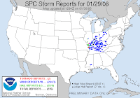
Well, my suspicions were accurate... no weather for me. I got a decent rain last night, I think (still no operational rain gauge... I need to remember to get that fixed before CoCoRaHS starts up in Georgia). The ground was wet, but I did not awaken to any thunderous claps in the night (not that I am an easy one to awaken). It was fun to watch the temperature fall this morning. It dropped 9 degrees during the hour that I watched TWC this morning. The high today was 62, which happened at about 6:30AM... it's all down hill from here, and the wind is pushing hard. Nothing like what occurred yesterday well north and west of here. 204 wind reports... with winds rating at 80mph in some places. Check out the storm reports by clicking on the map. Wild, wild weather we are having...

Since Ma Nature hasn't given me any weather to chase, I have taken to chasing the sun, once again. It's nice when it sets a little bit later, so I have time to get to a good viewing point, and when it's not so late that I am busy with Mini-Dew when it happens. My location for shooting sunsets is constantly changing because of development in the area. My beautiful views are being overtaken by "growth". As it is, my current view has an eye sore of a billboard smack dab in the middle of it. I might have to seek out some western views this weekend. At my current location, I have truck drivers looking at me like I am a fool. Maybe, I am... I was able, once again, to see sun dogs, not as impressive as some others I have been able to see, but I did get to see the faint sun dog on the other side this time, and I had a nice display of colors in the remnant of a contrail. You might have to click on the image and view it larger in order to see it well.Of course, I have to give kudos to Mike Hollingshead, who has shot the best sun dog with halo, I have ever seen (It's at almost the bottom of the page of several other pics that are equally impressive and awesome). I don't know how he does it, but I wish I had the talent for it, like he does... maybe it's another matter of my geographic misplacement. Great work, Mike. I love sun dogs.

Then, there is this morning. I mentioned that there was a nice rain last night... well, that cleared up, leaving cool air and wind, and a beautifully magnificent field of altocumulus clouds, covering the sky like a warm cottony blanket. For some reason, altocumulus clouds remind me of my favorite clouds, mammatus, so I always photograph them, when I see them. The fluffy white altocumulus against the crisp blue sky was a nice contrast. Of course, I was sitting at the stop sign in my neighborhood shooting pics out my window, when a neighbor drove by sharing the all too common "What-on-Earth-are-you-doing?! look" that I have come to know and love. I responded with a big cheeser grin. Do people not see the same sky I see? How can they not stop to appreciate it once in a while? God's canvas. Too magnificent of an art display to miss out, imo.

As for weather... well, it looks like tomorrow is forecast to be a big day, well to my west, and then an encore presentation, well to my east. Here I sit, in the middle basking in the nothingness of the Dewvoid... seriously, the slight risk covers everything far west of here, then things picks back up on the Georgia coast. Nothing I can Dew about it.

...CSTL CAROLINAS/GA... A LWR SVR PROBABILITY AREA WILL LIKELY EVOLVE ALONG THE CSTL PLAINS OF SERN GA NEWD INTO ERN NC THU NIGHT. ISOLD TORNADOES COULD ACCOMPANY THE STRONGER STORMS BEFORE THEY BECOME ELEVATED.
It's laughable how the weather seems to go around me... Trust me, if I chase it, it will vanish.

Have a great day!
~Dewdrop