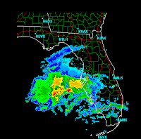
 STREAMLINE ANALYSIS OVER THIS FEATURE SHOWS A DISTINCT LINE OF CONVERGENCE INTO THE CIRCULATION THAT LINES UP WELL WITH THE PREVIOUSLY MENTIONED LINE OF CONVECTION. DUE TO THE LOCATION OF THIS FEATURE BEING FURTHER SOUTH THAN PREVIOUSLY THOUGHT...WILL LIKELY UPDATE THIS MORNING TO SLIGHTLY REDUCE POPS AND QPF OVER THE AREA.Yep, sure enough, there it is, and here we are...
  Welcome to the land of no weather, right? At least folks in Central Florida can desperately use the rain. Storm videographer, Jeff Gammons posted a blog today that explains the true need in Florida for rain. Hopefully, these scattered showers and storms (unfortunately with a chance for some fire-sparking lightning) will help (even though they were supposed to come up our way... I won't hold it against you Jeff, weather hog!) Oh, but that's not the only reason I mention Jeff here... I watched his "September's Fury" DVD last night, which was an excellent compilation of coverage of Hurricanes Frances, Ivan and Jeanne, as they bulldozed Florida in September 2004. This was my free DVD for reviewing his blog... That offer has ended, but you can purchase his DVD's here... They are pretty awesome, even if the prospect of me chasing a hurricane, combined with hubby watching pieces of the DVD scared him to death... OK, enough advertising for Jeff... Back to the weather...
Bryan said: ON THE BRIGHT SIDE BOTH MODELS ARE SHOWING A CONTINUED SUPPLY OF DRY LOW LEVEL AIR DRAINING DOWN INTO OUR GEORGIA ZONES THROUGH THE DAY RESULTING IN A NEED TO LOWER POPS...ESPECIALLY THE FIRST HALF OF THE DAY. Wait just one cotton pickin' minute... Did he say, "on the bright side"...? Bryan, we need rain, how is that a bright forecast? Ahh, but he redeems himself when he says: BY LATE IN THE AFTERNOON AND ESPECIALLY THE EVENING AND FIRST HALF OF THE NIGHT...THE MID LEVEL SHORTWAVE CURRENTLY OVER TEXAS BEGINS TO SWEEP EAST ALONG THE GULF COAST AND SHOULD BRING AN INCREASING THREAT FOR SHOWERS AND POSSIBLY A FEW EMBEDDED THUNDERSTORMS FURTHER INLAND ALTHOUGH A WASHOUT IS CERTAINLY NOT EXPECTED. ... and for Wednesday... MOIST LOW LEVEL AIR BEHIND THE BOUNDARY COMBINED WITH STEEPENING MID-LEVEL LAPSE RATES SHOULD BE ENOUGH FOR SCATTERED SHOWERS/ THUNDERSTORMS TO DEVELOP DURING THE AFTERNOON ACROSS THE AREA. Some continuation of the showers might continue into early Thursday, but then a ridge sets up for most of Thursday and Friday, except for some possible sea breeze convection on Friday... Won't be ridging for long though, as a strong low pressure system in the plains stemming from the trough out that way will push our way and create a shot at showers and thunderstroms for late Saturday. It's early still, but it's something to watch. I should drive through it... fabulous. Sunday will see yet another round of cool temps... I won't be here, so I'm not worried about it... I guess it's time to start checking Vegas weather... ;-)
Sorry for the post delay... I was side-tracked by meetings this morning.
Have a lovely day!
~Dewdrop
Tuesday, April 10, 2007
Not so bright of a side, imo...
Subscribe to:
Post Comments (Atom)


Thanks for the cool comments and PLUG! Glad you enjoyed the DVD.
ReplyDeleteLooking like some of these FLorida fires might see some rain this afternoon. Developing around me now and large area moving in from the Gulf. I'm loving it!
Expect large severe weather event over GA while your in Vegas.
You're welcome... I hope y'all get something out of that mess and it helps those fires.
ReplyDeleteLarge severe weather event while I'm in Vegas??!! Ha ha, Jeff, very funny! Hey, though, plenty of sand in Vegas, right? Might be able to catch a couple of dust devils... lol
Countdown to Celine... 5 days! Oh yeah!