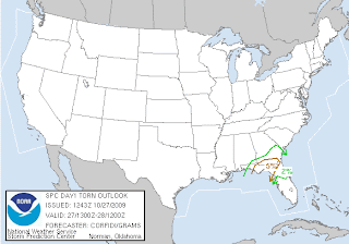
Well, there I was about to give a more current (since yesterday) update about Halloween weather, when Rick mentions tornado watch... WHAT?! TORNADO WATCH!!! HERE?! NOW?! Yes.  Yes, folks, until 6PM for a small area of the southeast, including my very own county. Remember that a tornado watch means that conditions favor the development of tornadoes, and you should be mindful of rapidly changing conditions.
DISCUSSION...TSTMS EXPECTED TO CONTINUE DEVELOPING IN MOIST...STRONGLY-SHEARED LOW LVL WAA ZONE ALONG CONFLUENCE AXIS OVER THE NERN GULF OF MEXICO AS REGION IS GLANCED BY RED RVR VLY SHORTWAVE IMPULSE. POTENTIAL WILL EXIST FOR SCTD STORMS WITH LOW LVL ROTATION AND POSSIBLE TORNADOES AS W/E FRONT NOW ALONG THE CST OF THE FL PANHANDLE MOVES SLOWLY NWD.
Be ready to seek shelter. At this time, we have a solid deck of status clouds and a persistent drizzle, which will prevent necessary heating for instability, but if we get a break in this cloud deck... and it's timed enough before the arrival of this front, we could have an explosion of weather. You see that currently, the slight risk for severe weather exists right on top of me. Feel free to click on the below graphic for a current look. The tornado potential stands at 5% for my area. That means that this first wave is expected to clear up and the big one behind it could drop a few naders. Remember, the watch continues until 6PM, so do not let your guard down, especially once it clears here in the south. Below is a map of the tornadic threat.
 Have a safe day! I'll have one eye on weather.
~Dewdrop
Tuesday, October 27, 2009
Tornado watch in the south
Subscribe to:
Post Comments (Atom)


No comments:
Post a Comment
Dew comment, please...