I hope everyone had a wonderful Thanksgiving, full of family, friends and lots of blessings. We certainly did, and it was absolutely wonderful.  As a result, I've been away from the blogosphere for a slight time, which encouraged a weather hiatus of sorts, leaving me refreshed and excited about today's severe weather potential in the south. Currently, I am at over 2" of rainfall since last night, and there doesn't appear to be any relief in sight. If we get a clearing in this before the main storm line approaches, we can expect some volatile weather today. Welcome back to weather watching Dewdrop... just barely outside a tornado watch box.
 The current tornado watch covers a portion of the southeast, including an area of south west GA, to my west, the FL panhandle and lower AL. I expect that threat to travel eastward with the movement of the system. We are told to expect flooding rain, hail and tornadoes.The current tornadic threat is a significant 10%.
  We don't generally see that kind of probability in my neck of the woods. You can click on the tabs on the link that the graphic brings you to, to see probabilities for hail and wind. The text of the outlook isn't powerful, but the chance exists, and they have highlighted that. Be vigilant and watchful, ready to get to safety.
I have a lot of catch up to do, but I'd like to get a chance to share some Thanksgiving shots soon.
Have a great day!!!
~Dewdrop
Wednesday, December 02, 2009
Welcome back weather
Tuesday, October 27, 2009
The Dewvoid strikes again...
Well, the Dewvoid appears to be prevailing. As I mentioned, our solid stratus deck has done its work to prevent the necessary instability to get things rolling in these parts. In these parts, we refer to that effect as the DEWVOID. The DEWVOID is loosely defined as the apparent weatherlessness that chases storm chaser, Dewdrop. The DEWVOID effect can single handedly kill a high risk PDS threat and render it nothingness.
Check out the wording in the mesoscale discussion just issued for my neck of the woods, and allow me to translate... Feel free to click on the image above if you don't believe me.
MAIN CONVECTIVE BAND CONTINUES MOVING EWD ACROSS THE ERN GULF/SERN CONUS (toward the area of apparent Dewvoidness)...WITH SOMEWHAT STRONGER/MORE CELLULAR CONVECTION FROM SWRN GA SWD (in other words, it is strong to severe away from here). EVEN ACROSS THIS REGION (the Dewvoid region) HOWEVER... WEAK INSTABILITY (what did I tell you?)-- AS INDICATED BY THE LACK OF INLAND LIGHTNING ATTM (and the presence of Dewdrop)-- CONTINUES TO
Ugh.
HINDER THE DEVELOPMENT OF ISOLATED/STRONGER STORMS. LIKEWISE...A DECREASE IN INTENSITY WITHIN THE ONGOING CONVECTION HAS BEEN NOTED OVER THE PAST COUPLE OF HOURS (as the system approaches Dew -- gasp, what a surprise!).
WHILE SHEAR PROFILES REMAIN FAVORABLE FOR ROTATION WITHIN ANY SUSTAINED/STRONGER UPDRAFT (as if!)... A CONTINUED DECREASE IN CONVECTIVE INTENSITY IS FORECAST GIVEN THE LACK OF INSTABILITY (Dewvoid effect expected)... AND GIVEN THE STRONGER LARGE-SCALE FORCING CONTINUING ITS NEWD SHIFT AWAY FROM THIS REGION (The Dewvoid will actually be driving the storm away!). WHILE AN ISOLATED/BRIEF TORNADO REMAINS POSSIBLE (HA!) OVER THE NEXT COUPLE OF HOURS...THREAT SHOULD CONTINUE TO SLOWLY DIMINISH THIS AFTERNOON (as it continues to approach Dew).
~Dew
Tornado watch in the south
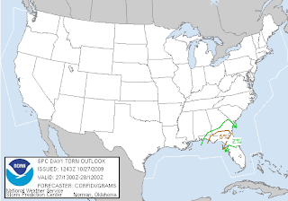
Well, there I was about to give a more current (since yesterday) update about Halloween weather, when Rick mentions tornado watch... WHAT?! TORNADO WATCH!!! HERE?! NOW?! Yes.  Yes, folks, until 6PM for a small area of the southeast, including my very own county. Remember that a tornado watch means that conditions favor the development of tornadoes, and you should be mindful of rapidly changing conditions.
DISCUSSION...TSTMS EXPECTED TO CONTINUE DEVELOPING IN MOIST...STRONGLY-SHEARED LOW LVL WAA ZONE ALONG CONFLUENCE AXIS OVER THE NERN GULF OF MEXICO AS REGION IS GLANCED BY RED RVR VLY SHORTWAVE IMPULSE. POTENTIAL WILL EXIST FOR SCTD STORMS WITH LOW LVL ROTATION AND POSSIBLE TORNADOES AS W/E FRONT NOW ALONG THE CST OF THE FL PANHANDLE MOVES SLOWLY NWD.
Be ready to seek shelter. At this time, we have a solid deck of status clouds and a persistent drizzle, which will prevent necessary heating for instability, but if we get a break in this cloud deck... and it's timed enough before the arrival of this front, we could have an explosion of weather. You see that currently, the slight risk for severe weather exists right on top of me. Feel free to click on the below graphic for a current look. The tornado potential stands at 5% for my area. That means that this first wave is expected to clear up and the big one behind it could drop a few naders. Remember, the watch continues until 6PM, so do not let your guard down, especially once it clears here in the south. Below is a map of the tornadic threat.
 Have a safe day! I'll have one eye on weather.
~Dewdrop
Wednesday, June 17, 2009
Pretty skies and severe weather
I would like to start today's message by saying the Vonage is a company of crooks. They have immoral business practices, and I am at my wit's end with them... if anyone can dispute that with credible facts, I welcome that. I have just filed my dispute with the Better Business Bureau. Grr...

 Pretty random, eh? (No, I'm not Canadian.) Anyways, I don't have the radar capture, so you'll just have to trust me. Well, then, this amazing thing happened in the southern sky... the clouds lit up with all this amazing texture and an array of colors, and brought about this truly heavenly scene...
As the evening wore on, and we were about to sit down to eat, I put the doggone dog outside, and I looked up to see an amazing explosion of cloud to cloud lightning, in that amazing structure now to my southeast. I mean, the whole cloud had streaks of lightning lacing through it, brilliantly shining through in a lavender glow. I did the only thing I could do... I raced inside for my camera. Unfortunately, it had slowed down in frequency, and our mosquito population prevailed. I only got the tail end of one strike, not even worth posting, which is a downer, but... oh well. It was incredible to watch. So no, we're not getting all the severe weather that others are getting, and yes, we are dealing with heat indices approaching 110°F (yes, you read that right), but we still have AWESOME skies! I'll take it.
Speaking of severe weather, the Storm Prediction Center has outlined an area of moderate risk for severe weather once again.
THE NWS STORM PREDICTION CENTER IN NORMAN OK IS FORECASTING THE DEVELOPMENT OF...LARGE HAIL...DAMAGING WINDS AND A FEW TORNADOES OVER PARTS OF THE CENTRAL PLAINS LATER TODAY AND TONIGHT.
Once again, geographically misplaced, and a slight risk extends into ALL of Georgia... hey, it expanded, I am in the slight risk! :D
SOUTHWESTERN IOWA
EXTREME NORTHERN KANSAS
NORTHWEST MISSOURI
MUCH OF NEBRASKA
Toodles,
Dewdrop
Friday, June 12, 2009
Significant part of southeast under a risk for severe weather
 Much of the southeast is included in a slight risk for severe weather today, but the SPC has just issued a discussion indicating that the blue outlined area in Oklahoma, Kansas, Arkansas, Missouri will be upgraded to a moderate risk. Looks to me like that are already getting some significant wind with a punchy looking bow echo that is currently raging across Oklahoma, where wind and hail reports are already pouring in.
 The instability forecast is through the roof with MLCAPE over 4000J/KG!!!! That is some seriously unstable air.
 MAINTAIN AN ORGANIZED RISK OF SEVERE STORMS THROUGH THE AFTERNOON AND EVENING AS ACTIVITY SPREADS INTO PARTS OF WESTERN TN/NORTHERN AL/NORTHERN MS. FORECAST SOUNDINGS SUGGEST PARAMETERS FAVORABLE FOR VERY LARGE HAIL...SIGNIFICANT DAMAGING WINDS...AND ISOLATED TORNADOES ACROSS THIS AREA. AN UPGRADE TO MODERATE RISK MAY OCCUR LATER TODAY AS THE CORRIDOR OF GREATEST THREAT BECOMES MORE CLEAR AND IF STORMS INTENSIFY AS CURRENTLY EXPECTED.
... which has happened...
Not much talk of tornadoes though... so Vortex2 might not get a great finale as they might have hoped. REGION WILL BE UPGRADED TO A MODERATE RISK FOR THE 1630Z CONVECTIVE OUTLOOK.
REGIONAL SOUNDINGS INDICATED THE PRESENCE OF ANY ALREADY STRONGLY UNSTABLE AIR MASS WITH MUCAPE OF 3000-4000 J/KG. 12/00Z HIGH RESOLUTION MODEL RUNS HAVE VERIFIED REMARKABLY WELL WITH THE EVOLUTION OF NERN OK BOW ECHO WITH THESE DATA TAKING SYSTEM THROUGH AR INTO NRN MS TODAY. GIVEN THE DEGREE OF INSTABILITY AND 40-50 KT OF DEEP-LAYER SHEAR...SETUP WILL BE FAVORABLE FOR A CORRIDOR OF SIGNIFICANT WIND AND HAIL DAMAGE. ADDITIONAL STORMS DEVELOPING DOWNSTREAM FROM BOW ECHO WILL ALSO POSE A RISK OF LARGE HAIL AND DAMAGING WINDS.
Have a great weekend!
~Dewdrop
Thursday, June 11, 2009
Thunderstruck...
 SKY WATCH FRIDAY time! I am busy busy with stimulus yuck, so I might not get a chance to say hi. Please don't take offense. Our hosts: Klaus Sandy Ivar Wren Louise Fishing Guy
Thanks, also,to Dot and Tom, who were instrumental in the success of this blogging event. You should definitely come fly with us!  I figured that with thunderstorms expected to dampen about 2/3 of the country today (much of it severe, even, including in much of Georgia--slight risk for severe weather exists inside the green area), I would post a pic of one of my favorite thunderstorms. It was a very isolated thunderstorm with a large and dramatic and perfectly time explosion of cumulonimbus.
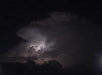 This was such a memorable storm for me. I was amazed first by its impressive size. Then, of course, the sun hitting it just right, offering a Georgia peachy thunderstorm. At one point, there was a faint field of mammatus present, which I haven't counted in my 4 times because it lasted 2 seconds, and it wasn't terribly impressive. The storm fired cloud-to-cloud lightning for more than an hour, and it was completely stationary. It lit up the sky as day turned to night.
  OK, OK, it was pretty spectacular with the sunset lighting it up with pink and orange (and everything in between). It was just so short-lived.
 Looking at it though, there is some significant thunderstorm activity expected over a great deal of the country. Besides hail, wind and tornadoes, which can be expected in severe conditions, folks in the brown outlined area should be mindful of conditions around them, especially during the summer while people are outdoors more and swimming... flash floods are possible, and a great threat exists with lightning, which has seemed to take lives daily lately. If you hear thunder, GET INDOORS. It's as easy as that. If you hear thunder, you ARE CLOSE ENOUGH TO BE STRUCK!!! Be safe.
Have a great day!
~Dewdrop
Wednesday, June 10, 2009
Tornado potential in the plains continues
 Well, with all the hype, there was some tornadic activity yesterday. It wasn't an all out tornado-fest, but there were some tornadoes. One of particular concern to me was one reported in Greensburg, KS. I can't imagine the dread those people must feel when those sirens go off... the trauma they endured with their EF5 has most certainly left its mark in their lives. Unfortunately, for folks in that area, the front that caused their bad weather has stalled meaning that the same area will be targeted today for tornado potential.

Yes, the hatched tornado potential area is almost in the same exact spot as yesterday. Fortunately for the residents there, the risk has gone down... but I am certain that storm chasers have lined up for a show. The outlook for the next few days actually draws the severe risk over the same area, day after day.  ... creeping into Georgia by Friday, but just barely.
Have a fabulous day!
~Dewdrop
Friday, May 29, 2009
Now is the time to prepare for hurricanes!
 In continuing with the Hurricane Preparedness Week schedule, today's focus is preparedness. I'm sure that survivors in the New Orleans 9th Ward could tell you a thing or two about hurricane preparedness or perhaps the potentially devastating consequences of not being prepared, or perhaps you'd rather talk to some of the people from the Bolivar Peninsula (very dramatic link to Hurricane Ike aftermath) in Gilchrist, Texas, whose lives were destroyed as Hurricane Ike plowed ashore.
 "Preventing the loss of life and minimizing the damage to property from hurricanes are responsibilities that are shared by all."
 Yes, preparedness is EVERYONE'S responsibility. We are all charged with making sure that we educate ourselves and have a disaster action plan for the sake of protecting ourselves and our families. If everyone would take the initiative to do that, rescue crews wouldn't be putting their lives on the line quite so much to save people... Preparation and mitigation are the most important things regarding hurricane safety.
 Disaster Prevention should include:
This is a topic near and dear to my heart, so I am going to really break down each of these areas. Weather awareness is the best approach to staying safe. The more educated you are, the better prepared you are. It is my objective to reach as many people as I can with valuable weather knowledge share.
Developing a Family Plan
Creating a Disaster Supply Kit
Having a Place to Go
Securing your Home
Having a Pet Plan
Developing a Family Plan This morning, I heard that over half of the people on the east coast think they aren't vulnerable to hurricanes, and a striking percentage of coastal residents do not have a disaster preparedness plan. Frankly, anyone on the coast is at risk and at a bare minimum should have a family plan in place. Really, all families should have a written family disaster plan for "what to do, in case...." you can fill in the blank there. Whatever your vulnerability... even if it's a house-fire plan. What will your family do if disaster strikes? Do you have a plan? For a hurricane plan, what's your family's vulnerability??? Storm surge, winds, flooding...? Do you have an escape route? Do you have important documents gathered in the safest spot? Do you have a family member or friend out of the area as a point of contact? Where is your disaster supplies kit? Is your property covered for disaster by insurance? Do you have a NOAA Weather Radio???Have you taken first aid, CPR or disaster preparedness classes?
Disaster Supplies Kit 1. Water - at least 1 gallon/day/person for 3 to 7 days
2. Food - for 3 to 7 days (non-perishable packaged or canned food/juices)
3. Blankets/Pillows
4. Clothing - seasonal/rain gear/sturdy shoes
5. First Aid Kit/Medicines/Prescription Drugs
6. Special Items - for babies and the elderly
7. Toiletries/Hygiene items/Moisture wipes
8. Flashlight/Batteries
9. Radio - Battery operated and NOAA weather radio!!
10. Telephone - Fully charged
11. Cash and Credit Cards
12. Keys
13. Important documents - in a waterproof container or watertight resealable plastic bag — insurance, medical records, bank account numbers, Social Security card, etc.
14. Tools
15. Vehicle fuel tanks filled
16. Pet care items - proper identification/immunization records-ample supply of food and water-a carrier—muzzle and leash
Have a place to go Mikey and I were amazed and disappointed in the lack of evacuation before Hurricane Ike. We didn't feel like the need for evacuation was effectively conveyed to the population and people were waiting until after school, after work... to get out of dodge.
1. If ordered to evacuate, do not wait or delay your departure. If possible, leave before officials order the evacuation.
2. Select an evacuation destination that is nearest to your home.
3. Be prepared to wait in traffic.
4. If possible, make arrangements to stay with the friend or relative who resides closest to your home and who will not have to evacuate.
5. If going to a hotel or motel during an evacuation, make reservations before you leave.
6. If you are unable to stay with friends or family and no hotels/motels rooms are available, then as a last resort go to a shelter.
7. Make sure that you fill up your car with gas, before you leave.
Secure your home! The best way to prepare your home and property for a hurricane is to reinforce and protect areas where wind could enter. It is important to strengthen the exterior of your home so that debris cannot tear large holes making your home more vulnerable to wind damage. A structure is only as strong as its weakest point. Here are five critical areas where you should focus your protection and reinforcement efforts:
ROOF | STRAPS | SHUTTERS | DOORS | GARAGE DOORS
Typically, garage doors and windows are the first to fail in excessive wind.
Having a pet plan So many times, during disasters we see pets who have been left behind in horrendous conditions, and they become susceptible to diseases and harm, and left pets can become abnormally aggressive and defensive. It is essential that if you have a pet, that you work your pet into your disaster plan. You can prepare ahead of the disaster by having current on their vaccinations. Have a current photograph of your pet. Make certain that your pet keeps a collar with identification and have a leash on hand to control your pet. You should also have a pet carrier for each animal large enough for the pet to stand and turn around in. Specialized pet shelters, animal control shelters, veterinary clinics and friends and relatives out of harm's way are ALL potential refuges for your pet during a disaster.
Incidentally, the Tropical Depression that formed yesterday poses no threat to land and will not be forming a Tropical Storm as had been forecasted, so it looks like Ana is still up for grabs. It was, however, a great way of alerting people of the upcoming season. Now is the time to prepare. Don't wait until it's too late. Also, guess who has a slight risk for severe weather this afternoon and lots of late morning sunshine...  Me!
Me!
Have a fabulous day!
~Dewdrop
Thursday, May 28, 2009
Hurricane preparedness and other summer-like discussion
 SKY WATCH FRIDAY time! Our hosts: Klaus Sandy Ivar Wren Louise Fishing Guy
SKY WATCH FRIDAY (click the word to link and participate!) Thanks to Dot and Tom, who were instrumental in the success of this blogging event. You should definitely come fly with us! For today's picture, I decided to share a shot of what our skies have been looking like most days lately. I took this shot back in late August 2008, during an impromptu chase, supported by my dear friend, Christine. I love the boiling cumulus as it swells into the rich blue sky demonstrating the key elements are in line for thunderstorms... moisture, instability and lift. This shot as an example of current skies, further exemplifies our summer-like afternoon thunderstorm pattern, which is getting old, though I love the swelling cumulus... gorgeous.
Now, something I have neglected to talk about this week is Hurricane Preparedness Week. 
 (That is a shot of my wonderful groom--- well, he was just my bf at that time-- and I at the National Hurricane Center-Tropical Prediction Center, when we were there in Miami last June... we saw the end of a tornado that same day!!!) With the Atlantic Basin 2009 Hurricane season just around the corner (it starts on Monday), it is important that people start to get their hurricane minds on and start preparing for the inevitable, a significant chance of hurricanes over the coming months. Today's focus is in the forecast process. One advantage of hurricanes over tornadoes or flash floods, lightning, earthquakes... is the advance notice that people are offered (generally) with hurricanes. Technology has allowed for warnings to be in place well ahead of hurricanes, so that attempts can be made and time is allowed to secure structures... but most importantly to evacuate people and save lives. Homes can be replaced. Material possessions can be replaced, but lives... lives cannot, and can be spared thanks to forecasting and advanced warnings by the National Hurricane Center, Tropical Prediction Center, with regard to hurricanes.
 Part of the mission of the National Weather Service (NWS) Tropical Prediction Center (TPC) is to save lives and protect property by issuing watches, warnings, forecasts, and analyses of hazardous weather conditions in the tropics.
This is accomplished through many ways...
1. OBSERVATION
2. ANALYSIS
3. MODEL GUIDANCE AND INTERPRETATION
4. COORDINATION WITHIN THE NWS
5. PRODUCT GENERATION
6. PRODUCT DISSEMINATION
7. COORDINATION WITH CUSTOMERS
The NHC-TPC do a great job of forecasting, and keeping a watchful eye on the Atlantic Basin for us... As you can see, that low pressure system I wrote about yesterday is still churning off the NC coast and has actually picked up some shower activity. A special tropical outlook has been issued by the National Hurricane Center- Tropical Prediction Center, which indicates:
 THIS SYSTEM STILL HAS SOME POTENTIAL (≤ 30% chance) TO BECOME A TROPICAL CYCLONE OVER THE NEXT 12-24 HOURS BUT IS NOT EXPECTED TO THREATEN ANY LAND AREAS.
Aside from that, locally just to my west, including much of Alabama and parts of Georgia and north of those areas, there exists a slight risk for severe weather. It's actually relatively late in the season for this neck of the woods, but I am sure, storm chasers, Alabama Mike and Alabama John don't mind. SPC outlook
It looks like the big show in town is coming up next week though... lots of chatter going up about June 5 & 6 in the alley, where models are spouting out information that is leading some to believe there might be a tornado-fest. I guess we'll see. I know those guys are chomping at the bit, having been through a May like this.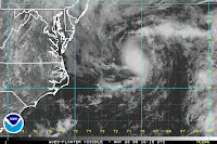 1:00PM: Well, what do you know... THE NHC-TPC, at 11AM, issued a public advisory for Tropical Depression 1, which is the first tropical cyclone in the Atlantic Basin for 2009, and arriving on the scene 5 days ahead of the season.
THE DEPRESSION IS NOT EXPECTED TO THREATEN ANY LAND AREAS. THE DEPRESSION IS FORECAST TO BECOME A TROPICAL STORM OVER THE NEXT DAY OR SO...
Looks like we've got the birth of Tropical Storm Ana. Have a great day!
~Dewdrop
Wednesday, May 27, 2009
Having a wild time!!!
So, onto my summary of Memorial Day... what a day! I gathered up Mini-Dew and her 3 friends and we were off to Wild Adventures, a local amusement and water park. The girls had a great time riding on the various rides, and I followed them around, occasionally riding to fill a spot where one or more didn't want to ride something. The weather started out perfectly, blue skies, fair weather cumulus sparingly scattered amongst the sky,
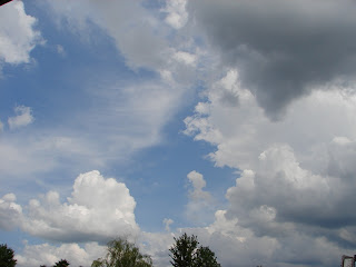


Leaving the park was actually my favorite part of the day... there was some amazing thunderstorm structure on the horizon. The girls really razzed me about stopping 10,000 times along the way home to shoot that... oh well.
In other news, looks like the guys at the SPC have added an area of slight risk for severe weather to parts of Texas, Louisiana, Arkansas, Missouri, Mississippi, Tennessee and a tiny sliver of Illinois. I am sure Vortex2 is all over it!
Have a fab day!
~Dewdrop


