SKYWARN® storm spotters are part of the ranks of citizens who form the Nation's first line of defense against severe weather.
 Well, I missed out on talking about the topic that is near and dear to my heart regarding severe weather. Saturday's topic, and the last in the series covered during Severe Weather Awareness Week in Georgia was Volunteers/Spotters. I am a National Weather Service certified advanced SKYWARN® Spotter. I have trained online through the this link. You can visit the link here to visit the National SKYWARN® site for more information.
 How Can I Get Involved?
... or you can click on the linked map below to find classroom training information for an area near you.
NWS has 122 local Weather Forecast Offices, each with a Warning Coordination Meteorologist, who is responsible for administering the SKYWARN® program in their local area, and may be contacted through this site: http://www.stormready.noaa.gov/contact.htm
[T]he information provided by SKYWARN® spotters, coupled with Doppler radar technology, improved satellite and other data, has enabled NWS to issue more timely and accurate warnings for tornadoes, severe thunderstorms and flash floods.
I like to stay current on my training, by attending any nearby training that I can get to... I have attended 4 training classes in person and I am scheduled to attend another this month. I enjoy the classes because I always learn something new. I like to refresh my knowledge, and I am a total weather geek who likes to get together with other weather geeks and talk weather. What is SKYWARN®?
Certainly, now that you know about it, you are wondering who can do it... right?
To obtain critical weather information, NOAA's National Weather Service (NWS), part of the U.S. Department of Commerce, established SKYWARN® with partner organizations. SKYWARN® is a volunteer program with nearly 290,000 trained severe weather spotters. These volunteers help keep their local communities safe by providing timely and accurate reports of severe weather to the National Weather Service. Although SKYWARN® spotters provide essential information for all types of weather hazards, the main responsibility of a SKYWARN® spotter is to identify and describe severe local storms. Who is Eligible?
I find training and education about severe weather to be an essential element of storm chasing; otherwise, I am doing nothing but endangering myself and others. As a SKYWARN® Spotter, I am able to use my training and knowledge and apply it to what I am seeing and then inform the National Weather Service, so they can issue appropriate warnings to aid in the protection of life and property. I become part of the eyes for the Weather Service. It's an honor to help and serve in that way by attaching knowledge to my passion and use it to benefit others.
NWS encourages anyone with an interest in public service and access to communication, such HAM radio, to join the SKYWARN® program. Volunteers include police and fire personnel, dispatchers, EMS workers, public utility workers and other concerned private citizens. Individuals affiliated with hospitals, schools, churches, nursing homes or who have a responsibility for protecting others are also encouraged to become a spotter.
With severe weather in our midst, including a moderate risk for severe weather tomorrow... sounds like spring is in our midst! Check out the forecast...
Today... Tomorrow (with the moderate risk for severe weather)
20-30 KT LOW LEVEL SHEAR AND LARGE CLOCKWISE CURVED LOW LEVEL HODOGRAPHS WILL FAVOR TORNADOES...SOME STRONG.
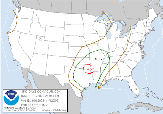 ... and Wednesday (almost includes me!)...
PERHAPS THE RISK FOR TORNADOES...AN APPRECIABLE RISK FOR DAMAGING WIND GUSTS APPEARS TO EXIST WITH AN ANTICIPATED FRONTAL SQUALL LINE WEDNESDAY

Aside from missing the severe weather topic and some severe wind in Texas over the weekend... I had an exciting weekend. My wonderful gtb and his dear daughter as well as Mini-Dew and her father attended a Valentine's Dance for fathers and daughters. I had a ball primping the girls and then doing their prom-like photo shoots for the big night out with their respective daddies. So much fun!
 Then, there was the birthday celebration for my wonderful gtb's dear son. Yummy homemade cake and a couple of games of bowling... I think I figured out where my shoulder problems came from. I bowled all through high school and college. That's right, I beat them... lol.
 Have a great day!!!
~Dewdrop
Monday, February 09, 2009
The first line of defense!


Friday, February 06, 2009
Turn Around Don't Drown™
Well, as you see, much of the country was covered in freezing cold temperatures again this morning, with much of Georgia and Florida dealing with, yet another day of, much colder temperatures than what we are accustomed to...
 What an exceptionally cold winter we have had so far, with too many periods of longer than normal freezing conditions. In fact, on Thursday, some records were broken for low temperatures on that date within the County Warn Area for NWS-Tally. Look at my poor little rain gauge... all covered in frosty twirls. This is not what a rain gauge in south Georgia should look like, but it is pretty indicative of how cold the dew is...
 Fortunately, we are in for a temperature rebound soon. Great googaly moogaly, there is even a small area outlined with a slight risk for severe weather on the day 3 outlook. Way to go, Steve M., TX! Lucky dog.
Speaking of severe weather, it's time for me to discuss the next topic during Georgia's Severe Weather Awareness Week... FLOODING! According to the National Weather Service: Many people do not know this, but flooding kills more people than any other weather hazard.
 Heat is the number one weather-related killer worldwide, but flooding kills more people, here in the United States than any other weather hazard, and is, therefore, a very important topic to be informed about. Sadly, more than half of all those fatalities occur in vehicles. That is why it is so important that if you see flood waters, that you TURN AROUND, DON'T DROWN.
 A mere six inches of fast-moving flood water can knock over an adult. It takes only two feet of rushing water to carry away most vehicles. This includes pickups and SUVs
... and there is no telling how deep it is just looking at it! People have a tendency to underestimate the power and force of moving water.Flash floods are usually caused by slow moving thunderstorms or thunderstorms that move over the same area one after the other. These floods usually occur within 6 hours of heavy rainfall and are usually more life threatening as a result. Areas most prone to floods are mountainous streams and rivers, urban areas, low-lying areas, storm drains, and culverts.
What can you do to protect yourself and your loved ones from Flooding? (Thanks for asking!)
River flooding is caused by the gradual increase in the water level of river or creek. These floods usually occur seasonally with general rains, or with heavy rainfall from tropical systems. A good example of this flooding is the flooding that affected south Georgia after Tropical Storm Alberto in 1994.
1. Know what to listen for.
A Flood Watch or a Flash Flood Watch means that conditions have been detected that could lead to flooding of a certain area. A River Flood Warning or a Flash Flood Warning means that flooding is imminent and you should take action immediately. You can monitor the weather radio or any local radio or TV station to get the latest information.
2. If flooding occurs get to higher ground.
3. Avoid areas already flooding, especially if the water is fast flowing.
Do not attempt to cross flowing streams. Road beds may be washed out due to the flooding. Never try to cross flooded roadways. Turn Around Don't Drown™!!
4. If your vehicle is suddenly caught in rising water, leave it immediately and seek higher ground. Turn Around Don't Drown™!!
5. Be especially cautious at night when it is harder to see flood dangers. Turn Around Don't Drown™!!
6. Turn Around Don't Drown™!!
Yep, that covers it!
Have a great weekend!
~Dewdrop
Thursday, February 05, 2009
Lightning strikes and thunder rolls
 Hey there! Thanks for stopping by for this week's installment of SKY WATCH FRIDAY! Please visit Klaus, Sandy, Ivar, Wren, Louise and Fishing Guy's SKY WATCH BLOG to participate in Sky Watch Fridays, which is WELL WORTH YOUR WHILE!! Thanks to Dot, the momma of this fabulous blogging event, and to my dear friend, Tom, who brought it to full blossom. I, personally, love visiting the skies all over the world!!! You should definitely come fly with us! In honor of Georgia's Severe Weather Awareness topic of the day... Lightning, I thought I would post my favorite lightning capture.
 I took the shot on August 23, 2007, in my backyard, well through the storm door that leads to my backyard. A huge thanks to Mikey for removing the rain drops that were on the glass. Though, heat is actually the number one weather-related killer and flooding a close second, lightning is one of the leading causes of weather-related deaths in the United States. Most lightning deaths occur during summer months in Georgia and mostly while people are caught outdoors during a thunderstorm.
 A single lightning bolt can be as hot as 50,000 degrees Fahrenheit - hotter even than the surface of the sun.
Thunder is actually the sound of the shock wave generated by the rapid heating and cooling of air caused by lightning. Here are some very important safety tips regarding lightning:1. WHEN THUNDER ROARS, GO INDOORS!!!
Lightning should be taken VERY SERIOUSLY.
*** Stay indoors until 30 minutes after you hear the last clap of thunder. ***
2. Lightning will usually strike the highest object in area.
3. Enclosed vehicles are generally safe, if you avoid contact with metal surfaces.
4. If you are in a forest, seek shelter in a low area under a thick growth of small trees.
5. If you are outside, and feel your hair stand on end, this indicates lightning is about to strike. Drop to your knees and roll forward to the balls of your feet. Place your hands on your knees and tuck your head down. DO NOT LIE FLAT ON THE GROUND!
6. If you are boating or swimming, get to land as quickly as possible.
7. If you are inside, don't use a telephone or other electrical equipment unless in an emergency.
8. Do not take a bath or shower during a thunderstorm.
9. Lightning can strike as far as 15 miles away from the actual storm.
Today, south Georgia and much of Florida temperatures are dipping into record breaking territory with temperatures at or below freezing in much of the area, or in my case, where I watched the temperature drop from 20°F to 16°F during the hour I was getting ready this morning. 
 With a hard freeze upon us today and tomorrow, many farmers are working to try to spare their crops from total devastation. It is really cool how that is done,
  they actually irrigate the crop with a heavy coat of water while the temperatures are dropping to allow a thick layer of ice to form, which works to insulate the plants from lower temps. It wouldn't be so bad, but they just dealt with freezing temperatures a couple of weeks ago.
All that said, I want to share this photo with you. I don't know who to give credit for it, but I have heard that there has been a protest, speaking out against the "Global Warming" theory, that the media has been cramming down everyone's throat. One particular Global Warming protest was very well attended... LOL! Thanks, Sis and Meso Mike, both of whom shall remain blogless... I appreciate y'all sharing the shot with me. Too funny!
Have a bright, sunshiny day!
~Dewdrop
Wednesday, February 04, 2009
Preparing for the worst...
 Doggone Arctic Air! I am so tired of winter! I am fed up with the cold! I am sick of not feeling my toes! I am tired of my runny nose! I am tired of layers upon layers of clothes! This is south Georgia! Uh, hello Ma Nature, SOUTH Georgia! It's not supposed to be below freezing for days in a row. We aren't supposed to have a feels like temperatures in Georgia ranging from the teens (here) to as low as negative°. Check out this morning's 9AM readings locally.
 As much as I hate it for myself, at least, I am able to get inside where there is power for heat. My heart just aches for the folks in those central states who have been dealing with the power outages since the ice storm over a week ago. How do you deal with temperatures in the teens or worse when you have no heat? God bless them.
Today is day 4 of Severe Weather Awareness Week in Georgia, and today's topic is Tornadoes! As a storm chaser, I must admit that I have a peculiar obsession with tornadoes. I study them. I find them fascinating. That is not to say that I want them to happen and destroy and kill. That is absolutely FALSE! I do not want them to harm people at all, but as they exist, they fascinate me, and I do hope to get out to the plains this year to witness (at least) one that doesn't harm anyone or anything. Tornadoes are violently rotating columns of air, extending from the thunderstorm that is in contact with the ground. Tornadoes can vary in shape, size and intensity. Most tornadoes are weak, lasting a few minutes and producing winds of less than 100 mph. However, a few tornadoes are strong or even violent. These tornadoes last from 20 minutes to over an hour and can produce winds of between 100 and 300 mph.
In Georgia, we have an average of 6 tornadoes reported annually. Unfortunately, 2008 was a banner year in Georgia as 63 tornadoes actually occurred. 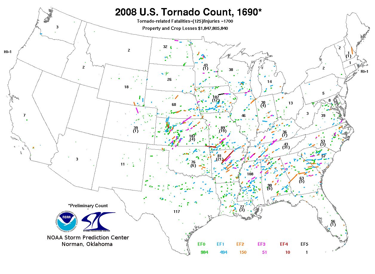 Five lives perished as a result of these tornadoes in Georgia. Tornadoes usually occur from March to May in the mid afternoon to early evening, but they can occur at any time of year during any time of day. Unfortunately and dangerously, here in Georgia, the bulk of our tornadic supercells are heavily precipitated, which makes tornadoes quite obscured and horribly dangerous. 2008 was an exceptional year nationally for tornado incidences. The actual tornado count for 2008 stands at 1690 tornadoes, blowing the 10-year-average of 1270 out of the water.
 All of these fascinating statistics and charts are available at this SPC link.
So, what can you do to protect yourself and your loved ones from these potentially deadly violently rotating columns of air? (Another great question!)1. The best thing to do is to have a plan of action in place before threatening weather develops.
A statewide tornado drill took place this morning, allowing schools and others an opportunity to test their plans and teach others about what to do in the event of a tornado warning. I hope that all schools in Georgia participated in this practice drill.
2. Know the difference between a watch and warning.
(A Tornado Watch means conditions are favorable for tornadoes to develop, but there is not an imminent threat. A Tornado Warning means a tornado has been detected and an imminent threat to life and property has developed. )
3. Know your area so you can track storms, listen to a weather radio, local TV or radio reports. Make sure you have battery backup.
4. Monitor area forecasts to know if threatening weather is possible when you are planning outdoor activities.
5. If a tornado is imminent and you are in a home or building, move to a pre-designated shelter on the lowest floor, such as a basement, or a small interior room closet, bathroom or hallway - and get under a sturdy piece of furniture. Remember to always put as many walls as possible between you and the outside.
6. Stay away from windows.
7. Get out of automobiles!
(Do not try to outrun a tornado in your car. If you are caught outside or in a vehicle lie flat in a nearby ditch or depression, but be aware of possible flooding, and cover your head with your hands. Do NOT go under an overpass!)
8. Mobile homes offer little protection from tornadoes.
(You should leave a mobile home and go the lowest floor of sturdy nearby building or a storm shelter.)
Have a great day!
~Dewdrop
Tuesday, February 03, 2009
What to do when severe weather strikes
 [Photo by audgesshots: link]
Before I get into the severe weather topic of the day, I want to take a minute to discuss the consequences of the ferocious ice storm that wreaked havoc across much of the central and northeastern United States a week ago and is now dropping buckets of snow in England and other parts of Europe. That's right, the same system that has left hundreds of thousands of people without power for heat. Some are looking at another week before power can be restored... some are facing as many as 3 more weeks before they have power again... and another clipper system is working cold temperatures into the area. Even sadder are the lives that have been lost as a result of this horrific winter ice storm event... 55 lives have been taken, which surpasses the 30 lives lost in the North American Ice Storm of 1998. The hardest hit state appears to have been Kentucky, with 24 of those 55 deaths being in Kentucky alone. In Kentucky, 10 of those deaths are from carbon monoxide poisonings (carbon monoxide detectors are as much a must as smoke detectors and NOAA Weather Radios!) and another 9 from hypothermia. It has been horribly devastating! Yes, I realize that it's anticlimactic to go from that story to a discussion about severe weather, especially during a period of severe weatherlessness (aka, SDS, which is a frequently used acronyn in the storm chasing world, which stands for Supercell (or Storm) Deprivation Syndrome.); however, It is vital to learn these safety tips and prepare plans during times of weatherlessness, so you are ready when weather strikes.
  Today's lesson, during Georgia Severe Weather Awareness Week, is on thunderstorms. As a certified advanced SKYWARN Spotter for the National Weather Service, I have spent a great deal of time learning about severe thunderstorms. There are several significant weather occurrences that warrant attention, but here are a couple that you should take notice of...
Severe Local Storm
The presence of these conditions in my area will initiate a call by me to the National Weather Service, so they can be aware of ground conditions and issue the appropriate warnings in an effort to protect life and property. A convective storm that usually covers a relatively small geographic area, or moves in a narrow path, and is sufficiently intense to threaten life and/or property. Examples include severe thunderstorms with large hail, damaging wind, or tornadoes. Although cloud-to-ground lightning is not a criteria for severe local storms, it is acknowledged to be highly dangerous and a leading cause of deaths, injuries, and damage from thunderstorms. A thunderstorm need not be severe to generate frequent cloud-to-ground lightning. Additionally, excessive localized convective rains are not classified as severe storms but often are the product of severe local storms. Such rainfall may result in related phenomena (flash floods) that threaten life and property.
Severe Thunderstorm
A thunderstorm that produces a tornado, winds of at least 58 mph (50 knots), and/or hail at least ¾" in diameter. Structural wind damage may imply the occurrence of a severe thunderstorm. A thunderstorm wind equal to or greater than 40 mph (35 knots) and/or hail of at least ½" is defined as approaching severe.
~source: www.weather.govIn Georgia, the biggest threat from severe thunderstorms is damaging straight line winds and large hail. Straight line winds can reach speeds excess of 100 mph and produce damage similar to a tornado.
Severe weather occurs most often in Georgia in spring and summer months during afternoon hours; however, severe thunderstorms can occur at any time of the day AND during any time of the year! What can and should you do to protect your family??? (great question!!)
~source
1. Have a plan! (Educate yourself before it happens! Know what you'll do when weather strikes!)
2. Know the difference between a watch and a warning (A watch means conditions are favorable for whatever the specified watch is (so watch out!), and a warning is indicative of an imminent threat to life and property, meaning the storm is upon you and it is time to protect yourself and your family from imminent danger.)
3. Know your area, so you can know where the storms are relative to you as you listen to your weather radio, television or local radio.
4. If severe weather is imminent and you are already inside, either get into a basement or an interior room on the first floor.
5. If you are outside, try to get into some sturdy shelter.
Severe weather warnings need to be taken very seriously. Don't forget that Georgia will be initiating a statewide tornado drill at 9:10am tomorrow. Information is available by following this link.
Have a great day!!!
~Dewdrop
Monday, February 02, 2009
It's Groundhog Day!
Happy Groundhog Day! Well, sort of... unfortunately, Punxsutawney Phil once again saw his shadow today predicting 6 more weeks of this agonizingly cold winter weather. In this shot, by Carolyn Kaster/AP...
Poor little groundhog... it seems, he might need to be entered into the forecasters protection program. Six more weeks of winter on a mostly cloudy day... some nerve.  "Ben Hughes, handler of the weather-predicting groundhog Punxsutawney Phil, holds Phil in the air after removing him from his stump at Gobbler's Knob on Groundhog Day, Monday, Feb. 2, 2009, in Punxsutawney, Pa. The Groundhog Club said Phil saw his shadow and predicted six more weeks of winter. (AP Photo/Carolyn Kaster)" ~source
Down here in the south though, we have our own weather-telling rodent that forecasts the arrival of spring. Ours is determined by our very own General Beauregard Lee, located at the Yellow River Game Ranch near Stone Mountain, Georgia. Fortunately for us, we had more overcast skies than in Pennsylvania, and... 7:33AM - GENERAL BEAU LEE DOESN'T SEE SHADOW; PREDICTS EARLY SPRING!
Hooray for us!!!! Sounds like chase season will start early for me... especially with Beauregard's 96% accuracy claim... Lee's every move on February 2nd, Ground Hog Day, because he has an astounding rate of accuracy. Even The National Weather Service has commended General Beau Lee for his predictions. ~source
... but I am coming across lots of contradictory claims. I'll be happy with an "early spring" though. I am tired of the cold!
I do have some exciting Georgia news! This week is Georgia Severe Weather Awareness Week! What an exciting time it is to learn wonderful things about weather safety. Topics to be covered are...
Sunday - Family Preparedness
Monday - NOAA Weather Radio
Tuesday - Thunderstorm Safety
Wednesday - Tornado Safety (Tornado Drill)
Thursday - Lightning Safety
Friday - Flooding
Saturday - Volunteers/Spotters
I plan to cover these topics each day to support the National Weather Service in their education. It's a cause I support whole-heartedly (...as if you couldn't tell)! I missed Sunday's topic while I was enjoying company for the Superbowl and a little Superbowl pre-party. Don't overlook the HIGHLIGHT OF THE WEEK!The statewide tornado drill on Wednesday - February 4
last year, it was actually rescheduled for severe weather...
A test Tornado Warning will be issued around 9:10 am on NOAA Weather Radio
For additional information concerning the tornado drill, please view this invitation.
Back-up date for Tornado Drill (if Severe Weather is imminent on Wednesday will be Friday the 6th.)
Anyways, Sunday's topic was Family Preparedness! 1. Gather information about hazards.
More information is available at this link. Mini-Dew and I have a definite plan for severe weather, and I sleep with a weather radio beside my bed.
2. Meet with your family to create a plan.
3. Implement your plan.
4. Practice and maintain your plan. Great lead in, Dew... Today's topic is the NOAA Weather Radio! The NOAA Weather Radio is as important as a life-saving device as a smoke detector in a home or business and a life-preserver near water. EVERY home should be equipped with at least one NOAA Weather Radio with battery backup.
 NOAA weather radio is a nationwide network of radio stations broadcasting continuous weather information direct from a nearby National Weather Service office. NOAA weather radio broadcasts National Weather Service watches, warnings, forecasts, and other hazard information 24 hours a day.
I have a radio that sounds an EAS signal (which will wake the dead, trust me) for the SAME code counties I have selected. I have chosen surrounding counties, so I can be aware of what's coming and be prepared by waking up to see what's coming my way. If it's really bad, I can alert a fellow Weather Brigade team member to keep eyes on my area in case I lose power. If you don't have a weather radio in your home, drop what you're doing, go out and buy one, NOW! It's that important! Many vendors carry NOAA Weather Radios!
Some weather radios are equipped with a special tone feature, which can sound an alert and give you immediate information about a life threatening situation. During an emergency, the National Weather Service will interrupt routine weather radio programming and send out a special tone that activates weather radios in the warning area. Recently, a radio that can handle the Emergency Alert Signal was introduced. The Specific Area Message Encoder (SAME) tone alert can be set up to only sound for your county. This cuts down on the number of unwanted tones you receive, and alerts you only when a life threatening situation is in your county.
Have a great and weather-wise day!
~Dewdrop