Yesterday, I did something very exciting. I participated in the first National Weather Service - Tallahassee online spotter training session. Yes, I realize that I have been through online training, and I have sat through 6 or 7 live spotter training classes. I have covered both beginner and advanced level training, inside and out. I have traveled near and far, chasing an unquenchable thirst for more knowledge. This was a live webinar though. I didn't have to go anywhere.
  Please click on the link above to see about becoming a SKYWARN® Spotter. I strongly encourage it, even if you're not as coo-coo for weather as I am. As Mini-Dew has told me time and time again, I'm "a nerd". I know that. I accept that. I could probably teach the spotter classes at this point, but I love sitting through the classes. I have earned yet another certificate of training as a SKYWARN® Spotter, this time in my new name, by taking a test at this link. Fortunately, I knew better than to say that the most common storm type in our area is the Common Southeastern Frog-strangler... though they do occur... LOL!! Laugh as you may, I always walk away from those training sessions with new information, and this one was no different. I learned more about RFD (rear flank downdraft) and the implications of possible tornadic activity, and I had only a limited knowledge of those before. I learned about the implications of pileus clouds, which I actually could have figured out, but hadn't thought about it.
 Pileus clouds are the fibrous lid over cumulus congestus clouds caused by heavy upper level shear. I don't have any great pics of pileus clouds, but I hope to soon. This is more of a dissipating storm.
I found the wind rating chart to be an effective resource tool, and it was especially jazzed up with the capture by my friend, Mike Umscheid.  Then there was the other pic shared that was taken by one of my other friends to the wall cloud section. I'm not sure which Steve Miller captured this shot, but it was cool to see it taken by one of my friends.
 I really need to start being more assertive in submitting my own pics to the NWS for possible inclusion in their training slideshow. They say they want my stuff.
  I should start sending my stuff in, huh? Then, I could get all excited when I see my stuff...
Have a spotterific day!
~Dewdrop
Wednesday, October 21, 2009
More SKYWARN® Spotter training


Tuesday, February 17, 2009
Severe weather... finally, a cure for SDS!
Looks like a break in the monotonous cold/warm up/cold/warm up cycle is in store for my neck of the woods. The SPC has for today dumped a slight risk for severe weather that almost includes Alabama Mike.  It looks like the bulk of it is capped and instability will be limited by some low clouds that have set up there, but tonight in the east northeast area of the slight risk, they are expecting more action with...
SLIGHTLY ELEVATED ROTATING STRUCTURES AND BOWS WILL POSE A THREAT FOR SVR HAIL...AND...ESPECIALLY TOWARD 12Z...POSSIBLY DMGG WIND.
I hate night events. Hate them.
The exciting part of the forecast arrives on Wednesday... I think that for the first time since last year, I am solidly within the slight risk area.
 Here's what they are saying...
 THE STORMS WILL SHIFT EAST DURING THE DAY (toward me)...BUT IN THEIR WAKE...WIDESPREAD CLOUDS WILL LIKELY PERSIST OVER MUCH OF WARM SECTOR (here) WHICH WILL TEND TO LIMIT INSTABILITY (can't go severe without instability). (HOWEVER...) VEERING OF THE LOW LEVEL FLOW TO WLY DURING THE DAY MAY HELP TO MIX OUT THE LOW CLOUDS FROM THE WEST JUST AHEAD OF THE FRONT (if this happens far enough ahead, enough daytime heating will occur that will offer the instability we need for some action).
 With the right convective set-up, things could very possibly explode (storm-wise) right over my head... which would actually be bad because it would be that "out of nowhere" scenario, which is one of the the worst for preparing non-weather geeks. They "didn't see it coming", so to speak.
 ACTIVITY WILL BE EMBEDDED WITHIN VERY STRONG KINEMATIC PROFILES WHICH WOULD SUPPORT AN ORGANIZED SEVERE THREAT INCLUDING SUPERCELLS AND BOWING STRUCTURES WITH ANY SURFACE BASED DEEP CONVECTION.
If not for the limiting factors and uncertainties discussed, probabilities would be much higher, as everything else supports a big event. Basically, for such an event, clouds would have to break up just ahead and moisture would have to move in... all at just the right time... but, it could happen. Here's the catch... I have SKYWARN® spotter training scheduled tomorrow. I joked with the Emergency Manager who scheduled the training that it was nice of him to schedule severe weather for our training. He joked that he just wanted to "be a hands on class". LOL! That would be awesome if we could do some on-the-job training for our spotter class! Click on the SKYWARN® logo to link to information about spotter training in your area. I think everyone stands to benefit from spotter training. Even if you don't plan to call into the National Weather Service, you will be better educated about the weather around you and, therefore, better prepared for what may come, to more adequately prepare for inclement circumstances. Did I mention that I attended "Chase School" (thanks, Alabama Mike for pointing that out), I have found and am fulfilling my destiny. When it comes to storms, you can never know too much! Thanks to all my training, I've graduated from this...
  ... to this...
Updated outlook: A CLUSTER OF STORMS COULD EVOLVE WITH THIS FORCING ACROSS NORTHERN/CENTRAL ALABAMA THROUGH CENTRAL/SOUTHERN GEORGIA DURING THE MID TO LATE AFTERNOON INTO EVENING HOURS. WHILE THE RISK FOR DAMAGING WINDS/HAIL MAY BECOME THE MOST PROMINENT SEVERE THREATS...SIZABLE CLOCKWISE CURVED LOW-LEVEL HODOGRAPHS MAY BE SUPPORTIVE OF TORNADO POTENTIAL WITH THE INITIAL MORE DISCRETE STORMS.
Holy guacamole...
Have a great day!
~Dewdrop
Monday, February 09, 2009
The first line of defense!
SKYWARN® storm spotters are part of the ranks of citizens who form the Nation's first line of defense against severe weather.
 Well, I missed out on talking about the topic that is near and dear to my heart regarding severe weather. Saturday's topic, and the last in the series covered during Severe Weather Awareness Week in Georgia was Volunteers/Spotters. I am a National Weather Service certified advanced SKYWARN® Spotter. I have trained online through the this link. You can visit the link here to visit the National SKYWARN® site for more information.
 How Can I Get Involved?
... or you can click on the linked map below to find classroom training information for an area near you.
NWS has 122 local Weather Forecast Offices, each with a Warning Coordination Meteorologist, who is responsible for administering the SKYWARN® program in their local area, and may be contacted through this site: http://www.stormready.noaa.gov/contact.htm
[T]he information provided by SKYWARN® spotters, coupled with Doppler radar technology, improved satellite and other data, has enabled NWS to issue more timely and accurate warnings for tornadoes, severe thunderstorms and flash floods.
I like to stay current on my training, by attending any nearby training that I can get to... I have attended 4 training classes in person and I am scheduled to attend another this month. I enjoy the classes because I always learn something new. I like to refresh my knowledge, and I am a total weather geek who likes to get together with other weather geeks and talk weather. What is SKYWARN®?
Certainly, now that you know about it, you are wondering who can do it... right?
To obtain critical weather information, NOAA's National Weather Service (NWS), part of the U.S. Department of Commerce, established SKYWARN® with partner organizations. SKYWARN® is a volunteer program with nearly 290,000 trained severe weather spotters. These volunteers help keep their local communities safe by providing timely and accurate reports of severe weather to the National Weather Service. Although SKYWARN® spotters provide essential information for all types of weather hazards, the main responsibility of a SKYWARN® spotter is to identify and describe severe local storms. Who is Eligible?
I find training and education about severe weather to be an essential element of storm chasing; otherwise, I am doing nothing but endangering myself and others. As a SKYWARN® Spotter, I am able to use my training and knowledge and apply it to what I am seeing and then inform the National Weather Service, so they can issue appropriate warnings to aid in the protection of life and property. I become part of the eyes for the Weather Service. It's an honor to help and serve in that way by attaching knowledge to my passion and use it to benefit others.
NWS encourages anyone with an interest in public service and access to communication, such HAM radio, to join the SKYWARN® program. Volunteers include police and fire personnel, dispatchers, EMS workers, public utility workers and other concerned private citizens. Individuals affiliated with hospitals, schools, churches, nursing homes or who have a responsibility for protecting others are also encouraged to become a spotter.
With severe weather in our midst, including a moderate risk for severe weather tomorrow... sounds like spring is in our midst! Check out the forecast...
Today... Tomorrow (with the moderate risk for severe weather)
20-30 KT LOW LEVEL SHEAR AND LARGE CLOCKWISE CURVED LOW LEVEL HODOGRAPHS WILL FAVOR TORNADOES...SOME STRONG.
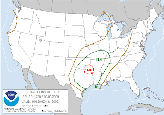 ... and Wednesday (almost includes me!)...
PERHAPS THE RISK FOR TORNADOES...AN APPRECIABLE RISK FOR DAMAGING WIND GUSTS APPEARS TO EXIST WITH AN ANTICIPATED FRONTAL SQUALL LINE WEDNESDAY

Aside from missing the severe weather topic and some severe wind in Texas over the weekend... I had an exciting weekend. My wonderful gtb and his dear daughter as well as Mini-Dew and her father attended a Valentine's Dance for fathers and daughters. I had a ball primping the girls and then doing their prom-like photo shoots for the big night out with their respective daddies. So much fun!
 Then, there was the birthday celebration for my wonderful gtb's dear son. Yummy homemade cake and a couple of games of bowling... I think I figured out where my shoulder problems came from. I bowled all through high school and college. That's right, I beat them... lol.
 Have a great day!!!
~Dewdrop
Thursday, May 01, 2008
Moderate risk and the importance of SKYWARN spotting

DOWNTOWN SUFFOLK VA *** 200 INJ *** TORNADO INITIALLY TOUCHED DOWN AROUND 405 PM...WITH DAMAGE FIRST NOTED ABOUT 2 MILES NORTHEAST OF LUMMIS. THE TORNADO HAD A PATH LENGTH OF ABOUT 10 MILE
 Today, we are facing yet another moderate risk for severe weather, with a 10% probability of tornadoes occurring within that moderate risk area, which covers eastern Kansas, western Missouri, and the southeastern tip of Nebraska.
  Unfortunately, at best it will start firing during evening hours. The forecast calls for an overnight event. I HATE night-time events! They are so much more dangerous because people aren't as aware of what's happening around them. They aren't watching television to get the emergency broadcast messages. They aren't listening to the radio. It is these situations that make weather radios so critical. I really think that life and safety code should be revised to include weather radios built into every home, just like smoke detectors. I think they are as important, and would be a valuable tool for disseminating information to people about every type of emergency... oops, soap boxing again. Anyways, things should be firing up tonight in the central plains. May is statistically the month for the most occurrences of tornadoes, with June following in behind that. People in the area of moderate risk for severe weather should be vigilant... and have their weather radios ready!
 Now, yesterday, I spoke to the issue of the ridiculous overabundance of "home videos" of large and destructive tornadoes heading toward the untrained videographers. Thank God, with all the morons (sorry, my opinion... perhaps you prefer yahoos as Ken referred to them...) out there trying to capture video footage of a very dangerous storm that they knew very little about, there were still no reported fatalities, but it could have been quite different. I am, by no means, elite in my weather knowledge. There is a large group of meteorologists and cool weather geeks out there with even more weather knowledge that I have. I am encouraging everyone out there to expand your climatological horizons and learn more about what is going on around you. One way of doing this is to become a trained SKYWARN Spotter. SKYWARN Spotters are the eyes in the field of the National Weather Service.
  Spotters fill in the holes that limitations of radar leave, being able to offer eye witness accounts of actual, real-time weather activity, which gives the meteorologists a better understanding of the conditions to offer better opportunities for warnings in an effort to protect life and property. The National Weather Service offers training through its local Weather Service offices. Click on the map to link to contact information for your area. There is both basic and advanced SKYWARN Spotter training available. David Drummond has put together a great comprehensive site for anyone interested in learning about becoming a spotter or just expanding their weatherwiseness. I encourage everyone to take at least a basic course in spotting which is available online through many local Weather Service websites. For example, you can access Tallahassee's online training by clicking this link.
 Important note - This spotter training course is intended for volunteers within the NWS Tallahassee's area of responsibility. Each NWS Forecast Office designs and administers the Skywarn Spotter program to best serve their area. Please contact your local NWS Forecast office to become part of Skywarn in your area.
Have a bright, bright, bright sunshiny day!
~Dewdrop
Friday, February 08, 2008
Consider becoming a Skywarn Spotter, help save lives when disaster strikes

 I was doing some exploration on the SPC website, and I came across this Annual Reports Summary. Of course, this week's severe weather outbreak really skewed the graphical results, but it is amazing to me to see the impact depicted in that way.
I was just looking at some pictures of the tornado damage again, specifically I was on the CNN picture site for the tornado outbreak, and I was struck by some of the Oxford, MS, pictures.  Looking at those pictures and knowing that no deaths were reported is amazing. The amount of death, damage and destruction caused by these tornadoes is horrific. I am so glad that there are warning systems in place to help protect lives and property. The SPC, local NWS offices and a network of trained storm spotters and knowledgable storm chasers undoubtedly saved countless lives.
  If you have any interest at all in becoming a part of that warning system, I encourage you to contact you local National Weather Service Office about becoming a trained Skywarn Spotter. Click on the map here, and on the NWS site map, click on your location within the United States, and it will take you to that local office's site. Somewhere on that site (look in the left sidebar), there should be information about how to get trained in your area (some areas offer online spotter training), but you can click on the Skywarn logo here for a link to more information. Your training can help save lives! YOU can make a difference!
 That said, I would like to share with you my sunset yesterday. I was trapped at work finishing up, but I took a minute to capture this spectacular sight. Here are a few shots. Enjoy, and happy Friday!
 Ciao,
Ciao,
~Dewdrop