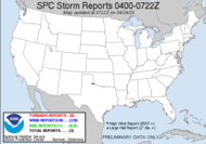
 Today is, of course looking like a nothing event... we should have rain as we did overnight, few rumbles of thunder as time prgresses today, but I am not looking for much to occur. Incidentally, the severe weather drills throughout the state have been rescheduled on account of inclement weather... that's irony for you. The big event... the one that could be the one to kick off our severe weather season is the VIGOROUS UPPER-LEVEL TROUGH AND CLOSED-OFF LOW. DYNAMICS AND VERTICAL SHEAR WITH THIS SYSTEM WILL BE VERY STRONG WHICH COUPLED WITH ADEQUATE LOW-LEVEL MOISTURE SHOULD RESULT IN A WIDESPREAD SEVERE WEATHER EVENT A MUCH STRONGER LOW WILL APPROACH FROM THE NW ON SUNDAY... WITH A ROUND OF SHOWERS AND STORMS OUT AHEAD OF ITS COLD FRONT POSSIBLE ON SUNDAY AND INTO MONDAY MORNING. ALTHOUGH WEAKENING OF THE SQUALL-LINE MAY OCCUR LATE SATURDAY NIGHT OR IN THE MORNING ON SUNDAY... REGENERATION OF THE LINE SHOULD OCCUR BY SUNDAY AFTERNOON. A SEVERE THREAT MAY ALSO DEVELOP IN NRN AND CNTRL FL MONDAY WITH THE THREAT AREA SHIFTING SWD ACROSS FL ON TUESDAY. The question now appears to be timing. I am disturbed by the current forecasted timing for our area, putting it in possibly Sunday night. I've already shared my feelings regarding night events, but a Sunday afternoon/evening event would be OK with me. I could actually chase that... Exciting stuff to watch, anyway. The plains should see major storms on Saturday.
Went to pre-op with Hubby today, and they ran all the important tests for surgery, took all the lab work, pictures, and readings. Surgery is Tuesday at 0700, first on the list. He'll be staying overnight at a minimum.
I'd better get.
Toodaloo,
~Dewdrop
Wednesday, February 21, 2007
Maybe... but when...?
Subscribe to:
Post Comments (Atom)


No comments:
Post a Comment
Dew comment, please...