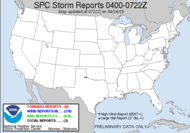
Ok... so now things are a little more active..., and it sounds like things might get interesting... this in out of the SPC: ..FL/GA/SC... BROKEN LINE OF SHOWERS AND THUNDERSTORMS EXTENDS FROM EXTREME WESTERN GA INTO SOUTHEAST AL. THIS ACTIVITY IS CURRENTLY IN REGION OF SURFACE DEWPOINTS ONLY AROUND 55F...WITH STABLE SURFACE CONDITIONS. MODELS FORECAST THAT MOISTURE WILL INCREASE RATHER RAPIDLY AHEAD OF FRONT TODAY ACROSS PARTS OF FL/GA/SC WITH CONVECTIVE INTENSIFICATION LIKELY BY EARLY AFTERNOON. LOW LEVEL WINDS WILL BE MORE VEERED THAN YESTERDAY...BUT SUFFICIENT DEEP LAYER AND LOW LEVEL VERTICAL SHEAR WILL REMAIN FOR A RISK OF SUPERCELLS CAPABLE OF DAMAGING WINDS...HAIL...AND ISOLATED TORNADOES. THIS ACTIVITY WILL LIKELY MOVE OFF THE FL-SC ATLANTIC COAST BY EARLY EVENING. Early afternoon... during church then... fab. Yep, things are looking much more interesting. TLH is still down. They have a temporary page up... perfect timing...
More updates to come...
Update 0950: Wind is really picking up outside. I can hear it pounding against my house. Looking like everything will come to a head during the early afternoon hours. I am counting on a slight delay, so I can get from church to a good position in time. We shall see...
~Dewdrop
Sunday, February 25, 2007
Very Interesting...
Subscribe to:
Post Comments (Atom)


No comments:
Post a Comment
Dew comment, please...