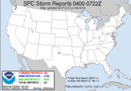
Reports coming in out of Alabama are tragic. It appears that an unbelievable number of tornadoes ravaged that state, almost as if a bullseye over Alabama marked it for death and destruction. It's humbling. The SPC was right to offer a high risk for today. Definitely a bad day for many folks. The truly dark side of storms has revealed itself in a frightening way. My thoughts and prayers are with all those trying to pick up the pieces, as this storm continues to make its way across the southern states. I have seen some pictures now, read some reports. It's a horrific scene. I feel blessed that we were spared.
Trends now, seem to have it tracking to my north as it moves across. I don't expect anything, but, of course, I will keep an eye on the GR and an ear on the weather radio, as the potential still exists (we are still in a moderate risk status from the SPC there is some talk of a secondary wave and some convective convergence -- I am not seeing it, but who am I?). Stay safe all you chasers who decide to go out... This storm is intense. I don't do night chases... so I'll be watching from my office...
10:00 Update: System becoming linear. Looks like we'll get a piece of it. Something anyway.
11:00 Update: Tornado in Americus, GA, hit a hospital causing two fatalities... there is a fear that the death toll will rise as the night rolls on. My heartfelt prayers go out to everyone impacted.
Here, the wind is picking up. 12 mph winds recorded, and I can hear it beating against the house. The lights are flickering. I hope I don't lose power... hard to chase online that way...
No chase for me...
~Dewdrop
Thursday, March 01, 2007
Sad day in Alabama....
Subscribe to:
Post Comments (Atom)


Look at Mesoscale Discussion #0246....look at the hatched area, that's us.
ReplyDelete23Z MESOANALYSIS INDICATED PACIFIC COLD FRONT /DELINEATING WRN EDGE OF SYNOPTIC SYSTEM WARM SECTOR/FROM MSL SWWD TO PIB. EFFECTIVE...COMPOSITE OUTFLOW BOUNDARY HAS BECOME ESTABLISHED TODAY IN MORE OF AN W-E FASHION FROM INTERSECTION WITH PACIFIC FRONT NE OF MEI ESEWD THROUGH MGM TO NEAR CSG TO AYS. AIR MASS ALONG AND S OF THIS BOUNDARY REMAINS SLIGHTLY TO MODERATELY UNSTABLE /MLCAPES OF 500-1000 J PER KG/ OWING TO DEWPOINTS IN THE MID/UPPER 60S AND TEMPERATURES IN THE LOW/MID 70S. TO THE N OF THIS BAROCLINIC ZONE...PERSISTENT AND MORE WIDESPREAD CONVECTION HAS LIMITED HEATING AND RESULTANT DESTABILIZATION WITH TEMPERATURES COMMONLY IN THE 60S.
ReplyDeleteBROAD ZONE OF LOW-LEVEL WAA IN ADVANCE OF PACIFIC FRONT AND ASSOCIATED UPPER TROUGH WILL LIKELY MAINTAIN CLUSTERS OF TSTMS WITHIN THIS ZONE OF STRONGER INSTABILITY TO THE S OF COMPOSITE OUTFLOW BOUNDARY. REGIONAL VWPS INDICATE VERTICAL SHEAR QUITE FAVORABLE FOR SUPERCELLS CAPABLE OF TORNADOES WITH 0-1 KM SRH OF 300-400 M2/S2 AND EFFECTIVE BULK SHEARS OF 55-70 KT.
Yes, Yes, good shear, good potential energy... The radar trends though... I see potential for perhaps something off the Gulf... but I'm not feeling it.
Thanks, Jay.
~Dew