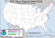
 Yeah, thanks guys... just rub it in, why don't you??? I figured I'd start with the injustice of it all... I patiently wait for almost a year, training, learning, taking in all that I can with regard to severe weather and storm chasing, and then finally, what appears to be the best storm of the season (in my neck of the woods - OK, slightly to my west, but close enough to chase), on the day that I am leaving town. Local chasers are getting all riled up for the big event, and I am going to totally miss it. At least, up in ATL, there is a slight risk, so perhaps I'll get a piece of it... but doggone! The ridge in place now is going to be weakening today, to get the stage set for (grumble, grumble) Saturday's AL/GA event, as the trough that is about to "dig" (love that word, Ron) into the southern plains moves this way. Different models are offering different time frames, but look for it tomorrow... says, Ms. Meteorologist. lol For now, most of the CWA is in a moderate risk category for tomorrow... and where will I be... ATL. sigh. Not looking like a highly unstable environment, but the shear looks impressive at 60kt... and the 850 jet is smoking. Ron describes it as: A SQUALL LINE/BOW ECHO TYPE FEATURE SHOULD PUSH THROUGH THE REGION STARTING LATE AFTERNOON BUT MAINLY THE LATE EVENING HOURS SATURDAY THRU EARLY SUN MORNING. THIS WILL LEAD TO A SETUP FOR POSSIBLE SEVERE WEATHER EVENT WITH DAMAGING WINDS/DOWNBURSTS AND ISOLD TORNADOES MAIN CONCERN. ... and I will be gone... of course...
The big story is today's southern plains event. Chasers are getting in position/if they aren't already for what is expected to be a signiifcant weather outbreak. A Public Severe Weather Outlook has been issued for that area by the SPC. Texarkana is listed with a moderate risk category for severe weather. All the key elements are in place for an elevated risk for strong tornadoes. It's all coming together, low level moisture, vertical shear, LLJ ahead of the warm sector and associated low. Even the dry boundary will likely subside to this beast and moderate instability will take hold. Tornadic supercells... excellent cure for SDS. I hope all the chasers in pursuit of this whopper will use caution and stay safe. I can't wait to see the grabs.
After all this rolls through, it sets up a low in the Atlantic, which will translate to a Nor'Easter for the New England area. Watch out, Dad! Gotta love this weather, huh?
I'll update if anything excites me... looks likely.
Toodaloo,
~Dewdrop
Friday, April 13, 2007
HIGHLY AMPLIFIED/PROGRESSIVE PATTERN EXPECTED THRU WEEKEND
Subscribe to:
Post Comments (Atom)


No comments:
Post a Comment
Dew comment, please...