 As it turns out, we got nothing. I know I've already mentioned that, but I am truly bothered by it. It takes things to that next level of dryness... and raises the fire danger drastically. We are currently under a red flag warning, the (according to the guys) "proverbial slam dunk for red flag conditions". The smoke is expected to creep its way back into this area today, as conditions between the surface low and the ridge have generated strong, gusty winds... Should've expected that... my hair actually turned out nice today (except for the purple, which at this point has dimmed enough to just look like some plum color on the tips. Generally, it looks like a bad dye job, which technically, it was.) As Jeff mentions in the local AFD:
THIS WILL BE A RATHER STAGNANT WEATHER PATTERN FOR THE SOUTHEAST U.S. THIS WEEK. MUCH DRIER AIR SEEN ON WATER VAPOR IMAGERY AND LOCAL SOUNDING (PWAT 0.45") COMBINED WITH THE GUSTY WINDS WILL EXACERBATE THE ALREADY VERY HIGH FIRE DANGER CONDITIONS ACROSS MUCH OF THE REGION.
For the long term, there is a large and interesting low off the coast of the Carolinas developing right now... as it fills and the low over the plains weakens (weakens a lot) and migrates our way, this cool air from the back door front (you know, the one that didn't even have the decency to drop any rain on us)should combine with it to generate some instability during our afternoons, allowing mesocale boundaries, which in turn will create the typical afternoon showers and thunderstorms that we are accustomed to in this region. Of course, it's not forceast to generate drought busters, but at least it will offer some relief from the dry pattern we've been experiencing, and with those doggone fires still burning, hopefully, the rain will help with those, and the lightning will not trigger any additional fires like it did yesterday.
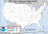
There is still a slight risk area outlined in the plains for the next three days, but things appear to be settling down some. I would imagine that chasers are just plain exhausted from all the action they have seen over the past few days. It has been an impressively strong start to the plains chase season. Everyone out there has caught a nice sampling. I hope they save some for me. I would be completely bummed if I made it out there for my chance of a lifetime and there was nothing. I realize the possibilty of that. I am realistic about the possibility, but how sad that would be...
I'd better run.
Have a great day!!
~Dewdrop


Man, unbelievable luck down there. I'm afraid of that big stacked low retrograding and increasing the winds. It might not get close enough to offer much hope as the western sides of these things are notorious for lots of subsidence. At least there are some signs of a pattern change next week. Your pattern has GOT to break sooner or later.
ReplyDeleteStay positve, Dew!!
ReplyDeleteMaybe this backwards-tracking low will help you all out with the rain...hope so...
ReplyDeleteSteve, We already have the gusty winds, and we have moronic arsonists generating new fires in the area. So, the western sides of these lows are strongly capped? Great... The pattern has GOT to change.
ReplyDeleteJess, trying...
Mike, absolutely hope so.
The Rick Curse has got to go...I am currently doing research to find out when it started and what I might can do to change it before it is too late. ;-)
ReplyDeleteI think we should package you and ship you to a very wet climate... say the rain forest, and then, perhaps we stand a chance.
ReplyDeleteDew, I'm not sure the rain forest would take Rick but it's worth a shot! Heehee Love ya, Rick.
ReplyDeleteYou're probably right, Dawn... ROTF...
ReplyDeleteMan, sending rick to the rainforest would not be very environmentally friendly. Don't they have enough problems with deforestation? LOL!! Sorry Rick...couldn't resist the Bash-Rick-Bandwagon. :-)
ReplyDeleteI am mesmerized by that big upper/surface low. I get dizzy just watching it on satellite loop. I'm glad I'm sitting down. There is alot of talk about this already in subtropical status and taking on tropical characteristics. Is that totally insance or what? It certainly looks like a bonafied tropical system to me. Will they name it?
I do see the NAM breaking out some decent precip down there in ya'lls neck of the woods though. Keep your fingers crossed! (and don't ship Rick to the plains until July...LOL!!)
You're right, Steve. It would be an environmentally unfriendly.
ReplyDeleteI thinking, TS Dew... what y'all think...?
I am liking the NAM... anything that suggests precip here, is OK in my book. If NAM trumps Rick, we'll be all right.
Sheesh people!!! Not feeling the love right about now!!....You are all so jealous of the Rickster! Yes i said it...Jealous!!..Now if I can figure out what, I will let you know. (sticking toungue out in a smarty pants type fashion)
ReplyDeleteIm to sexy for my storm , to sexy for my storm....(sing along now!)
;-P ;-)
Let's say it all together.... ahhh, poor Rick...
ReplyDeleteOk..Where are all my accusers
ReplyDelete?? Yes..I win!!!
It's like watching the last kid getting picked for a game. Heehee
ReplyDeleteOOOoooo... Now that was brutal...Brrrrrr.. The Ice Queen cometh.. ;-P
ReplyDeleteY'all, I think Rick is getting a complex. Awww....
ReplyDeleteWe love you, Rick. Just don't mess up this rain for us, ok?
ReplyDeleteHere's a weather question. Why is it a sub tropical storm instead of a tropical storm? Because of where it started?
Dawn, Unlike a tropical cyclone, this is a cold-core system, and its strongest winds are found miles away from the center of circulation; not tightly wrapped around the center. A tropical cyclone has a warm center and, in fact, derives it's strength from the warm waters it develops over... among other things. The cold-core is a product of where and when it started. Great question! ~Dew
ReplyDelete