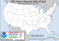
 Incredible start to the official chase season in the plains. This weekend has been quite an active one for the folks out that way. Chasers could take their pick of which ones they wanted yesterday, as yesterday saw 91 reports of tornadoes, including double wedge, multi-vortex, and rain wrapped tornadoes. A total of 15 injuries have been reported (all in Kansas), and there have been several damage reports. Feel free to click on the map to get the full report. It was a very active day, indeed. Another moderate risk outlined for today for the plains with another 15% for tornadoes out that way. A public severe weather outlook has been issued by the SPC. Those chasers are staying busy this weekend.
Thanks to Alabama Mike for posting this link to some humbling shots of Greensburg, KS. Total devastation of that little town. It's amazing to me that the death toll wasn't even higher in light of what you see in those pics. Thank God it was not. Thanks for that link, Mike. Today, I find myself just barely (but I'll take it) in a slight risk category for severe weather. The back door front that they have been forecasting is to come into play for us today, hopefully bringing some much needed rain. We didn't get any yesterday or Friday, so here we are on Sunday, our last chance at some desperately needed precipitation for a while. The SPC also puts us in a 2% risk for tornadoes (just barely again). Could I have a chase opportunity today? I wish I felt more rested... nothing a little severe weather action won't wake right up. Here's what the guys are saying THE BEST CHANCES FOR ORGANIZED CONVECTION WILL BE SEEN IN THE EASTERN PORTIONS OF THE AREA (SOUTH-CENTRAL GA AND THE FLORIDA BIG BEND) AN ISOLATED STRONG TO SEVERE STORM CAN NOT BE RULED OUT...ESPECIALLY ACROSS EASTERN PORTIONS OF THE AREA WHERE THE BETTER SYNOPTIC LIFT IS PRESENT. That's me, folks. Sounds like it's almost showtime... finally!
I'd better get myself ready for church. I'm dragging today. I haven't fully recovered from my all night event. 6:15 Update: It has totally missed us. Some great action to our south, but nothing in my neck of the woods. We got nothing, not one drop of much needed rain. Can you believe that?! We needed it so badly, too. It's unreal.
Happy Sunday!
~Dewdrop
Sunday, May 06, 2007
Storms still cooking in the plains, and now, my turn?
Subscribe to:
Post Comments (Atom)


Unfortunately it looks like the frontal boundary has already moved through southern GA attm. I see your obs in VAL have northeasterly winds now and a lower DP. I know how bad you all need the rain too.
ReplyDeleteSorry to see. You all will have to watch those fires now as the gale center off the southeast to crank the winds up next few days. Not good for active fires in such a dry landscape.
Sitting here mobile awaiting the developing MCS near Orlando
Totally missed us. Is that crazy?! We heard some thunder in the early afternoon, but not a drop of rain. It totally missed us and exploded to our south... so unfair. Be safe chasing. Looks like it's your turn.
ReplyDeleteThanks for the mention and the link Dew!
ReplyDeleteThis really sucks! (Pardon my french)...Sheeesh...Wasted afternoon. Always next time.
ReplyDeleteMy pleasure, Mike...
ReplyDeleteAnd Rick, doggone you for scaring away my storms... We really needed that rain.
storms are just not happening for y'all this year...
ReplyDeleteIt's crazy... we got lightning and no rain... That is totally backwards from what I ordered! Of course the lightning sparked more fires, and the lack of rain was certainly no help at all.
ReplyDeleteWell, now the depoints are dropping. This morning the dewpoint in Anniston, AL was 29. Definitely not good news for fire potential.
ReplyDeleteThat and the ferocious wind gusts we've got are a terribly dangerous combination.
ReplyDelete