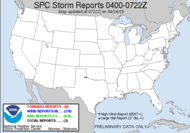
Today, the SPC still has a "see text" section right on top of me:
SOUTHEAST... EXTREMELY UNSTABLE AIR MASS SHOULD DEVELOP AHEAD OF SLOW MOVING...BACK-DOOR COLD FRONT SHIFTING SWD ACROSS ERN NC/SC TODAY. WRN END OF INTENSE THUNDERSTORM COMPLEX EARLY THIS MORNING JUST OFF THE SC COAST MAY SHIFT INLAND DURING THE MORNING...ALTHOUGH MAJORITY OF ACTIVITY SHOULD REMAIN OFFSHORE. NUMEROUS STORMS SHOULD INTENSIFY ALONG AND AHEAD OF THE FRONT FROM FAR SERN NC INTO SRN GA/FL PANHANDLE BY THE EARLY/MID AFTERNOON...BUT OVERALL STORM-SCALE ORGANIZATION SHOULD REMAIN LIMITED UNDER FEEBLE DEEP LAYER SHEAR. HOWEVER GIVEN AMOUNT OF INSTABILITY...IS0LATED HAIL/DAMAGING WINDS CAN BE EXPECTED WITH THE STRONGER CORES.It is currently offshore, really firing up. I guess today will be hit and miss. I will have Mini-Dew all day, so unless it's on top of me, I probably won't get a chance to see anything. They have extended the heat advisory for yet another day... more hot temps, and I noticed more down the line for us... so summer is here, ready or not... I know my A/C has been running non-stop. Should be a fun bill.
 In the tropics, we have two areas of interest. One in the western Caribbean which the NAM is merging with our trough to generate some action in the Gulf; however, the GFS keeps those troughs seperate. According to the NHC, development, if any, will be slow. The other just rolled off the coast of Africa. I saw the convective action hovering over Africa yesterday and got a little excited, but so much can happen before it can get anywhere near here... update: Before I have had a chance to look at it more closely, the NHC actually replaced their map with last night's... I don't know what's going on. I guess I'll need to check the satellite myself. Yep, looks like it has potential.
Have a lovely Saturday!
~Dewdrop


I believe the tropics are finally a go....check out the latest runs and 90L models.....hold onto your hats. Thanks for the video comment :) too funny.
ReplyDeleteSCM
It's about time... I'm in the process of checking everything out this AM. I'll have to read what I wrote you too... senility...
ReplyDelete