 Another flower... this one really doesn't do it for me, but it is pretty cool. I was so tempted to take a picture at my bank yesterday, but I decided against it. They have it so beautifully landscaped. I would have felt like a complete moranus though, so I didn't do it.
Local Weather...hot.
YET ANOTHER SCORCHER EMBRACED THE REGION(This whole heat thing is getting rather annoying.) There was, however surprisingly, some interesting wording in the HWO... even hinting at severe thunderstorm potential with outrageous CAPE. WHAT?! They even suggest that spotters might be needed this afternoon... here's what was said:
THE GFS HAS INTRODUCED A BIT OF A WRINKLE INTO THE FCST TODAY... WHICH MAY HAVE A MORE SIGNIFICANT IMPACT ON POPS THAN PREVIOUSLY THOUGHT. INCREASED CONVERGENCE FROM THE OPPOSING SYNOPTIC FLOW CAN SOMETIMES LEAD TO VERY STRONG VERTICAL MOTIONS ALONG THE SEA BREEZE FRONT ITSELF... POSSIBLY EVEN LEADING TO SEVERE THUNDERSTORMS. SO FOR TODAY...MODIFIED THE 18 UTC TAE SOUNDING FROM THE GFS TO T=98, TD=77 TO GET FAIRLY REMARKABLE NUMBERS FOR ANY TIME OF YEAR. A PW=2.60"... A CAPE=5208 J/KG...AND AN LI=-8 ARE ALL WELL ABOVE 1 STANDARD DEVIATION FROM THE NORM...AND HENCE OUR CONCERN FOR SEVERE STORM POTENTIAL.Seriously?! Did I read that right? Ken got pretty creative with his wording in the AFD. You could tell that this forecast shift was exciting to him. I refuse to get my hopes up though. The Dewvoid is certain to prevail, at least in my neck of the woods.
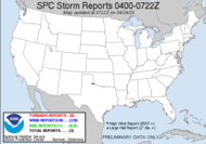
...and it looks like we got a "see text" note for Saturday from the SPC.
SCATTERED TSTMS SHOULD DEVELOP IN VERY MOIST AND PROBABLY WEAKLY CAPPED AIR MASS ALONG AND JUST S OF FRONT...MAINLY FROM LATE MORNING THROUGH AFTERNOON. ALTHOUGH DEEP-LAYER SHEAR IS EXPECTED TO BE WEAK...LOCAL ENHANCEMENTS TO CONVERGENCE AND LOW LEVEL SHEAR ARE POSSIBLE INV OF FRONTAL/OUTFLOW BOUNDARIES. MOST INTENSE TSTMS MAY PRODUCE STG-SVR GUSTS. AMOUNT OF SVR MAY BE RELATED STRONGLY TO COVERAGE OF TSTMS...WHICH IS TOO CONDITIONAL TO PROG ATTM.I did hear on the news this morning that a tornado briefly touched down sporadically in the Brooklyn, NY area. There isn't anything reported at the SPC, but it was reported on CNN Headline News. It must not have been anything significant. I didn't see any footage, and you know that everyone in NY would have been taking video or pictures with their phones... possibly a look-alike? Who knows? All I know is that I am really beginning to get a complex. Am I that much of a weather deterrent??? Everyone experiencing exciting weather, except me... sigh... UPDATE: Public Information Statement from Upton NY NWS and there is the news story. Thanks Steve for those links. So unfair.
 Tropical weather-wise, there is an area in the Central Caribbean that is showing up as an area of interest for the NHC, but they are not expecting it to develop. I have had my eye there on the 23N65W area for a couple of days, so it's sort of disappointing that they aren't expecting anything out of it, though not at all surprising. As I watched, the moisture was being sucked right out of it.
 Have a lovely day,
~Dewdrop


Tropics continue to be quiet. Severe weather is predicted for here today as well. I have my video camera ready to go. I'm starting to enjoy shooting the video of the storms more than the still photography. Seems to translate better to people on the web. I just posted some video I found on the net of the Brooklyn F2. I hope you get some action today.
ReplyDeleteSCM
Maybe, we'll both get our shot at some weather today. Wouldn't that be nice? I am still going to try with the stills, but I suspect that after my first nader, I be after the rotation. I'll check out your video now.
ReplyDeleteI think the tropics will become more active during the next two weeks.
ReplyDeleteIs that a real assessment or wishful thinking? I am thinking of starting a pool... how long will the Dewvoid impact regional weather...? Person to guess closest gets the jackpot.
ReplyDeletereal assesment, with a little wishful thinking sprinkled in for flavoring
ReplyDeleteArea in Caribbean looks interesting.
ReplyDelete...good taste to it, cha cha cha.
ReplyDeletecha cha cha
ReplyDelete