 OK, so 4AM, my weather radio goes off telling me that I am under a tornado watch until noon today. In my groggy, half-asleep state, I made a mental note and continued on with my sleep, thinking... well, I'll just check it out when I wake up. Well, then, I wake up... no internet, no cable, no land line! UGH! A quick check with Rick tells me that it just looks like a drencher passing over... no rotation... no nothing, really. Currently, I am looking at serious Dewv@!d.
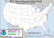
  You see that relatively blank area over south central Georgia...? Yeah, that's me. Welcome to my world. Alabama Mike sent me this...
 COMBINATION OF STRENGTHENING WIND FIELD WITH RICH MOISTURE INFLOW SUGGESTS POTENTIAL FOR LOW LVL STORM ROTATION/ISOLD TORNADOES.
I guess we will see about that... stay tuned.
11AM WELL, I'LL BE!!! They just extended my crazy tornado watch until 6PM and placed me smack dab in the middle of it!!! Don't believe me? See for yourself...
THE NWS STORM PREDICTION CENTER HAS ISSUED A TORNADO WATCH FOR PORTIONS OF
Looks like that secondary line has got the guys somewhat concerned. Reasonably so. If any discrete cells break out ahead, it could be explosive. I am still buried under a solid stratus deck, so I suspect that unless something changes, things will be just a little too stable for my neck of the woods. Check this out...
NORTHERN FLORIDA
SOUTHERN GEORGIA
SOUTHERN SOUTH CAROLINA
COASTAL WATERS
EFFECTIVE THIS WEDNESDAY MORNING AND EVENING FROM 1100 AM UNTIL 600 PM EDT.
TORNADOES...HAIL TO 1 INCH IN DIAMETER... THUNDERSTORM WIND GUSTS TO 70 MPH... AND DANGEROUS LIGHTNING ARE POSSIBLE IN THESE AREAS.DESPITE WEAK THERMODYNAMIC PARAMETERS... FAVORABLE LOW LEVEL VERTICAL SHEAR WILL MAINTAIN A RISK OF TRANSIENT CONVECTIVE INTENSIFICATION AND ASSOCIATED ISOLATED TORNADO POTENTIAL. THREAT IS EXPECTED TO PERSIST THROUGH MUCH OF THE AFTERNOON.
Transient convective intensification...? Who writes this stuff? I need to check my calendar... something's obviously wrong with it. It says it's AUGUST!!!
Tropically, two areas of moderate concern... we shall see. Interestingly, the models place the next wave off of Africa as a named storm hitting the US... eventually. Something to keep an eye on. Anything can happen, right Sam? 2:15PM: My wonderful gtb and I just sat and watched the significant weather statement earned storm fly over my locale (with lightning fast speed) as an amazing gust front. I hope to get pictures and video out tomorrow. Of course, after it passed over us... it went severe... quit laughing.
Toodles,
~Dewdrop
Wednesday, August 13, 2008
Tornado Watch... here?... really?
Labels:
Tornado Watch
Subscribe to:
Post Comments (Atom)


Two horrible words..."Severe After..."
ReplyDeleteLooking forward to some pics Dew!
GFS has me getting hammered on Aug 27th on a few runs now. I'm watching.
SCM
You're not kidding, Mikey.
ReplyDeleteIt was really a spectacular show. The wind was fantastic! I will try to get all that going tomorrow.
So... Hurricane Hanna party at Mikey's around August 27th??? :O)