 SKY WATCH FRIDAY time! Please visit Klaus, Sandy, Ivar, Wren, Louise and Fishing Guy, the team for SKY WATCH FRIDAY (click the word to link and participate!) Thanks to Dot and Tom, who were instrumental in the success of this blogging event. You should definitely come fly with us! In honor of yesterday's outrageous outflow wind event, I thought I would present my favorite outflow wind event.
 This is the shelf cloud in South Dakota, back in June 2007, that carried with it wind ranging from 60-70mph, stirring up a ferocious sand storm. It was spectacular, beyond words, and it really gave me some tremendous hurricane perspective. The specific storm front, was strong enough to blow over a tractor trailer traveling on the interstate. Here are some shots that immediately followed the above.
This shot is what I saw when I turn about 45° to my left. It truly was evil looking!: This was Diane filming Mel capturing video (we were shooting for a television show about storm chasing) of the approaching storm and the amazing shelf cloud, just before the outflow winds (straight-line winds) arrived:
 This shot was the sand just about to overtake us:
 Here, we have been overtaken by a wall of sand, visibility was down to 0!:
 It was one of my most memorable moments out there, especially since I didn't get to the tornado that occurred that day about 25 miles or so from where we were.
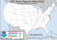
  Yesterday's main weather story was the powerful and deadly wind field that was generated by the squalled out line of storms that resulted after Tuesday's tornadic event. Where my straight line wind event was generated by one very powerful storm segment, the squall line event yesterday produced a wall of damaging wind, hundreds of miles wide, which inspired over 300 wind damage reports. All the blue dots in the linked graphic above represent wind damage reports yesterday. Sadly, one fatality was reported in Davy, WV after the gym roof at Twin Branch Christian Academy collapsed. Another person near Monterey, TN, was injured when he was pinned in a car by a tree. It looks like a disaster area where this wind devastated much of the region, knocking out power to tens of thousands, including some of those just recovering from the ice storm power outage. This report caught my attention:
 30-50 TREES DOWN OFF HIGHWAY 62 LITTLE HURRICANE TRAIL.
30-50 trees... Little Hurricane Trail...? In Tennessee...? Yes, folks, tornadoes can be horribly destructive, but straight-line winds, such as what we saw yesterday, can cause more wide-scale damage and devastation. Where tornadic damage is generally limited to the specific swath of the tornado, a straight-line wind event can wreak havoc across hundreds of miles as we saw yesterday.
Have a great day!
~Dewdrop
Thursday, February 12, 2009
Blows me away!
Labels:
outflow winds,
shelf cloud,
sky watch Friday,
straight line winds,
wind
Subscribe to:
Post Comments (Atom)


Some spectacular shots here. I love the first one. Happy SWF!
ReplyDeleteVery impressive formation on first photo. Enjoy the coming long weekend.
ReplyDeleteScary and thrilling at the same time!!
ReplyDeleteIncredible pictures. The first one has my mouth open! I can't even imagine!
ReplyDeleteAmazing! Like the clouds would suck whatever near it! Happy weekend!
ReplyDeleteSpectacular indeed. Happy swf
ReplyDeleteIn all that wind does your camera suffer sand damage?
ReplyDeleteI'm always amazed how the weather always stops at the US border on US weather maps. LOL I suppose it's a good thing when it's about tornadic events. ;-)
Awesome and scary at the same time! Wow! Terrific shots! Thanks for sharing, have a good weekend!
ReplyDeleteStorms can cause terrible damage. I love that first shot. They are all great but the shelf cloud is amazing.
ReplyDeleteI LOVE photos like this. SOOOOOO cool!
ReplyDeleteThat really is an angry looking sky! Makes a fantastic photo, but I'm not sure I'd be all that keen on getting it.
ReplyDeleteI've never heard of a hurricane making it as far as Tennessee, but we've had them hit the mountains of NC before. Hugo in '89 was still hurricane force when it went through North Wilkesboro in the foothills, tearing out trees by the hundreds and I understand it did some damage as far west as Asheville -- which is definitely in the mountains. It didn't hammer those areas as hard as it did Charelston, SC obviously, but hard enough that nobody's going to forget it. Oddly enough, even though we're much further east, Hugo didn't really bother us in Raleigh. We had to wait for Fran in '96 to get pounded on. A combination of the remnants of Bertha a few weeks earlier, which had saturated the ground already coupled with what was by then Tropical Storm Fran brought down some mighty trees -- 100 feet tall some of them and quite literally too big for me to reach around by even half. For widespread annihilation it's hard to top a hurricane/typhoon. Triple-digit sustained winds over an area 100-miles or more across with a center that doesn't move fast enough to get stopped for speeding in a school zone.
Nasty business.
Awesome shots as always, the first one is unreal. Wow, posts like yours are the reasons why I love skywatch friday.
ReplyDeleteHave a great weekend!
Guy
Regina In Pictures
Wow front seat to these pics, terrific post and pics.
ReplyDeleteWow, those are amazing shots! The cloud shelf is beautiful, even if it is a little scary. We are getting those high winds here in NJ today. One fatality in Morris County. Scattered power outages and tree limbs down all over. Very scary.
ReplyDeleteInteresting info on weather. That first photo is beautiful, but I guess scary, too, if you understand the possible consequences. Amazing how quickly the sand obscured visibility.
ReplyDeleteDramatic and beautiful in same time.
ReplyDeleteGreat shots. That first one is scary looking. Would have hated being caught out in that. Hope you have a wonderful day.
ReplyDeleteReally dramatic and awsome sky wahtc post :)
ReplyDeleteFascinating and scary! I would have been nervous beeing so close to a storm like that! Great shots!
ReplyDeleteThank you for your sweet words on my blog. :)
ReplyDeleteUnfortunately I can't see your pictures at the moment. Only X's. I will visit again tommorow. Hope it is ok by then.
See you around! :)
wow what a story and what great photos....
ReplyDeleteGill in Canada
Awesome photos of the approaching storm! The wind field passed over the Washington, DC area today, leaving some trees down and damage to some houses and power lines. Hagerstown reported gusts as high as 74 mph.
ReplyDeleteFirst I've heard of a shelf cloud. That thing looks quite intimidating!
ReplyDeleteLooks scary. But you these are cool shots. I would have love to take these photos too.
ReplyDeleteWhat a fantastic series of shots. Very impressive. I hope your camera was still working after all sand came over you.
ReplyDeleteGret stuff love the first one shame you missed the twister Don
ReplyDeleteTruly amazing and frightening clouds!
ReplyDeleteHow powerful Mother Nature is!!
a very marvelous shot! frightening though.. but still amazing! :)
ReplyDeleteThose cloud shots are spectacular. The scenes look like something out of a Hollywood disaster movie! Great captures!
ReplyDeleteThat is one scary looking cloud formation, but a perfect shelf cloud example too.
ReplyDeleteVery interesting. We rarely get outrageous wind events here in Adelaide. Your photos tell a great story. I liked South Dakota when we visited. It was hot ad pleasant at that time. My former mother in law grew up in Lead.
ReplyDeleteAwe inspiring, in the traditional meaning of the words.
ReplyDelete