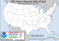
 My, how quickly things change around here. The hatched moderate risk area has greatly expanded since last night's outlook, and apparently, the probability of tornadic activity has gone down. I have been told by Alabama Mike (who has gone south to chase this "beast" as TWC is calling it), "You HAVE to chase now. MOD risk there!!!!" Well, we shall see. I am thinking night. I am thinking explosive. Night and explosive is not my favorite combination.


Who's chasing?
1. Alabama Mike - central Alabama
2. Rick Lipscomb - southwest Georgia
3. Meso Mike - south central Georgia
4. Jim Edds - FL panhandle/Alabama
Who might be chasing?
1. Dew - south central Georgia
2. Jeff Gammons - north Florida I expect that by the time the storm reaches my neck of the woods, it'll be solidly lined out with bowing line segments producing damaging winds and perhaps some large hail (large hail would be a first for me). Unfortunately, I can't just leave today and go after the most tornado prone area today, as I have to manage my time off closely right now and then, there's Mini-Dew, since her dad will be busy chasing stars shooting a zombie movie (seriously)... though the weather might put that on hold. I might just have to settle with the hail and wind leftovers tonight. Wouldn't it be cool if my weather radio went off in the middle of spotter training tonight... sorry guys... gotta split. Gotta put my training to good use. What? It could happen...
This is what Mike is going after. Birmingham hardly ever forecasts tornadoes in their hazardous weather outlook products. SEVERE THUNDERSTORMS ARE EXPECTED TO DEVELOP TODAY... FROM NOON UNTIL 10 PM AHEAD OF AN APPROACHING COLD FRONT. ISOLATED SUPERCELLS WITH LARGE HAIL... DAMAGING WINDS...AND TORNADOES ARE EXPECTED TO DEVELOP ACROSS MUCH CENTRAL ALABAMA... ROUGHLY ALONG AND SOUTH OF INTERSTATE 20...FROM NOON UNTIL 6 PM. AFTER 6 PM...THUNDERSTORMS WITH DAMAGING WINDS AND HAIL ARE LIKELY IMMEDIATELY AHEAD OF THE COLD FRONT AS IT CONTINUES TO PUSH SOUTHEAST.
11AM (my time): A misplaced TVS makes an appearance in Mississippi near Forest. Alabama Mike is headed sw on I-59/20.  Finally a Public Severe Weather Outlook has been issued.
 12:15EST: MD120 for Mike's area...
 THE POTENTIAL FOR SEVERE STORMS CAPABLE OF LARGE HAIL...DAMAGING WINDS AND PERHAPS A FEW TORNADOES IS EXPECTED TO INCREASE THIS AFTERNOON. CONVECTIVE TRENDS ARE BEING MONITORED FOR A POSSIBLE WW. LATEST TRENDS IN VISIBLE SATELLITE IMAGERY INDICATE DEEPENING CUMULUS BANDS.
ONCE STORMS DEVELOP AND BECOME SUSTAINED...THE PRESENCE OF 60-70 KT DEEP LAYER SHEAR AND LONG...STRAIGHT HODOGRAPHS WILL SUPPORT SUPERCELL DEVELOPMENT /SOME SPLITTING/ WITH THE THREAT FOR DAMAGING WINDS...LARGE HAIL AND PERHAPS A FEW TORNADOES.
vivisble... 12:45PM EST: Be safe!
~Dewdrop
Wednesday, February 18, 2009
Moderate risk for severe weather close to home
Labels:
February tornadoes,
Moderate Risk,
Slight Risk
Subscribe to:
Post Comments (Atom)


Looks like an action packed day for Mike. I sure hope everyone in central Bama is prepared.
ReplyDeleteSCM
The latest parameters for Central Bama.
ReplyDelete* Here are the latest severe weather parameters from the 6z (midnight) run of the NAM (North American Mesoscale) computer model, valid at Noon Today:
SBCAPE: 950 J/Kg
0-3KM SRH: 381
LI: -5.3
The CAPE approaches 1000, that means there should be plenty of instability to fuel storms. The SRH is a measure of how much the wind turns, values above 300 support tornadoes. And, the LI, Lifted Index, is an indicator of how prone the air is to rising - negative numbers mean rising air, which supports storms. Anything below -2 is supportive of severe storms.
Good luck if you do chase, Dew! Thanks for the comment; it is definitely a bummer that we did not bag last week, but hopefully I will get another chance at it again soon.
ReplyDelete