 Sorry for the ridiculous delay folks... ran into major internet connection problems then had to retype my post and now that we are in the middle it seems obsolete, but it seems a shame not to share this post... Where most people (myself included) are pointing out the amazingly striking bursts of colors dancing out of the ground in splashes of color painting the budding trees, bringing plants to new life, turning the grass brilliant shades of green, I feel compelled to enjoy the other side of Spring's nature... the weather. I am thoroughly fascinated by the power, the strength and the existence of severe weather. I don't want anything bad to happen. It breaks my heart to hear about fatalities and destruction, but the AWESOME power of the storms truly FASCINATES ME!!!
We have officially entered severe weather season... I mean spring. I mentioned in my previous post that at this point last year, we had seen over 500 tornado reports, but this is typically when you would start to see real severe weather action... in the spring, and here we are, just three days into the season, and we are seeing a doozy of a storm, which some are actually dubbing "A BLOCKBUSTER STORM EVENT". A moist warm front is racing up the plains with a jet stream carrying 120mph winds (seriously) dropping buckets of rain on an already drenched region. With the amount of snow-melt and previous rains, they are looking at the flood impact that this system will present. They worked tirelessly overnight to prepare 2 million sandbags, in an effort to protect life and property.
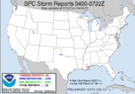
That moist warm front is currently interacting with a low that developed off the Rockies over the northern plains. So technically, an area that yesterday breached high temperature records set back in 1945 with a high yesterday in Rapid City, SD at 77°F, is currently under both a tornado watch AND a blizzard warning because hot on the heels of this ferocious interaction which I will talk more about in a second, is a "POWERFUL SPRING BLIZZARD", which should cause white-out conditions from the heavy snow, as well as power outages. As if that's not enough though, you see on this graphic that there are tornado reports within a hundred miles of blizzard reports. The storm as it crashes in is creating tornado outbreak with warnings popping all over the place. It's not often that you see an area under both a tornado watch and a blizzard warning with tornado warnings at the same time. CRAZY!


 A Public Severe Weather Outlook has already been issued for the hatched area of Moderate Risk for Severe Weather, as defined by the Storm Prediction Center (SPC). You see in the above graphic that the same area is told to have a 15% likelihood of tornadoes, but at this time, there have already been two tornado reports... in Brownlee and Oneill, Nebraska. I've stayed in Oneill. There are actually two reports now on the cell in Oneill which is racing north being at the far northern end of the area of low pressure, which is not where I have seen low's initiate tornadogenesis. It's almost happening backwards from what I would have expected... I would have expected the more southern end of the storm to start firing before this... but what do I know...? I guess things are just slower in the south. The much warmer than normal temps is the cause of this initiation.
THE NWS STORM PREDICTION CENTER IN NORMAN OK IS FORECASTING THE DEVELOPMENT OF TORNADOES...LARGE HAIL AND DAMAGING WINDS OVER PARTS OF THE CENTRAL AND SOUTHERN PLAINS THIS AFTERNOON THROUGH TONIGHT. A SECONDARY AREA OF POTENTIAL WILL BE OVER CNTRL AND NERN NEBRASKA.
Apparently... 2nd came 1st this time.
THE AREAS MOST LIKELY TO EXPERIENCE THIS ACTIVITY INCLUDE
CENTRAL AND EASTERN KANSAS
NORTHERN OKLAHOMAVERY STRONG WIND SHEAR WILL BE FAVORABLE FOR LONG-LIVED...ROTATING STORMS/SUPERCELLS. SHOULD SUPERCELLS FORM...THEY WILL HAVE THE POTENTIAL TO PRODUCE A FEW STRONG TORNADOES...IN ADDITION TO SEVERE HAIL AND WIND.
I will try to keep an eye on things as the night progresses. Hopefully, I can update things tomorrow without problem.
ATHOUGH ISOLATED SEVERE STORMS MAY OCCUR ANYTIME BETWEEN NOW AND SUNRISE TUESDAY IN THE HIGHLIGHTED REGION...THE BULK OF THE SEVERE WEATHER IS EXPECTED LATE THIS AFTERNOON THROUGH LATE THIS EVENING.
Have a great and safe day! Keep those weather radios on!!!
~Dewdrop
Monday, March 23, 2009
What do I love about Spring???
Labels:
blizzard,
severe weather outbreak,
Tornado Watch
Subscribe to:
Post Comments (Atom)


No comments:
Post a Comment
Dew comment, please...