 SKY WATCH FRIDAY time! Our hosts: Klaus Sandy Ivar Wren Louise Fishing Guy
SKY WATCH FRIDAY (click the word to link and participate!) Thanks to Dot and Tom, who were instrumental in the success of this blogging event. You should definitely come fly with us! For today's picture, I decided to share a shot of what our skies have been looking like most days lately. I took this shot back in late August 2008, during an impromptu chase, supported by my dear friend, Christine. I love the boiling cumulus as it swells into the rich blue sky demonstrating the key elements are in line for thunderstorms... moisture, instability and lift. This shot as an example of current skies, further exemplifies our summer-like afternoon thunderstorm pattern, which is getting old, though I love the swelling cumulus... gorgeous.
Now, something I have neglected to talk about this week is Hurricane Preparedness Week. 
 (That is a shot of my wonderful groom--- well, he was just my bf at that time-- and I at the National Hurricane Center-Tropical Prediction Center, when we were there in Miami last June... we saw the end of a tornado that same day!!!) With the Atlantic Basin 2009 Hurricane season just around the corner (it starts on Monday), it is important that people start to get their hurricane minds on and start preparing for the inevitable, a significant chance of hurricanes over the coming months. Today's focus is in the forecast process. One advantage of hurricanes over tornadoes or flash floods, lightning, earthquakes... is the advance notice that people are offered (generally) with hurricanes. Technology has allowed for warnings to be in place well ahead of hurricanes, so that attempts can be made and time is allowed to secure structures... but most importantly to evacuate people and save lives. Homes can be replaced. Material possessions can be replaced, but lives... lives cannot, and can be spared thanks to forecasting and advanced warnings by the National Hurricane Center, Tropical Prediction Center, with regard to hurricanes.
 Part of the mission of the National Weather Service (NWS) Tropical Prediction Center (TPC) is to save lives and protect property by issuing watches, warnings, forecasts, and analyses of hazardous weather conditions in the tropics.
This is accomplished through many ways...
1. OBSERVATION
2. ANALYSIS
3. MODEL GUIDANCE AND INTERPRETATION
4. COORDINATION WITHIN THE NWS
5. PRODUCT GENERATION
6. PRODUCT DISSEMINATION
7. COORDINATION WITH CUSTOMERS
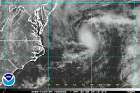
The NHC-TPC do a great job of forecasting, and keeping a watchful eye on the Atlantic Basin for us... As you can see, that low pressure system I wrote about yesterday is still churning off the NC coast and has actually picked up some shower activity. A special tropical outlook has been issued by the National Hurricane Center- Tropical Prediction Center, which indicates:
 THIS SYSTEM STILL HAS SOME POTENTIAL (≤ 30% chance) TO BECOME A TROPICAL CYCLONE OVER THE NEXT 12-24 HOURS BUT IS NOT EXPECTED TO THREATEN ANY LAND AREAS.
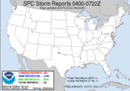
Aside from that, locally just to my west, including much of Alabama and parts of Georgia and north of those areas, there exists a slight risk for severe weather. It's actually relatively late in the season for this neck of the woods, but I am sure, storm chasers, Alabama Mike and Alabama John don't mind. SPC outlook
It looks like the big show in town is coming up next week though... lots of chatter going up about June 5 & 6 in the alley, where models are spouting out information that is leading some to believe there might be a tornado-fest. I guess we'll see. I know those guys are chomping at the bit, having been through a May like this. 1:00PM: Well, what do you know... THE NHC-TPC, at 11AM, issued a public advisory for Tropical Depression 1, which is the first tropical cyclone in the Atlantic Basin for 2009, and arriving on the scene 5 days ahead of the season.
THE DEPRESSION IS NOT EXPECTED TO THREATEN ANY LAND AREAS. THE DEPRESSION IS FORECAST TO BECOME A TROPICAL STORM OVER THE NEXT DAY OR SO...
Looks like we've got the birth of Tropical Storm Ana. Have a great day!
~Dewdrop
Thursday, May 28, 2009
Hurricane preparedness and other summer-like discussion
Subscribe to:
Post Comments (Atom)


Interesting post, Dewdrop. Hurricane season already?
ReplyDeleteAnd next weekend there may be many tornadoes! It amazes me that tornado forecasters can see that far ahead.
That type of cloud is really beautiful and majestic.
ReplyDeleteHope hurricane season goes easy for all of you.
Yikes, lost my #1 spot for the week. Will do better next week :)
I can't believe it's hurricane season already as well.
ReplyDeleteIf you have a minute can you pop over to my blog and tell me what sort of clouds I took photos of please?
Thanks, Gill in Canada
I love your beautiful sky shots. The clouds are so appealing to me. Also liked seeing the stormchaser herself and your husband too. Great post.
ReplyDeleteInteresting! I am so glad I don't live in a place with hurricanes! It is scary to watch that on TV!
ReplyDeleteWhat a lovely big cloud! You've made me very happy to NOT worry about hurricanes, where I live... LOL Lots of clouds to enjoy however!
ReplyDeleteHurricanes that sounds windy XXX Don
ReplyDeleteGreat shot and interesting post as always :) Happy sky watch.
ReplyDeleteReally interesting post again!Hurricans are so terrible.Very beautiful photo of blue sky!Thank you for sharing!Have a nice weekend!
ReplyDeletea terrific thursday hello.
ReplyDeleteyour clouds look a little like what we have been viewing in between the overcast skies.
beautiful capture.
have a lovely evening.
Love your great clouds and the photo-update of the happy couple.
ReplyDeleteDew: Wonderful photo of the building clouds. That was a neat photo of you and the hubby.
ReplyDeleteGreat collection of photos for Sky Watch Friday. And to think silly me always called them pretty clouds bubbling off the horizon.
ReplyDeleteThanks for sharing with us all in Sky Watch Friday.
Hi Dew,
ReplyDeleteLove that roiling cloud - it reminds me of surf. Luckily, I don't have to worry about Hurricanes here in CO - other bad weather, though!
A totally gorgeous world.
ReplyDeleteWow Dewdrop,
ReplyDeleteWonderful sky watch shot. Your weather knowledge is amazing. Informative and breathtaking shots all in one post. Nicely done : )
Hi Dew
ReplyDeleteGreat post and info.. and a great Sky Watch picture to boot... :O)
The happy couple are look great too... hope you both have an excellent weekend
Tom
I love the picture of the clouds--looks to me like there's a great big puffy teddy bear sitting there!
ReplyDeleteBeautiful--fills my eyes, which is the biggest compliment I can give!
Those clouds in your photo are amazing. They make the buildings look so small. Wonderful!
ReplyDeleteCongrats on your marriage, I wish you all happiness~
one thing is certain: the clouds look magnificent, but the hurricanes don't. I wish you wonderful skies, but no trouble!
ReplyDeleteTruly beautiful clouds so white and crisp I'd like to taste them.
ReplyDeleteI can't even imagine how it would be to live in an area where there is a risk for hurricanes. I think the few storms we get here is worrying enough.
Really interesting post with some great information. Thanlk you for posting it!!
ReplyDeleteWe have had lots of clouds like that, in our skies over the last week ...unfortunately they have pretty much come to nought. We really need the rain here in Northern Nevada.
My fingers are crossed, though .. that we don't get dry lightening, which often happens with thunderdtorms at this time of the year. That scenario is a disaster, as far as lightening caused wildfires go ...
Great shot of the cumulus clouds. They do look as though they're boiling.
ReplyDeleteAmazing clouds!! Great hurricaine info. I hope people pay attention to it!
ReplyDeleteIt really puts the British weather in perspective when I see and read your posts. Now how to I get "my what a swelling cumulus" into a conversataion here.
ReplyDelete