 SKY WATCH FRIDAY time! Our hosts: Klaus | Sandy | Ivar | Wren | Louise | Fishing Guy
SKY WATCH FRIDAY (click the word to link and participate!)
Thanks to Dot and Tom, who were instrumental in the success of this blogging event. You should definitely come fly with us! It's not a secret that I love crepuscular rays... I have written whole blog posts about them, but the ones I saw this past Thursday were striking to me. Usually, it's the lit part that captures my attention, but this time, it was the clouds's shadow between the crepuscular rays that caught my attention, seeming to add some drama and depth to the sky and the setting sun.
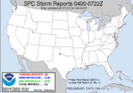
Well, though we started out with a below average tornado year, it looks like things quickly picked up and launched us over average.  Yesterday, tornado roared around northern Alabama, while Mike was in Huntsville. A 10.9 mile long EF2 tornado left a wake of destruction. Here is the report:
PUBLIC INFORMATION STATEMENT
NATIONAL WEATHER SERVICE HUNTSVILLE AL
518 PM CDT WED MAY 6 2009
...PRELIMINARY STORM SURVEY INFORMATION FROM LIMESTONE AND MADISON COUNTIES...
* EVENT TYPE: TORNADO
* EVENT DATE: 05/06/2009
* ESTIMATED PEAK WIND: 115.0 MPH
* PRELIMINARY RATING: EF-2
* PATH LENGTH: 10.9 MILES
* MAXIMUM PATH WIDTH: 75 YARDS
* SUMMARY: THE TORNADO TOUCHED ALONG SEGERS ROAD IN EASTERN LIMESTONE COUNTY SNAPPING AND UPROOTING NUMEROUS LARGE TREES. A TREE FELL ON A MOBILE HOME ON HARDIMAN ROAD AND SPLIT IT IN HALF. THE TORNADO CONTINUED TO MOVE NORTHEAST AND CROSSED INTO MADISON COUNTY. SIGNIFICANT TREE DAMAGE OCCURRED IN SEVERAL SUBDIVISIONS ALONG COUNTY LINE ROAD... WINDOWS WERE BLOWN OUT OF SEVERAL HOUSES IN THE HUNTINGTON CHASE SUBDIVISION ALONG WITH SIGNIFICANT ROOF DAMAGE. A LARGE ATTACHED GARAGE WAS COMPLETELY FLATTENED ALONG BROWNS FERRY...AND ROOF DAMAGE WAS OBSERVED IN THE BRIDGEFILED SUBDIVISION. SEVERAL RESIDENTS OF BRIDGEFIELD NOTED THAT THEY RECEIVED THE TORNADO WARNING AND TOOK COVER BEFORE THE STORM HIT.
THESE FINDINGS ARE PRELIMINARY AND ARE SUBJECT TO ADJUSTMENT. It seems that the southeast over the past week has been the staging area for disaster, with the tornadic action, torrential (flooding) rainfall, mosquito outbreaks... No worries, it looks like severe weather is returning to the plains tomorrow with a moderate risk for severe weather outlined in Oklahoma. Of course, it would be hard for this year to top last year's wild tornadic action, with a whopping 1690 tornadoes confirmed last year.
  Outrageous. Seems sad to me that out of 1690 tornadoes, I saw NONE OF THEM! I've got to change that!
Have a great day!
~Dewdrop
Thursday, May 07, 2009
Tornado trends 2009
Labels:
sky watch Friday,
tornado trend for 2009
Subscribe to:
Post Comments (Atom)


Join the "Tornado-less" club, Jenn! We'll get our 'nader fest eventually. Someday. ;)
ReplyDeleteLove your Skywatch Friday photo, as always. I may be doing the Skywatch Friday thing again starting next week, now that I have some new photos.
No tornado's, that makes two of us.
ReplyDeleteSCM
I didn't know the names ascribed to the phenomenon you've described here. Thank you!
ReplyDeleteI've loved clouds and the way the sun catches the light as they pass, since I was a child. When I was in first and second grades I learned the names of all the different kinds of clouds.
I've been watching them since I could appreciate the skies. Nice to discover someone with that same kind of love.
Thank you for sharing!
PS GORGEOUS picture--I love it when the clouds make shadows in upon themselves. It is a truly unusual sight.
ReplyDeleteWonderful photo, my friend.
ReplyDeleteI too always learn something new here. I love these crepuscular rays, which we get quite a few of here.
ReplyDeleteHave a great weekend.
80+ confirmed tornadoes so far this year in Alabama (and surveys add to that number still today). I have not seen one. I have seen a few storms that were producing tornadoes, I have seen a few storms that produced one before it got to my location and after they passed my location, but I have no photos to show for it. Of course, I was IMHO actually IN an EF0 but it wasn't confirmed. Grrrrrrr!
ReplyDeleteA lovely sky, Dewsrop. I never knew the name for the rays, and will likely forget as soon as I submit my comment! :-D
ReplyDeleteI beg you, please don't say 'Tornado' around my mother... she's obsessed and is absolutely sure every one of them is headed for wherever she is hiding from them.
Beautiful photo of light across the sky, thanks for sharing with us all in Sky Watch Friday.
ReplyDeleteWELL DONE just been watching rays on our journey home from our Grandsons birthday party
ReplyDeleteGreat photo and good skywatch Friday post.
ReplyDeleteGorgeous sky - almost looks like it's through a prism!
ReplyDeleteGreat picture of sky and a really interesting SWF post again like every week!
ReplyDeleteBeauty post as always!!!
ReplyDeleteHave a great weekend.
Guy
Regina In Pictures
beautiful capture and as always i enjoyed your informative post...
ReplyDeletehave a fab friday.
erin
Love the detailed information in your posts! This is truly a beautiful sky and the light playing around the cloud shapes is stunning!
ReplyDeleteI would think it's a good thing not having seen a tornado. Then you have stayed out of harms way. Still I can well understand a fascination with them and seeing one at a distans must be quite a kick.
ReplyDeleteYour photo is so interesting. I too love those rays but the shadow particularly on the right hand side is so sharp. I've never really noticed how the clouds cast shadows. Excellent capture.
I can also understand the fascination towards the tornado. I have seen breathtaking photos of them, seen them on TV - and felt really thankful they don't appear in my country!
ReplyDeleteBeautiful photo you have!
An absolutely stunning photo!
ReplyDeleteNow I need to instigate a conversation when I can say crepuscular rays in context. Not only a glorious heavenly image but I always walk away a little sky wiser.
ReplyDeleteA really stunningly beautiful photo and you always have some good/interesting info to pass on! Much appreciated! Have a great weekend!
ReplyDeleteGreat shot of a beautiful sunset...enjoy all the info you give...
ReplyDeleteI love the sky shot and as always interesting post. We have had some tornadoes my way (NC) although none at my house which suits me.
ReplyDeleteScience adds to the beauty
ReplyDeleteThe combination of the sun. mon and clouds present in a multitude of ways and yours is just awe inspiring.
ReplyDeleteYou have a breath taking shot here Dew.
ReplyDeleteLovely. Glad there are no tornado's.
I will add a new key word to my vocabulary! Thanks for all your skywatching and storm spotting.
ReplyDeleteInteresting maps and I like your photo.
ReplyDeleteLove the way the light is streaming through the cloud. Nice shot.
ReplyDeletePhoto and information are both fascinating. Love the rays you captured in the shot. :)
ReplyDeletethis is a wonderful photograph! it is truly captivating!
ReplyDeleteI recently posted a great shot of a tornado running through a house fire. Sheer power.
ReplyDeleteThanks for all the visits and kind words and encouragement. I appreciate it!
ReplyDeleteKen, Mike and Mikey, is there an official club, having single-handedly killed a high risk, PDS situation, I should qualify as president. I hope you will come back to sky watch.
Beth, glad you learned something. I definitely have an intense passion for the sky!
Mike, amazing stats on Bama naders... crazy. I agree with you on that one... 3 directional winds, NWS screaming for me to get you the heck out of there... hm.
Barb, crepuscular.
Tarolino, yeah, I'm probably pretty non-traditional where that is concerned.
Babooshka, My, my, aren't you casting a crepuscular ray-like glow...?
Carver, I don't want one at my house, either.
Colin, I couldn't find it... do you have a direct link?