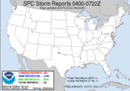
 Much of the southeast is included in a slight risk for severe weather today, but the SPC has just issued a discussion indicating that the blue outlined area in Oklahoma, Kansas, Arkansas, Missouri will be upgraded to a moderate risk. Looks to me like that are already getting some significant wind with a punchy looking bow echo that is currently raging across Oklahoma, where wind and hail reports are already pouring in.
 The instability forecast is through the roof with MLCAPE over 4000J/KG!!!! That is some seriously unstable air.
 MAINTAIN AN ORGANIZED RISK OF SEVERE STORMS THROUGH THE AFTERNOON AND EVENING AS ACTIVITY SPREADS INTO PARTS OF WESTERN TN/NORTHERN AL/NORTHERN MS. FORECAST SOUNDINGS SUGGEST PARAMETERS FAVORABLE FOR VERY LARGE HAIL...SIGNIFICANT DAMAGING WINDS...AND ISOLATED TORNADOES ACROSS THIS AREA. AN UPGRADE TO MODERATE RISK MAY OCCUR LATER TODAY AS THE CORRIDOR OF GREATEST THREAT BECOMES MORE CLEAR AND IF STORMS INTENSIFY AS CURRENTLY EXPECTED.
... which has happened...
Not much talk of tornadoes though... so Vortex2 might not get a great finale as they might have hoped. REGION WILL BE UPGRADED TO A MODERATE RISK FOR THE 1630Z CONVECTIVE OUTLOOK.
REGIONAL SOUNDINGS INDICATED THE PRESENCE OF ANY ALREADY STRONGLY UNSTABLE AIR MASS WITH MUCAPE OF 3000-4000 J/KG. 12/00Z HIGH RESOLUTION MODEL RUNS HAVE VERIFIED REMARKABLY WELL WITH THE EVOLUTION OF NERN OK BOW ECHO WITH THESE DATA TAKING SYSTEM THROUGH AR INTO NRN MS TODAY. GIVEN THE DEGREE OF INSTABILITY AND 40-50 KT OF DEEP-LAYER SHEAR...SETUP WILL BE FAVORABLE FOR A CORRIDOR OF SIGNIFICANT WIND AND HAIL DAMAGE. ADDITIONAL STORMS DEVELOPING DOWNSTREAM FROM BOW ECHO WILL ALSO POSE A RISK OF LARGE HAIL AND DAMAGING WINDS.
Have a great weekend!
~Dewdrop
Friday, June 12, 2009
Significant part of southeast under a risk for severe weather
Labels:
Slight Risk
Subscribe to:
Post Comments (Atom)


Things have been insane down here for the past few days, that's for sure. I'm already looking at possibly chasing again this evening. I have never been able to chase this much, this close to home since I started seriously chasing.
ReplyDeleteGFS is painting some ridiculous CAPE values in the North Central Texas area around the 0z timeframe. We are talking CAPE in excess of 5000 J/Kg! Nuts! Now, do I believe it is that unstable? Not hardly, but the FWS sounding for 12z was encouraging, with forecast CAPE of around 4000 J/Kg.
Wish me luck!
By the way, I finally saw a tornado two nights ago! Unfortunately, I was driving and unable to shoot it, but it still counts.
Good grief!!! I love storms, but I'm not sure I'd like to meet up with that one. Wow.
ReplyDelete