 SKY WATCH FRIDAY time! I am SUPER busy with stimulus yuck, so I might not get a chance to say hi. Please don't take offense. Thanks for the visit in advance. Our hosts: Klaus Sandy Ivar Wren Louise Fishing Guy
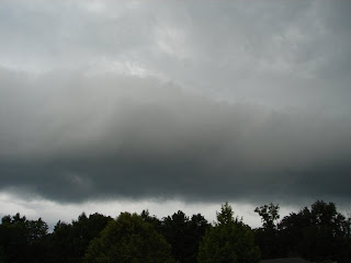
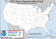
Thanks, also,to Dot and Tom, who were instrumental in the success of this blogging event. You should definitely come fly with us!  Last night, I had the rare privilege of shooting a roll cloud, as it approached my home just ahead of a severe warned cell that ended up remaining well north of me at its greatest intensity (are we surprised?) To the right, I have posted a radar capture of my best approximation of what it looked like at that precise moment.
A Roll cloud (like a shelf cloud) is an example of an arcus cloud. An arcus cloud is a low, horizontal cloud formation associated with the leading edge of thunderstorm outflow, or occasionally with a cold front even in the absence of thunderstorms. Cool, sinking air from a storm cloud's downdraft spreads out across the surface with the leading edge called a gust front. This outflow undercuts warm air being drawn into the storm's updraft. As the cool air lifts the warm moist air, water condenses creating a cloud which often rolls with the different winds above and below (wind shear).
I shot some video.
A roll cloud is a low, horizontal, tube-shaped, and relatively rare type of arcus cloud. They differ from shelf clouds by being completely detached from the thunderstorm base or other cloud features. Roll clouds usually appear to be "rolling" about a horizontal axis. They can be a sign of possible microburst activity.
~ source
In other news... I haven't really focused on the Eastern Pacific Hurricane season because "generally" those storms don't pose a threat to land. Well, lo and behold, major Hurricane Felicia, currently a category 4 hurricane has her sites set on Hawaii... like a dead-on collision. Of course, a story like that becomes major news... "Major Hurricane Expected to Slam into Hawaii"... what they aren't emphasizing is that this major hurricane is forecast to weaken tremendously, if not dissipate by the time she gets to Hawaii. 
AFTER DAY 3, THE HURRICANE SHOULD BE OVER SEA SURFACE TEMPERATURES LESS THAN 26C AND HEADING TOWARD INCREASING WESTERLY SHEAR. STEADY WEAKENING IS INDICATED IN THE FORECAST AT THAT TIME. ALL THE GLOBAL MODELS SHOW A MUCH WEAKER VORTEX AS THE CYCLONE APPROACHES THE HAWAIIAN ISLANDS...AND THE SHIPS MODEL EVEN DISSIPATES THE SYSTEM BY THAT TIME.
Be certain to read my post about "late blooming hurricanes" before letting your guard down for the Atlantic season.Acts 27:25
So keep up your courage, men, for I have faith in God that it will happen just as he told me.
God bless,
~Dewdrop
Thursday, August 06, 2009
Rolling with the roll cloud
Labels:
roll cloud,
sky watch Friday
Subscribe to:
Post Comments (Atom)











a good thursday.
ReplyDeletewe see roll clouds here often. thanks for the info concerning. i never saw them in california.
as always enjoy the info and wishing you a wonderful weekend.
a lovely series of photos, I have never heard of a roll cloud before?
ReplyDeleteGill in Canada
I Like the roll cloud photos and writeup'
ReplyDeleteTo see Skies over the Marsh, Click here.
Come visit anytime,
Troy and Martha
Terrific post Dew!
ReplyDeleteLoved the video and was so glad you named the music - super.
Don't work too hard. :)
My post is here: Carletta’s Captures.
Those clouds look like they really have some heft to them!
ReplyDeleteGreat photo´s and a interestings post again!Thank you for sharing!Have a nice weekend!
ReplyDeleteThe clouds do look like they are rolling. Great shots.
ReplyDeleteAWESOME post and pictures AGAIN!
ReplyDeleteLOVE your blog.
Take care and Happy SWF
Great collection of photos for sky watch friday and video clip as well. Thanks for sharing with us all.
ReplyDeleteWonderful capture of the roll cloud Dew and the video too.
ReplyDeleteThank you for all the information you give on your site. I find it very helpful.
Have a good weekend.
Beautiful!
ReplyDeleteGr.
P-TER
Thanks for the information about roll clouds. I wonder if I would recognize one if I saw it. I'll try to remember your description. ;-)
ReplyDeleteNice captures, i often see skies like this but here in holland it's kinda normal, but never with really heavy storms or beginning tornado's....
ReplyDeleteLove your captures and your short film,
Have a nice SWF
What an interesting sky formation. You really present the phenomen very well.
ReplyDeleteWe had one of these here once. Never seen anything like it since. Of course I had no idea what it was. Always rely on you to name those clouds. weird and wonderful.
ReplyDeleteWe had one of these here once. Never seen anything like it since. Of course I had no idea what it was. Always rely on you to name those clouds. weird and wonderful.
ReplyDeleteI love watching thunderstorms, but living on the Florida Gulf Coast, hurricanes not so much.
ReplyDeleteHi. Thanks for the info. Its been raining out here and we have storms here and there. Our skies been like that.
ReplyDeleteGreat captures.
Spectacular cloud captures, they look so threatening though!
ReplyDeleteYour roll cloud almost looks like a wave crashing towards you. Nice captures and liked the video.
ReplyDeleteGreys are good too.
ReplyDeleteSydney - City and Suburbs
I love to see a storm literally rolling in!
ReplyDeleteThank you for an informative post on the roll clouds.
ReplyDelete- celine
http://indicainq8.wordpress.com/
Fascinating detail as always! I see these clouds formations quite a great deal lately! (I didn't know their name, however!)Sometimes they herald storm as you say, but they do look as though the sky is creeping closer to the earth!
ReplyDeleteAwesome shots. The information on roll cloud very new to me. Great.
ReplyDeleteGreat series!
ReplyDeleteIt's always very impressive when a rollcloud comes over.