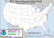
 Well, there is major snow storm in the midwest... severe weather in the south as a low pressure system makes its way across the country. The snowfall in some areas is reaching record daily snowfall totals.
 Advisory about Dangerous Winter Storm
The Upper Mississippi River Valley Region will be impacted by a dangerous winter storm today through Wednesday. Significant snow, blowing and drifting of the snow, and the potential for white-out conditions all appear likely for this period. Winter storm or blizzard warnings are in effect for much of the region this afternoon through Wednesday evening.Now, on the southern end of this crazy winter storm, there is potential for severe weather. A threat for tornadoes exists in the south for today.
The storm will strengthen over Oklahoma today, moving northeast to the southern tip of Lake Michigan by Wednesday morning. Snow has already spread into northeast Iowa, southwest and central Wisconsin this morning, and will continue to spread northward through the day today. Snow will continue to fall across the region through most of Wednesday, gradually diminishing Wednesday evening as the storm system moves off to the northeast. Accumulations across the region will be in excess of 6 inches. Amounts of 12 inches or greater are possible across portions of eastern Iowa into southern Wisconsin.
In addition to the snow, the winds will become strong and gusty later tonight, increasing into the 20 to 30 mph range...with gusts as high as 40 mph. This will lead to blowing and drifting of the falling and fallen snow. Poor visibilities will result, with white-out conditions possible. In the open and unsheltered areas of southeast Minnesota and northeast Iowa, where the winds will be strongest, blizzard or near blizzard conditions could develop overnight tonight through the day on Wednesday.
This early season winter storm will cause significant impacts on travel, especially during the morning commute on Wednesday. Be prepared for school closings and event cancellations on Wednesday. Roads will become very treacherous, possibly impassable at times. Stay abreast of the latest information on this developing winter storm via the links below.
Winter Monitor
Winter Storm/Blizzard Warning
Hazardous Weather Outlook
Expected local snowfall totals for the event
Graphic Weather Story
Winter Storm Safety and Preparedness Information
EXPECT INCREASE IN TSTMS...SOME ROTATING... THROUGH THE AFTERNOON ALONG THE LOWER MS RIVER VALLEY WITH DIURNAL HEATING.
 Regardless of your location, looks like you have some sort of extreme weather happening or about to happen. Exercise extreme caution if you head out into any of it.
Have a great safe day!
~Dewdrop


When I saw the news last night about the storms sweeping across our nation, I worried about you. I'm so glad to hear you are alright and outside the unstable "box." In the meantime, though--because the weather can be capricious,I shall be praying for saftey for you and your family.
ReplyDeleteGod bless you! I hope you capture some amazing cloud pics!